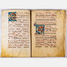
2 Illuminated Books of Hours LeavesSchmidt's Antiques Inc. Since 19114.8(431)See Sold PriceMar 02, 2024
Illuminated Manuscript Leaf of The CrucifixionSchmidt's Antiques Inc. Since 19114.8(431)See Sold PriceMar 02, 2024
RARE 1930s AUTOGRAPH BOOK FEATURING RUTH & GEHRIGJohn McInnis Auctioneers,LLC4.6(502)See Sold PriceFeb 25, 2024
Timetable, Paper and Ephemera Lot-Eastern USA RailroadsJM Hobby Supply and Railroad Artifact Auctions4.4(126)See Sold PriceFeb 24, 2024
SCARCE 1971 Kim Il Sung Signed Book "ON THE WORK OF THE WOMAN'S UNION"Rbfinearts4.4(571)See Sold PriceFeb 24, 2024
1885 CIVIL WAR 1ed Famous Memoirs US Grant Sheridan Sherman 6v RARE LOT MapsSchilb Antiquarian Rare Books4.8(421)See Sold PriceMar 10, 2024
"WINTER AND SUMMER IN MAINE" 1904 PHOTO ALBUMJohn McInnis Auctioneers,LLC4.6(502)See Sold PriceFeb 25, 2024
1821 THE (3) VOYAGES of CAPT JAMES COOK VOL. I-VIIJohn McInnis Auctioneers,LLC4.6(502)See Sold PriceFeb 24, 2024
[BASEBALL]. [SHEET MUSIC]. KALBFLEISCH, J. H. The Live Oak ...Potter & Potter Auctions4.6(539)See Sold PriceMar 07, 2024
Illuminated Manuscript Leaf of The VisitationSchmidt's Antiques Inc. Since 19114.8(431)See Sold PriceMar 02, 2024
Illuminated Manuscript Leaf of GethsemaneSchmidt's Antiques Inc. Since 19114.8(431)See Sold PriceMar 02, 2024
c1700s RARE Arabic Handwritten Manuscript Middle East Persia Journal ARABIASchilb Antiquarian Rare Books4.8(421)See Sold PriceMar 10, 2024
Sold[ATLASES] GRAY, O.W.* [ATLASES] GRAY, O.W. Gray's Atlas of the United States, with General Maps of the World. Accompanied by Descriptions Geographical, Historical, Scientific and Statistical. Philadelphia: Stedman, BrownSee Sold Price
SoldHundreds of maps from O.W. Gray atlasesHeading: (Atlas Maps) Author: Gray, O.W. Title: Approx. 100 or more maps from Gray's Atlas Place Published: Philiadelphia Publisher: Date Published: c.1876 Description: ApprSee Sold Price
FRAMED O.W. GRAY'S ATLAS MAP OF OCEANICA, 1873Framed Gray's Atlas map of Oceanica (Oceania), Ormando Willis Gray, Philadelphia, c.1873, covers Polynesia, Australasia, and Malaysia, sight: approx 12.5"h, 15.5"w, overall: approx 21.25"h, 24.25"w, 6See Sold Price
Americas.- Gray (O.W.) Gray's Atlas of the UnitedAmericas.- Gray (O.W.) Gray's Atlas of the United States, with General Maps of the World..., 72 hand-coloured lithographed maps and city plans, 23 double-page and one folding, business directory for BSee Sold Price
SoldAmerica.- Gray (O.W.) Gray's Atlas of the UnitedAmerica.- Gray (O.W.) Gray's Atlas of the United States, with General Maps of the World, title, with 73 hand-coloured lithographed maps and city plans, 23 double-page and one folding, business directoSee Sold Price
Sold1881 - The National Atlas by O.W. Gray.The National Atlas, Containing Elaborate Topographical Maps of the United States and the Dominion of Canada, with Plans of Cities and General Maps of the World. Also, descriptions and tables, historicSee Sold Price
Sold2 vols. American Atlases: Walling, Henry F.; Gray2 vols. American Atlases: Walling, Henry F.; Gray, O.W. New Topographical Atlas of the State of Pennsylvania. Philadelphia: Stedman, Brown & Lyon, 1872. Folio, orig. bds., gilt-lettered morocco coverSee Sold Price
SoldO.W. GRAY THE NATIONAL ATLAS 1880Special Edition for New Jersey. Hand-colored maps. Appears complete. Dimensions: H 17.75" x W 14.5" x D 1.5" Condition: Clean and bright throughout with slight age toning. In worn cloth binding.See Sold Price
SoldAtlas of 40 color maps (O. W. Gray, 1876-1882).[Atlases]. 2 Titles. Folio. ++ Atlas published by O.W. Gray & Son containing 40 maps (39 in full color) of US states, major cities, and foreign countries, c.1876-1882. Lacking spine, edges worn. 3 mapSee Sold Price
Sold(MASSACHUSETTS.) Walling, H.F.; and Gray, O.W. Official(MASSACHUSETTS.) Walling, H.F.; and Gray, O.W. Official Topographical Atlas of Massachusetts, from Astronomical, Trigonometrical, and Various Local Surveys. Engraved pictorial title and 16 hand-coloreSee Sold Price
SoldMaryland atlas 1873. 32 maps w/ orig hand colorin[Atlas/Maryland & DC]. S.J. Martenet, H.F. Walling, and O.W. Gray. New Topographical Atlas Of The State Of Maryland And The District Of Columbia, With Descriptions Historical, Scientific, And StatistiSee Sold Price
Sold1 vol. Walling, Henry F.; Gray, O.W. New Topograp1 vol. Walling, Henry F.; Gray, O.W. New Topographical Atlas of the State of Pennsylvania. Philadelphia: Stedman, Brown & Lyon, 1872. Folio, orig. gilt-lettered black cloth, sheep back & corners; rubbSee Sold Price
SoldWalling, Henry F.; Gray, O.W. New Topog1 vol. Walling, Henry F.; Gray, O.W. New Topographical Atlas of the State of Pennsylvania. Philadelphia, 1872. Folio, orig. 1/4 sheep & gilt-lettered cloth; extremities rubbed. Complete with all colorSee Sold Price
SoldATLAS MASSACHUSETTS H.F. WALLING & O.W. GRAY 1871ATLAS MASSACHUSETTS H.F. WALLING & O.W. GRAY 1871See Sold Price
PennsylvaniaTitle: Pennsylvania Date: 1875 Cartographer: GRAY, FRANK H. ? Publisher: O.W. GRAY & SON Description: Extremely detailed atlas map, pp.56-57 believed from a Gray's atlas. Lightly browned. Height: 15.7See Sold Price
Gray's Atlas Map of United States & Geologic FormationsGray's Atlas Map of United States & Geologic Formations. Gray. O.W., Hitchcock, Chas. H., 1873, Double Folio – 16.00 H x 26.20 W Inches, Colored by geologic formation. Esp. vivid in far west with muSee Sold Price
Map of Georgia & Savannah by Gray, 1873Original lithograph of Georgia from Gray's Atlas Map of Georgia. Philadelphia: O.W. Gray, 1873. Details Savannah, Savannah River entrance, St. Simons Sound, Brunswick Harbor and Turtle River. Finely dSee Sold Price
SoldEarly atlas map of Louisville, Ky. By O.W. GrayClean and fine map of Louisville, Kentucky from the first edition of Gray’s National Atlas. Maps of Louisville in early atlases were usually joined with another city on the page. This 1875 example dSee Sold Price
SoldCity of Louisville KentuckyTitle: City of Louisville Kentucky Publication Date: 1876 Cartographer: GRAY, O.W. Publisher: O.W. GRAY & SON Dimensions: 11.6 X 14 Additional Information: Detailed map showing streets, districts, cemSee Sold Price
SoldColoradoTitle: Colorado Publication Date: 1886 Cartographer: GRAY, FRANK A. Publisher: GRAY, O.W. & SON Size: 11.75Height - 14.75Width Colton map from Gray's The National atlas... Special edition. Reverse: IdSee Sold Price
West Indies and Central AmericaTitle: West Indies and Central America Cartographer: GRAY, FRANK A. Publication Date: 1886 Publisher:GRAY, O.W. & SON Size:16 X 12TRUE Reserve: $45.00 Shipping: Domestic: Flat-rate of $18.00 to anywheSee Sold Price
Gray's New Map of WisconsinTitle/Content of Map: Gray's New Map of Wisconsin Cartographer: GRAY, FRANK A.| WILLIAM H. HOLMES Date: 1886 Publisher: GRAY, O.W. & SON Size: 24.6Height - 17Width Colton map from Gray's The NationalSee Sold Price
North AmericaTitle: North America Publication Date: 1886 Cartographer: GRAY, O.W. Dimensions: 14.75Height - 13Width Publisher: GRAY, O.W. An 1855 J.H. Colton map from Gray's The National atlas... Special edition.See Sold Price
Gray's New Map of North Carolina and South CarolinaTitle: Gray's New Map of North Carolina and South Carolina Publication Date: 1886 Cartographer: GRAY, FRANK A. Publisher: GRAY, O.W. & SONSize: 16Height - 27Width From Gray's The National atlas... SpeSee Sold Price
Attributed to Mitchell Vance & Co. Four Arm GasolierGray's Auctioneers4.5(186)See Sold PriceMar 06, 2024
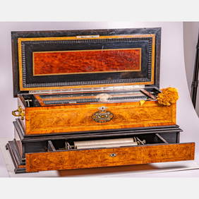
Walnut Polyphon, Style 104, Coin Operated Music BoxGray's Auctioneers4.5(186)See Sold PriceMar 06, 2024
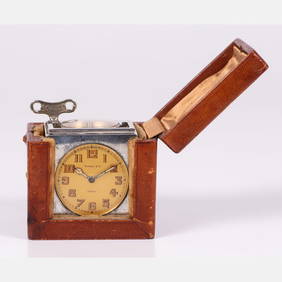
Rare Tiffany & Co. Paris Silver 5 Function Travel Clock in Leather CaseGray's Auctioneers4.5(186)See Sold PriceMar 06, 2024
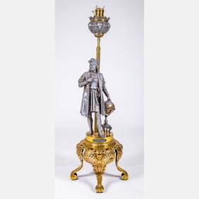
Victorian Christopher Columbus Kerosene Floor LampGray's Auctioneers4.5(186)See Sold PriceMar 06, 2024
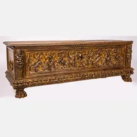
Queen Anne Cross-Banded Walnut Highboy, Massachusetts, 1740-1760Gray's Auctioneers4.5(186)See Sold PriceMar 06, 2024
![[ATLASES] GRAY, O.W. First Image](https://p1.liveauctioneers.com/197/119933/61100808_1_x.jpg?height=282&quality=95&version=1522758048&width=282)

![[ATLASES] GRAY, O.W. First Image](https://p1.liveauctioneers.com/197/119933/61100808_1_x.jpg?height=282&quality=1&version=1522758048&width=282)


![[BASEBALL]. [SHEET MUSIC]. KALBFLEISCH, J. H. The Live Oak ... (1 of 5)](https://p1.liveauctioneers.com/928/318880/171361400_1_x.jpg?height=282&quality=70&version=1707501302)


![[ATLASES] GRAY, O.W. (1 of 1)](https://p1.liveauctioneers.com/197/119933/61100808_1_x.jpg?height=282&quality=70&version=1522758048)