SoldAtlas : The Times Atlas published at the Office ofAtlas : The Times Atlas published at the Office of The Times 1895, folio size bound in quarter leather.See Sold Price
SoldBook: '' The Times Atlas '' published at The Office ofBook: '' The Times Atlas '' published at The Office of ''The Times'', London , 1895, containing numerous , having leather bound spine with gilt lettering to cover.See Sold Price
Sold'The Times Atlas' published London 1900, 'containing'The Times Atlas' published London 1900, 'containing 132 pages of maps and comprising 196 maps'See Sold Price
1895 Map of JapanAuthor: Bartholomew Title: 1895 Map of Japan Materials: Ink on Paper Dimensions: 18"X23" Description: Map of Japan engraved for John Bartholomew and company. Part of the Times Atlas published by the ESee Sold Price
Sold2 Times Atlas'The Times Atlas' published 1896; 'The Times Atlas and 'Gazetteer of The World', published 1922See Sold Price
'The Times Atlas of the World', published by 'The'The Times Atlas of the World', published by 'The Times', London 1920, gilt tooled red cloth boards, also two gazetteers (3)See Sold Price
SoldTimes Atlas 1895 Map. North Polar RegionsLithograph Map Published 1895, London for "The Times Atlas" Centre fold as published. Paper Size: 21.5 x 16 inch (54 x 41cm) Good ConditionSee Sold Price
SoldTimes Atlas 1895 Mixed Lot of 10 Large MapsIncl Balkans, France, Switzerland, Spain/Portugal, European Russia, Austrian Alps, and Austria-Hungary. Lithograph Map Published 1895, London for "The Times Atlas" Centre fold as published. Paper SizeSee Sold Price
SoldTimes Atlas 1895 Lot of 4 Continents MapsIncl Europe, Asia, North America and South America. Lithograph Map Published 1895, London for "The Times Atlas" Centre fold as published. Paper Size: 21.5 x 16 inch (54 x 41cm) Good ConditionSee Sold Price
SoldTimes Atlas 1895 Antique Map. British EmpireLithograph Map Published 1895, London for "The Times Atlas" Centre fold as published. Paper Size: 21.5 x 16 inch (54 x 41cm) Good ConditionSee Sold Price
SoldTimes Atlas 1895 Celestial Map. Solar System, MoonLithograph Map Published 1895, London for "The Times Atlas" Paper Size: 16 x 10.5 inch (41 x 27cm) Good ConditionSee Sold Price
SoldTimes Atlas 1895 Celestial Map. Southern ConstellationsLithograph Map Published 1895, London for "The Times Atlas" Paper Size: 10.5 x 8 inch (27 x 21cm) Good ConditionSee Sold Price
SoldTimes Atlas 1895 Celestial Map. Northern ConstellationsLithograph Map Published 1895, London for "The Times Atlas" Paper Size: 10.5 x 8 inch (27 x 21cm) Good ConditionSee Sold Price
SoldTimes Atlas 1895 Celestial Map. Star ConstellationsConstellations of the Northern and Southern Hemisphere. Lithograph Map Published 1895, London for "The Times Atlas" Paper Size: 16 x 10.5 inch (41 x 27cm) Good ConditionSee Sold Price
SoldTimes Atlas 1895 Pair of Maps. China & JapanLithograph Maps Published 1895, London for "The Times Atlas" Paper Size: 16 x 10.5 inch (41 x 27cm) Good ConditionSee Sold Price
Times Atlas 1895 Antique Map. Pacific OceanLithograph Map Published 1895, London for "The Times Atlas" Paper Size: 16 x 10 inch (41 x 26cm) Good ConditionSee Sold Price
SoldWest Indies 1895-1922 Pair of Maps. Bartholomew etcLithograph Maps Published 1895, London for "The Times Atlas" and 1922 by The Times, London for "The Times Survey Atlas of the World" Maps by John George Bartholomew of the Edinburgh Geographical InstiSee Sold Price
Times Atlas 1895 Antique Map. Pacific OceanLithograph Map Published 1895, London for "The Times Atlas" Paper Size: 16 x 10 inch (41 x 26cm) Good ConditionSee Sold Price
NICHOLAS SANSON'S 'ATLAS NOUVEAU' ENGRAVINGBeautifully engraved index page of the 'Atlas Nouveau' - the largest atlas published at the time of its publication (in terms of paper size), and created via the partnership of CHARLES JAILLOT and NICSee Sold Price
Sold4 ATLAS BOOKS4 ATLAS BOOKS- ATLAS OD THE PAST TIMES- PAPERBACK PUBLISHED 2013- ATLAS OF SECRET EUROPE- HARD COVER PUBLISHED 1990- PHILIP'S ATLAS OF THE UNIVERSE- PAPERBACK PUBLISHED 2003- & THE ATLAS OF THE MYSTERSee Sold Price
SoldMexico 1920-22 Pair of Large Maps by Gross, BartholomewLarge Lithograph Maps Published 1920, London for "The Daily Telegraph Victory Atlas of the World" by Alexander Gross and 1922 by The Times, London for "The Times Survey Atlas of the World" Maps by JohSee Sold Price
SoldBartholomew, John 1922 Lot of 4 Maps of South AfricaIncl Cape Province/Transvaal - East, Cape Province/Transvaal - West, South Africa and Central/Southern Africa. Large Lithograph Maps Published 1922 by The Times, London for "The Times Survey Atlas ofSee Sold Price
Bartholomew, John 1922 Lot of 7 LG Maps of AustraliaLarge Lithograph Maps Published 1922 by The Times, London for "The Times Survey Atlas of the World" Maps by John George Bartholomew of the Edinburgh Geographical Institute. Centre fold as issued. PapeSee Sold Price
Bartholomew, John 1922 Lot of 7 LG Maps of AustraliaLarge Lithograph Maps Published 1922 by The Times, London for "The Times Survey Atlas of the World" Maps by John George Bartholomew of the Edinburgh Geographical Institute. Centre fold as issued. PapeSee Sold Price
ARMS, EQUIPMENT AND ATLAS of the CIVIL WAR 3 Book Set in New ConditionNorth American Artifact Auctions4.7(198)See Sold PriceApr 20, 2024
Arrowsmith & Lewis - Map of PolynesiaTrillium Antique Prints & Rare Books4.5(32)See Sold PriceFeb 24, 2024
Arrowsmith & Lewis - Map of North AmericaTrillium Antique Prints & Rare Books4.5(32)See Sold PriceFeb 24, 2024
Arrowsmith & Lewis - Map of the World on Mercator's ProjectionTrillium Antique Prints & Rare Books4.5(32)See Sold PriceFeb 24, 2024
Arrowsmith & Lewis - Map of LouisianaTrillium Antique Prints & Rare Books4.5(32)See Sold PriceFeb 24, 2024
Arrowsmith & Lewis - Map of the United StatesTrillium Antique Prints & Rare Books4.5(32)See Sold PriceFeb 24, 2024
Carey, pub. 1796 - A Chart of the West IndiesTrillium Antique Prints & Rare Books4.5(32)See Sold PriceFeb 24, 2024
Carey, pub. 1796 - Map of the State of MarylandTrillium Antique Prints & Rare Books4.5(32)See Sold PriceFeb 24, 2024
Carey, pub. 1796 - Map of GeorgiaTrillium Antique Prints & Rare Books4.5(32)See Sold PriceFeb 24, 2024
Carey, pub. 1796 - Map of The State of South CarolinaTrillium Antique Prints & Rare Books4.5(32)See Sold PriceFeb 24, 2024
Carey, pub. 1796 - Map of KentuckyTrillium Antique Prints & Rare Books4.5(32)See Sold PriceFeb 24, 2024
Carey, pub. 1796 - Map of the Tennassee State formerly part of North Carolina (Tennessee)Trillium Antique Prints & Rare Books4.5(32)See Sold PriceFeb 24, 2024
De Jode, Rare, pub. 1593 - Map of the Czech Republic or Kingdom of Bohemia (Chorographia insignisTrillium Antique Prints & Rare Books4.5(32)See Sold PriceFeb 24, 2024
De Jode, Rare, pub. 1593 - Map of the Middle East, Eastern Asia (Primae Partis Asiae accurataTrillium Antique Prints & Rare Books4.5(32)See Sold PriceFeb 24, 2024
Vintage Sealed Atlas Selector Controller TwinRapid Estate Liquidators and Auction Gallery4.5(1.1k)See Sold PriceFeb 24, 2024
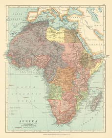
Africa. French West/Equatorial. Tanganyika Belgian Congo. STANFORD c1925 mapJasper524.5(9.9k)See Sold PriceFeb 28, 2024