SoldAtlas of Plymouth County, 1879, published by Geo.H. Walker and Co. 61 Hanover St, Boston. 92 pages plus 6 pages in the back of advertising. Numerous maps and plates of Plymouth County. 18 1/2" x 15". Appears to be in good, as-found condition with noSee Sold Price
SoldAtlas of Plymouth County Massachusetts 1879This nice vintage atlas reads on the front page Atlas of Plymouth County Massachusetts complied from recent and actual surveys and records under the direction of the publishers, published by Geo. H. WSee Sold Price
Sold1879 BOUND ATLAS OF PLYMOUTH COUNTYAtlas of Plymouth County, Massachusetts, 1879, published by George H. Walker & Co., Boston, Mass. Rough condition covers and detached, Missing some front pages. Loose first 10 pages. Hand coloredmaps.See Sold Price
SoldBOUND ATLAS OF PLYMOUTH COUNTY 1879 PUBLISHEDBY GEORGE WALKER & CO., BOSTON; 92 PAGES WITH 5 PAGES OF ADS IN THE REAR; 18" X 15"; HAS ORIGINAL CLOTH BINDING WITH GILDED LETTERING; SPINE IS BROKEN AND THE FRONT IS DETACHED; FRONT PAGE HAS BEEN FOSee Sold Price
SoldBOUND 1903 ATLAS OF PLYMOUTH COUNTY AND TOWN OFCOHASSET, NORFOLK COUNTY, L. J. RICHARDS CO.; APPROXIMATELY 81 PRINTED PAGES; 22 1/2" X 17"; SOME CREASED PAGES; TORN, CHIPPED AND FOLDED CORNERS; WITH FOLD-OUT MAP OF PLYMOUTH, WHITMAN AND KINGSTON;See Sold Price
SoldBOUND ATLAS OF PLYMOUTH COUNTY TOGETHER WITHTOWN OF COHASSET, NORFOLK COUNTY, MASS, 1903, THE L.J. RICHARDS CO, SPRINGFIELD, MASS. 36 OF THE 37 MAPS ARE PRESENT. MAP 22 IS MISSING. MAP 15, HANSON IS DETACHED AND BADLY DAMAGED. MAP 19, HULL HASSee Sold Price
Sold1879 BOUND "ATLAS OF PLYMOUTH COUNTY"BY GEORGE H. WALKER & CO.; GOOD OVERALL CONDITION; PAGES 9, 12, 13, 16, 24, 28, 37, 38, 39, 40, 76 ARE INTENTIONALLY LEFT BLANK.See Sold Price
SoldAtlas of Plymouth CountyGeorge H. Walker and Co., Boston, atlas of Plymouth County, dated 1879, with center fold panorama of Nantasket beach, 18 1/2" h x 15" w. Provenance: MA estate.See Sold Price
Sold3 UNFRAMED MAPS TO INCLUDE TWO 1903 MAPS OFTHE VILLAGE OF MATTAPOISETT, SIGHT SIZE 22" X 31 1/4", FROM A 1903 ATLAS OF PLYMOUTH COUNTY. ONE SHOWS VERY MINOR HOLES. ALONG WITH A MAP OF THE TOWN OF ROCHESTER, MASS., FROM A PLYMOUTH COUNTY MAP BOSee Sold Price
(MASSACHUSETTS.) Walker, George H., & Co. Atlas of(MASSACHUSETTS.) Walker, George H., & Co. Atlas of Plymouth County, Massachusetts. Profusion of hand-colored lithographed mapsheets and views (complete). Folio, 18x15 inches, publisher's gilt-stampedSee Sold Price
3 UNFRAMED MAPS TO INCLUDE TWO 1903 MAPS OF THEVILLAGE OF MATTAPOISETT, SIGHT SIZE 22" X 31 1/4" FROM A 1903 ATLAS OF PLYMOUTH COUNTY. ONE SHOWS VERY MINOR HOLES. ALONG WITH A MAP OF THE TOWN OF ROCHESTER, PLYMOUTH COUNTY, FROM PLYMOUTH COUNTY MAPSee Sold Price
SoldGEORGE WALKER ATLAS BOOK OF PLYMOUTH COUNTY:Ca. 1879. Atlas of Plymouth County, Massachusetts, 1879 First Edition published by George H. Walker & Co. Boston, Mass. Consists of 92 pages along with four pages of lists of Manufacturers and MerchanSee Sold Price
SoldPLYMOUTH COUNTY 1879 HAND COLORED ATLAS BOOK:Atlas of Plymouth County, Massachusetts, 1879 First Edition published by George H. Walker & Co. Boston, Mass. Consists of 92 pages along with four pages of lists of Manufacturers and Merchants. IncludSee Sold Price
SoldMASSACHUSETTS ATLASES 1879 & 1891Two New England atlases, one atlas of Massachusetts 1891, one atlas of Plymouth County 1879, two journals of Stanley Alger, who worked for the government during World War II, photo of family homesteadSee Sold Price
Sold19TH C. BOUND ATLAS; MAPS OF TOWNS Atlas of Plymouth19TH C. BOUND ATLAS; MAPS OF TOWNS Atlas of Plymouth County, Massachusetts, 1879, published by George H. Walker & Co., Boston, Mass., 92 pgs; along with four pages of lists of Manufacturers and MerchaSee Sold Price
Plymouth CountyTitle: Plymouth County Date: 1871 Cartographer: GRAY, ORMANDO W. Publisher: STEDMAN, BROWN & LYON Size: 23Height - 15Width 66-67 from Walling & Gray's "Official topographical atlas of Massachusetts, fSee Sold Price
Sold1857 Wall Map of Plymouth County, Henry Walling19th C. wall map of Plymouth County, Henry Francis Walling 1857. Map depicts geography of Plymouth County in color with inset detailed maps of individual towns and engravings of noted landmarks. Map iSee Sold Price
Sold1891 Map of Plymouth CountyOriginal 1891 Walker's Map showing Kingston, Plymouth, Bourne, and parts of Middleboro, Halifax, Rochester and Sandwich. Major roads and railways of the day are shown. 31 x 23See Sold Price
Plymouth County Maps, MA Town Histories (7pc)Collection of Massachusetts Town Histories (5pc) and vintage maps, including: (1) "History of the Town of Carver, Massachusetts: Historical Review 1637 to 1910" by Henry S. Griffith (New Bedford, MA:See Sold Price
Sold1891 Map of Plymouth CountyOriginal 1891 Walker’s Map showing Kingston, Plymouth, Bourne, and parts of Middleboro, Halifax, Rochester and Sandwich. Major roads and railways of the day are shown. 31” x 23”See Sold Price
SoldANTIQUE MAP OF MARION PLYMOUTH COUNTY, MASS 1855FRAMED ANTIQUE MAP OF MARION PLYMOUTH COUNTY, MASS., 1855, FRAME 30 X 25 INCHES, SITE 23 X 18 INCHESSee Sold Price
Sold1891 Map of Plymouth CountyOriginal 1891 Walker’s Map showing Kingston, Plymouth, Bourne, and parts of Middleboro, Halifax, Rochester and Sandwich. Major roads and railways of the day are shown. 31†x 23â€See Sold Price
SoldEarly 20th century map of Cape CodColorful early twentieth century map of Cape Cod. All major attractions are listed. Map shows Plymouth and Barnstable County. Framed. Overall dimensions 28 inches x 39 inches.See Sold Price
SoldGROUP LOT OF MAPSINCLUDING - ROAD MAP AROUND NEW YORK, TROLLEY MAP OF PLYMOUTH, 1902 ORANGE COUNTY, NEW YORK - 19488 PHILADELPHIA STREET GUIDE AND MORESee Sold Price
Lot of Six Mixed Atlas Box Cars-HO Scale-New in BoxJM Hobby Supply and Railroad Artifact Auctions4.4(126)See Sold PriceFeb 25, 2024
Lot of Six Mixed Atlas Cabooses-HO Scale-New in BoxJM Hobby Supply and Railroad Artifact Auctions4.4(126)See Sold PriceFeb 25, 2024
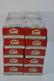
Chesapeake and Ohio RR 10-pack Atlas 2 Bay Open Hoppers-HO Scale-New in BoxJM Hobby Supply and Railroad Artifact Auctions4.4(126)See Sold PriceFeb 25, 2024
ATLAS of ANTIENT GEOGRAPHY by SAMUEL BUTLER 1843John McInnis Auctioneers,LLC4.6(502)See Sold PriceFeb 24, 2024
General Books - Nicolson - The Counties of Britain - A Tudor Atlas by John SpeedTimeLine Auctions Ltd.4.5(183)See Sold PriceMar 08, 2024
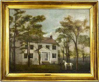
Early American Montgomery County Maryland Oil Painting on Canvas Gilt FramedChina Luban Art & Antique, Inc.4.4(78)See Sold PriceFeb 24, 2024
Rand McNally & Co's New Ideal State and County Survey and Atlas 1911North American Artifact Auctions4.6(182)See Sold PriceApr 20, 2024
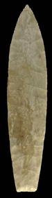
5 5/16" Agate Basin. Pike County, Illinois. Partain COATony Putty Artifacts4.7(404)See Sold PriceMar 09, 2024
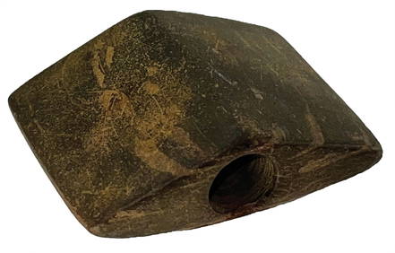
2 9/16" Archaic Bannerstone. Logan County, Kentucky.Tony Putty Artifacts4.7(404)See Sold PriceMar 09, 2024
4" Clovis. Liberty County, Montana. Black Chert. Putty COATony Putty Artifacts4.7(404)See Sold PriceMar 09, 2024
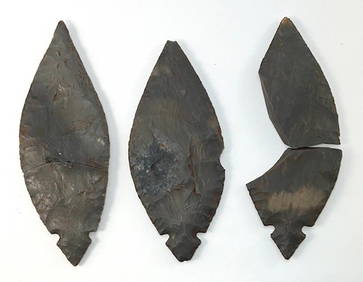
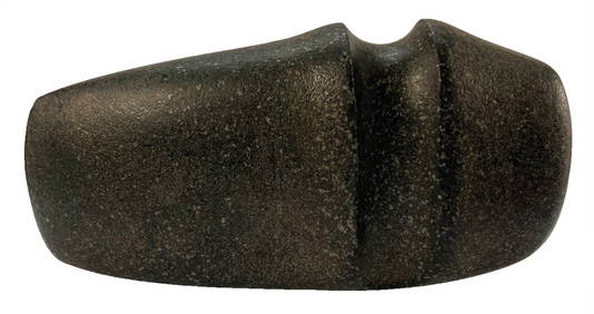
3 Piece Turkey Tail Cache. Found in Jay County, Indiana.Tony Putty Artifacts4.7(404)See Sold PriceMar 09, 2024
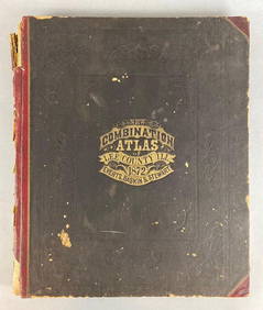
1872 New Combination Atlas of Lee County Illinois BookMatthew Bullock Auctioneers4.7(1.8k)See Sold PriceFeb 24, 2024
1905 20th Century Atlas of Boone County IllinoisMatthew Bullock Auctioneers4.7(1.8k)See Sold PriceFeb 24, 2024
Model Train Sets in HO Scale, From Athearn, AHM, Atlas, and RoundhouseCain Modern Auctions4.4(44)See Sold PriceFeb 28, 2024
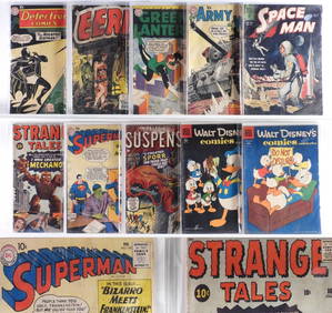
10PC Atlas DC Dell Golden Silver Age Comics GroupBruneau & Co. Auctioneers4.5(491)See Sold PriceFeb 24, 2024