SoldAtlas of 17th Century Antique Maps - 45Hand made atlas consisting of 45 17th Century European maps. All hand drawn and hand colored. Maps by Blaeuw, Hondius, Homann et al. One map carries a date of 1610. All maps laid on paper. Book 16.5"See Sold Price
SWEDEN 17th CENTURY ANTIQUE MAPSome wear. Size 20 by 17" (541) PA residents please add sales tax. Please see my other auctions Reserve: $135.99 Shipping: Domestic: Flat-rate of $6.00 to anywhere within the contiguous U.S. ISee Sold Price
17th century antique MAP OF SCANDINAVIA & NORTH OFSize 14 by 16 1/4" Very good condition. Some minor repaired tears on the margins. (551) Reserve: $183.99 Shipping: Domestic: Flat-rate of $6.00 to anywhere within the contiguous U.S. International: FoSee Sold Price
SoldMap of the Americas 1614 Copper Plate Engraving 17C MapCopper Plate Engraved 17C Map of The Americas. The 17th century antique map title is "Americae Nova Descriptio" and dated 1614. A copperplate engraving by Abraham Goos with hand coloring. The 17th cenSee Sold Price
Tassin: Antique Map of Calais, France, 1636Title/Content of Map: Fine 17th century antique map of Calais, France Date Printed: 1636 Cartographer: Tassin, Christophe Nicholas Size (inches): 6 x 4 Full contemporary hand color Antique engraved viSee Sold Price
L'Europa. Europe. DE ROSSI 1677 old antique vintage map plan chartTITLE/CONTENT OF MAP: L'Europa [Europe] DATE PRINTED: 1677 IMAGE SIZE: Approx 44.0 x 56.5cm, 17.25 x 22.25 inches (Large) TYPE: Antique 17th century folio atlas map CONDITION: Good; suitable for framiSee Sold Price
L'Europa. Europe. DE ROSSI 1677 old antique vintage map plan chartTITLE/CONTENT OF MAP: L'Europa [Europe] DATE PRINTED: 1677 IMAGE SIZE: Approx 44.0 x 56.5cm, 17.25 x 22.25 inches (Large) TYPE: Antique 17th century folio atlas map CONDITION: Good; suitable for framiSee Sold Price
L'Asia. China. Mughal Empire. DE ROSSI / SANSON 1677 old antique map chartTITLE/CONTENT OF MAP: L'Asia [Asia] DATE PRINTED: 1677 IMAGE SIZE: Approx 42.5 x 57.0cm, 16.75 x 22.5 inches (Large) TYPE: Antique 17th century folio atlas map CONDITION: Good; suitable for framing. PSee Sold Price
Antique Maps 17th Century ParisAntique Maps. Appear to be etched in the 17th Century. Map edges are quite worn, one has a large chip out of the upper right. Various makers. This item is from the estate of a gentleman from Gaton LamSee Sold Price
Antique Map 17th Century Maps Lot Of 5Antique Maps.Lot of 5 maps are by various makes and have a range of condition issues. This item is from the estate of a gentleman from Gaton Lamps on Melrose Ave. Gaton Lamps worked on the interior ofSee Sold Price
SoldMap, Marchionatus Misniae una cum VoitlandiaAn antique map. 17th century, c.1630. Titled Marchionatus Misniae una cum Voitlandia by Dutch Cartographer, atlas maker and publisher Henricus Hondius. A copperplate engraving in full color. The sheetSee Sold Price
SoldMap, Comitatus Marchia et Ravensberg, BlaeuAn antique map. 17th century. Titled Comitatus Marchia et Ravensberg by Dutch Cartographer, atlas maker and publisher Willem Janszoon Blaeu (1571-1638). A copperplate engraving in full color. The sheeSee Sold Price
SoldMap, Principatus Anhaldinus et MagdeburgensisAn antique map. 17th century, c.1630, Titled Principatus Anhaldinus et Magdeburgensis, Archiepiccopatus, by Dutch Cartographer, atlas maker and publisher Jodocus Hondius (1563-1612). A copperplate engSee Sold Price
SoldJOHN SPEED 1676 New Description of Carolina Old 17C MapJohn Speed 17C New Description of Carolina Map. The early antique 17th century map is titled John Speed New Description of Carolina, London 1676. A copper plated engraving by Francis Lamb with hand coSee Sold Price
Antique 17th Century French MapsAntique Map. Two 17th century French maps. As Found. This item is from the estate of a gentleman from Gaton Lamps on Melrose Ave. Gaton Lamps worked on the interior of the White House with Jackie KennSee Sold Price
SoldVISSCHER. Portugalliae et Algarbiae RegnaVISSCHER, Nicolaum. Portugalliae et Algarbiae Regna. 17th century. Engraved map, hand-coloured. Framed. 45.8cm x55.7cm (18" x 22")See Sold Price
A Mapp of the county of Cornwal; With its Hundreds by Richard Blome 1673Title: A Mapp of the county of Cornwal; With its Hundreds by Richard Blome 1673 Description: A Mapp of the county of Cornwal; With its Hundreds' by Richard Blome (1673). Antique 17th century map, 25.0See Sold Price
Antique map Scotia Regnum. 17th century. Hand colored.Antique map Scotia Regnum. 17th century. Hand colored. A few minor damage at the rim. Size: 53 x 51 cm. In reasonable / good condition.See Sold Price
Beautiful antique 17th century colored map. EpiscopatusBeautiful antique 17th century colored map. Episcopatus Hildesiensis Gerhard Lust. Arenholdum Germany. Geographis Nurimbergce. Rare version with beautiful colored engravings on paper. Size: 56 x 48 cmSee Sold Price
SoldVisscher: Antique Map of Africa, 1670Title: Africæ Accurata Tabula. 17th century Visscher map of Africa Map maker: Nicolas Visscher Place and Year: Amsterdam, c. 1670 Dimensions: 43.5 x 54 cm (17¼ x 21¼ in) Technique: Copperplate engrSee Sold Price
Blaeu: Antique Map of Italy & Islands, 1635Title: "Nova Italiae Delineatio", Beautiful mid-17th century hand-colored map of Italy and surrounding islands Map maker: Willem Janszoon Blaeu Place and Year: Amsterdam, c. 1635 Dimensions: 51.0 x 59See Sold Price
SoldMorisot: Antique Map of North America, 1643Title: Americae Septentrionalis Circuitus. Mid-17th century French copperplate map with cartographic myths Map maker: Claude Bartholomy Morisot Place and Year: Dijon, 1643 Dimensions: 16.6 x 13.5 cm (See Sold Price
SoldAntique Map Of Italian Papal States Near RomeProbably 17th Century, Hand Colored Engraving With Patrimonio Di S. Pietro Sabina Et Ducato Di Castro, Sight 14 X 18 Inches, Later Frame 19 X 23 X 1 Inches. See Photos For Condition.See Sold Price
SoldJanssonius: Antique Map of Portugal, 1645Title: Portugallia et Algarbia quae olim Lusitania. Attractive mid-17th century map of Portugal Map maker: Jan Janssonius Place and Year: Amsterdam, [c.1645] Dimensions: 38.5 x 49.5 cm (15¼ x 19½ inSee Sold Price
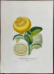
Risso - Lemon or Citrus Fruit. 73Trillium Antique Prints & Rare Books4.5(30)See Sold PriceFeb 24, 2024
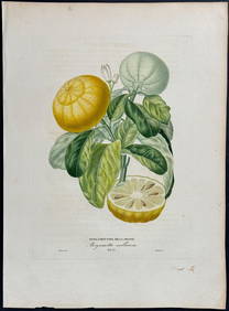
Risso - Lemon or Citrus Fruit. 71Trillium Antique Prints & Rare Books4.5(30)See Sold PriceFeb 24, 2024
1822 MAP of LEEWARD ISLANDS GEOGRAPHICAL STATISTICAL HISTORICAL antique 17.5x22"Jasper524.5(9.8k)See Sold PriceFeb 27, 2024
WEST AFRICA Niger/Gambia rivers tribes towns. 'Pays des Negres'. MALLET 1683 mapJasper524.5(9.8k)See Sold PriceFeb 28, 2024
WEST AFRICA. People of Guinea. 'Peuples de Guinée'. Costume. MALLET 1683 printJasper524.5(9.8k)See Sold PriceFeb 28, 2024
WEST AFRICA. Guinea. Nigeria Ghana Benin Togo Sierra Leone. MALLET 1683 mapJasper524.5(9.8k)See Sold PriceFeb 28, 2024
WEST CENTRAL AFRICA. Congo Angola Gabon Cameroon Sao Tome. MALLET 1683 old mapJasper524.5(9.8k)See Sold PriceFeb 28, 2024
NORTH AFRICA. 'Biledulgerid', a former North African country. MALLET 1683 mapJasper524.5(9.8k)See Sold PriceFeb 28, 2024
COLONIES FRANÇAISES en AFRIQUE. Africa Sénégal Madagascar. LEVASSEUR c1850 mapJasper524.5(9.8k)See Sold PriceFeb 28, 2024
WEST AFRICA/MAGHREB Tribes Garamantes Getgulie 'Ancienne Libye'. MALLET 1683 mapJasper524.5(9.8k)See Sold PriceFeb 28, 2024
Johnson's Africa. Colonies & tribes. Liberia Nile Delta Cape Colony 1866 mapJasper524.5(9.8k)See Sold PriceFeb 28, 2024
MALLET. Description de l'Univers. Africa. Volume 3 title page. MALLET 1683Jasper524.5(9.8k)See Sold PriceFeb 28, 2024
NORTH AFRICA. Barbary. Morocco Tunisia Libya Egypt. 'Barbarie'. MALLET 1683 mapJasper524.5(9.8k)See Sold PriceFeb 28, 2024
NORTH AFRICA. Morocco Tunisia Libya. 'Mauritanie'. Malta Melita. MALLET 1683 mapJasper524.5(9.8k)See Sold PriceFeb 28, 2024
NUBIA. 'Nubie'. Nile Valley. Sudan Ethiopia Egypt. MALLET 1683 old antique mapJasper524.5(9.8k)See Sold PriceFeb 28, 2024
SUB-SAHARAN AFRICA. 'Ancienne Ethiopie'. Ancient Ethiopia. MALLET 1683 old mapJasper524.5(9.8k)See Sold PriceFeb 28, 2024
West Africa. Sahara caravan routes. Tribes Kingdoms Empires. LIZARS 1842 mapJasper524.5(9.8k)See Sold PriceFeb 28, 2024
Afrique Ancienne. Ancient North Africa. MALTE-BRUN c1871 old antique map chartJasper524.5(9.8k)See Sold PriceFeb 28, 2024
Lot of 16 Portraits - Raphael - Michael Stecher Walther - Peder Oxe - Albrecht, archduke of AustriaProverde Auctions4.3(3)See Sold PriceFeb 28, 2024
Set of 6 Lithograph Prints of Dalarna Cabinets, Nordic Textiles, and Baroque Elegance - 1800sProverde Auctions4.3(3)See Sold PriceFeb 28, 2024