Antique Map Showing Indian Reservations of the UniAntique Map Showing Indian Reservations of the United States, 1902. Dimensions: 21 ½ x 33 ½ inches showing; 32 x 44 inches overall as framed. This is an interesting map of the United States at the tSee Sold Price
SoldAN ANTIQUE MAP, "Map showing Indian Reservations withinAN ANTIQUE MAP, "Map showing Indian Reservations within the limits of the United States," 1889, color lithograph on paper, "Compiled under the direction of the Hon. T.J. Morgan, Commissioner of IndianSee Sold Price
SoldNative American/Western U.S. Expedition Ephemera1st item: "Map Showing the Location of the Indian Reservations Within the Limits of the United States and Territories" compiled from the Official and other Authentic Sources, under the Direction of thSee Sold Price
SoldAntique Map of Oregon & Indian Reservations, 1903Title/Content of Map: 'Oregon' State map showing counties & Indian reservations Date Printed: 1903 Image Size: Approx 27.5 x 39.0cm, 10.75 x 15.25 inches (Large); Please note that this is a folding maSee Sold Price
SoldMap showing Indian Reservations, Norris Peters CoTitle: Map showing Indian Reservations within the limits of the United States.Photo-lithograph, 1904. Published by the Norris Peters Co., Washington, D.C. Image size 21 1/8 x 33 3/16" (53.6 x 84.2 cmSee Sold Price
Map Showing Indian Reservations in the United StatesTitle/Content of Map: Map Showing Indian Reservations in the United States West of the 84th Meridian and Number of Indians Belonging Thereto 1882 Date: 1882 Cartographer: Anonymous Size: 13Height - 17See Sold Price
SoldTwo Late 19th C. Maps Showing Indian Reservationsboth "Compiled Under The Direction Of The Hon. T.J. Morgan", dated 1890 and 1891, both being 23 5/8" x 34 3/4"See Sold Price
SoldOriginal 1895 Indian Reservation MapThis is an original Native American Indian reservation map from 1895. The map is marked "Map Showing Indian Reservations within the Limits of the United States Compiled Under the Direction of the Hon.See Sold Price
Sold1896 Map of Indian Reservations in the US -- MapTitle/Content of Map: 1896 Map of Indian Reservations in the US -- Map Showing Indian Reservations within the Limits of the United States Compiled under the Direction of the Hon. D. M. Browning ComissSee Sold Price
Sold1899 Jones Map U.S. Indian Reservations"Map showing Indian Reservations within the limits of the United States compiled under the direction of the Hon. W. A. Jones Commissioner of Indian Affairs 1899". Includes inset maps of Alaska, CalifoSee Sold Price
Sold1899 Map of Indian Reservations in the US -- MapTitle/Content of Map: 1899 Map of Indian Reservations in the US -- Map Showing Indian Reservations within the Limits of the United States Compiled under the Direction of W. A. Jones Comissioner of IndSee Sold Price
SoldOklahoma, Indian Terr., Indian Res, N.M.T. MapsProposed state of Oklahoma. General Land Office map 1906; Progress of survey and subdivision, Idnian Territory 1896; map showing Indian Reservations within the limits of the US - 1889; and map of theSee Sold Price
Sold1897 Map of Indian Reservations in the US -- MapReserve Reduced! Title/Content of Map: 1897 Map of Indian Reservations in the US -- Map Showing Indian Reservations within the Limits of the United States Compiled under the Direction of W. A. Jones CSee Sold Price
Sold1885 Map of Indian Reservations in the US -- MapReserve Reduced! Title/Content of Map: 1885 Map of Indian Reservations in the US -- Map Showing Indian Reservations within the Limits of the United States Compiled under the Direction of the Hon. JohnSee Sold Price
SoldOFFICE OF INDIAN AFFAIRS HISTORICAL AMERICAN INDIANOFFICE OF INDIAN AFFAIRS HISTORICAL AMERICAN INDIAN RESERVATIONS MAP, title in circular cartouche to lower right corner "MAP / SHOWING / INDIAN RESERVATIONS / WITHIN THE LIMITS OF THE / UNITED STATESSee Sold Price
Sold1894 Map of Indian ReservationsTitle: Map Showing Indian Reservations Within the Limits of the United States, Compiled Under the Direction of Hon. D.M. Browning. Commissioner of Indian Affairs, 1894 Author: ** Description: Photo-liSee Sold Price
SoldNative American Nations Map, lithograph, 24 x 35 inNative American Nations Map lithograph inscribed "Map Showing Indian Reservations within the limits of the United States compiled under the direction of the Hon. T.J. Morgan Commissioner of Indian AffSee Sold Price
SoldMap of the Indian reservations 1882Heading: (Indian Reservations) Author: Title: Map Showing Indian Reservations in the United States West of the 84th Meridian and Number of Indians belonging thereto. Place Published: [Washington] PubSee Sold Price
Sold1895 Map of Indian ReservationsTitle: Map Showing Indian Reservations Within the Limits of the United States, Compiled Under the Direction of Hon. D.M. Browning. Commissioner of Indian Affairs, 1895 Author: Browning, D.M. DescriptiSee Sold Price
Sold1902 map of Indian ReservationsHeading: (United States - Indian Reservations) Author: Title: Map Showing Indian Reservations Within the Limits of the United States, Compiled Under the Direction of Hon. W.A. Jones, Commissioner ofSee Sold Price
Paul Brodie: Antique Map of Indian Reservations, 1885Title: Map of Indian Reservations by Paul Brodie Date: 1885 Medium: Lithograph Dimensions (in): 34 x 23.5 Condition: Great Condition No Reserve: This lot starts at $1 and has no reserve as a courtesySee Sold Price
Sold7 folding maps: Indian Reservations (1892)-1920.[Native Americans/Indian Reservation Maps] 7 large folding maps showing locations of Indian reservations. ++ MAP SHOWING THE INDIAN RESERVATIONS WITHIN THE LIMITS OF THE UNITED STATES UNDER THE DIRECTSee Sold Price
SoldNew MexicoTitle: New Mexico Publication Date: 1885 Cartographer: CRAM, GEO. F. Publisher: CRAM, GEO. F. Brief Descriptions: Map showing counties, towns, townships, Indian reservations, railroads and topography.See Sold Price
SoldAN ANTIQUE MAP, "Indian Territory Showing TownsitesAN ANTIQUE MAP, "Indian Territory Showing Townsites Approved to June 30, 1902," NEW YORK, color engraving on paper, "The Ninth Annual Report Commission to the Five Civilized Tribes," Exhibit 6, preparSee Sold Price
Rand McNally Railroad Map of Washington-1906JM Hobby Supply and Railroad Artifact Auctions4.4(127)See Sold PriceFeb 24, 2024
18TH C. ANTIQUE MAP: FRENCH & INDIAN WAR, FRAMEDThomaston Place Auction Galleries4.4(394)See Sold PriceFeb 24, 2024
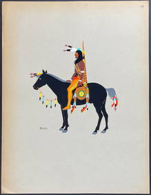
Kiowa Indian Art - Mopope: Kiowa Warrior on HorsebackTrillium Antique Prints & Rare Books4.5(33)See Sold PriceFeb 24, 2024
Kiowa Indian Art - Mopope: Kiowa Warrior and wifeTrillium Antique Prints & Rare Books4.5(33)See Sold PriceFeb 24, 2024
Karl Bodmer - A Young Mandan Indian. 24Trillium Antique Prints & Rare Books4.5(33)See Sold PriceFeb 24, 2024
Karl Bodmer - Assinboin Indians. 32Trillium Antique Prints & Rare Books4.5(33)See Sold PriceFeb 24, 2024
Hist. of Indian wars of the Far West - Massacres of the MountainsJasper524.5(9.9k)See Sold PriceFeb 27, 2024
SECOND WORLD WAR AFRICA. European colonies & German mandates 1940 old mapJasper524.5(9.9k)See Sold PriceFeb 28, 2024
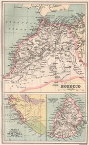
MOROCCO LIBERIA & MAURITIUS. Sierra Leone. BARTHOLOMEW 1886 old antique mapJasper524.5(9.9k)See Sold PriceFeb 28, 2024
AFRICA. Political Map of showing International Boundaries 1936 old vintageJasper524.5(9.9k)See Sold PriceFeb 28, 2024
Central Africa. Map showing great forest traversed by Mr Stanley, 1890Jasper524.5(9.9k)See Sold PriceFeb 28, 2024
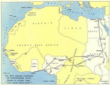
West Africa WW2 Nigeria Sudan Egypt. Takoradi air reinforcement route 1954 mapJasper524.5(9.9k)See Sold PriceFeb 28, 2024
WEST AFRICA showing early explorers' routes & Mountains of Kong. SDUK 1844 mapJasper524.5(9.9k)See Sold PriceFeb 28, 2024
Operation Torch Nov 1942-May 1943. World War 2. Western Mediterranean 1966 mapJasper524.5(9.9k)See Sold PriceFeb 28, 2024
Blackie (Pub) 1882 Folio Map. East Indies - Indian ArchipelagoAlbion Auctions4.7(341)See Sold PriceMar 01, 2024