SoldAntique Map : Plan De Bayonne - 1901Antique Map : Plan De Bayonne - 1901 Size : 19" x 15"See Sold Price
Antique Map : Plan De Bayonne - 1901Antique Map : Plan De Bayonne - 1901 Size : 19" x 15"See Sold Price
Antique Map : Plan De Bayonne - 1901Antique Map : Plan De Bayonne - 1901 Size : 19" x 15"See Sold Price
SoldAntique Map: Plan de la Rade de Gedda situee de la CoteChart of the area around city of Gedda in the Red Sea. D'AprŠs De Mannevillette (1707-1780) was one of Franc's first hydrographers. When the first edition of his Atlas Le Neptune Oriental (containiSee Sold Price
SoldMap Nouveau Plan De Cartagene, 1741Antique map titled Nouveau Plan De Cartagene, Avec les Dernieres Attaques des Forts, Par L'Amiral Vernon, Suivant l'original Anglois 1741, avec permission de M. de Maurepas. Rare Le Rouge plan of theSee Sold Price
SoldANTIQUE MAP VENICE CARTE DU PLAN DE VENISEFramed, uncolored map of Carte Du Plan de Venise, etc. detailed nobler families, post Napoleonic era. Map measures 18 1/2" wide x 15 1/2" tall and framed is 24" wide x 21" tall. Some foxing on map. NoSee Sold Price
SoldANTIQUE MAP VENICE CARTE DU PLAN DE VENISEFramed, uncolored map of Carte Du Plan de Venise, etc. detailed nobler families, post Napoleonic era. Map measures 18 1/2" wide x 15 1/2" tall and framed is 24" wide x 21" tall. Some foxing on map. NoSee Sold Price
SoldFramed Antique French Map "La Judee Plan de Jerusalem"Framed Antique French Map "La Judee Plan de Jerusalem" {Dimensions of frame 25 x 33 inches; sight 23 x 19 inches} [Creasing; not examined out of frame]See Sold Price
de Fer: Antique Map Plan of Antwerp, Belgium, 1700Map: Anvers or Antwerp, Belgium. "Anvers, Antwerpen en Flamand Belle et Grande Ville de Pais Bas . . . (Antwerp)" Date Printed: 1700 Cartographer: Nicolas de Fer Size: 11 x 8 inches Condition: Good coSee Sold Price
SoldAntique French Map of St. AugustineAntique French Map of St. Augustine, "Plan de la Ville et Port de St. Augustin", late 18th/early 19th c., hand-colored engraved map, sight 8 1/2 in. x 12 in., framed. Provenance: Estate of Faith K. TiSee Sold Price
SoldTwo Maps of ParisTwo Antique Maps of Paris , incl.: "Troisieme Plan de la Ville de Paris", 1705, by Nicolas de la Mare, showing medieval Paris, 16 1/2 in. x 20 1/2 in.; and "Nouvelle Description du Territoire et BanliSee Sold Price
SoldGroup of Assorted Antique Maps of Vienna AustriaGroup of Assorted Antique Maps of Vienna, Austria including 'Plan de la Ville et des Fauxbourgs de Vienne,''Derivation du Danube pres de Vienne,' 'Erz~Herzogthum Oesterreich:Unter Der Enns 1853,' 'DieSee Sold Price
Group of Assorted Antique Maps of Vienna AustriaGroup of Assorted Antique Maps of Vienna, Austria including 'Plan de la Ville et des Fauxbourgs de Vienne,''Derivation du Danube pres de Vienne,' 'Erz~Herzogthum Oesterreich:Unter Der Enns 1853,' 'DieSee Sold Price
SoldAntique Map, AlexandrieAntique Map, "Alexandrie; Plan General Des Deux Ports, De la Ville des Arabes, leve par les Ingenieurs ae l'Armee d'Orient," copper engraved map, overall: 27.25"h x 40.25"wSee Sold Price
SoldPlan de la Ville du Cap, antique map, 1731Plan de la Ville du Cap, antique map, 1731, Hippolyte-Louis Guerin, Paris, "Plan de la Ville du Cap, a la Cote Septentrional de Saint Domingue", hand-colored engraving on paper, 8"h x 11"w (sight), 12See Sold Price
de Fer: Antique Map, City Plan of Barcelona, 1705Title/Content of Map: 'Barcelonne [Barcelona]' Fortifed town/city plan. Spain. Date Printed: 1705 Image Size: Approx 19.0 x 31.5cm, 7.5 x 12.25 inches (Medium) Type: Early 18th century copperplate mapSee Sold Price
de Fer: Antique Map, City Plan of Brussels, 1705Title/Content of Map: 'Bruselles [Brussels/Bruxelles]' Fortified town/city plan. Date Printed: 1705 Image Size: Approx 20.5 x 33.0cm, 8 x 13 inches (Large) Type: Early 18th century copperplate map ConSee Sold Price
de Fer: Antique Map, City Plan of Frankfurt, 1705Title/Content of Map: 'Francfort [Frankfurt am Main]' Fortified town/city plan. Date Printed: 1705 Image Size: Approx 22.0 x 31.0cm, 8.5 x 12.25 inches (Large) Type: Early 18th century copperplate mapSee Sold Price
de Fer: Antique Map, City Plan of Puigcerda, 1705Title/Content of Map: 'Puicerda [Puigcerda]' Fortifed town/city plan. Spain. Date Printed: 1705 Image Size: Approx 20.0 x 26.0cm, 7.75 x 10.25 inches (Medium) Type: Early 18th century copperplate mapSee Sold Price
L'Irlanda o'vero Hibernia. Ireland. DE ROSSI 1689 old antique map plan chartTitle: L'Irlanda o'vero Hibernia. Ireland. DE ROSSI 1689 old antique map plan chart Description: L'Irlanda o'vero Hibernia [Ireland, or Hibernia] by Published by Giovanni Giacomo de Rossi. Antonio BarSee Sold Price
Environs de Paris by ROBERT DE VAUGONDY 1753 old antique map plan chartTITLE OF MAP (NOT PRINTED ON THE PAGE):'Environs de Paris. Par le Sr. Robert Geographe ordinaire du Roi. Avec Privilege' DATE PRINTED: 1753 IMAGE SIZE: Approx 50.0 x 61.5cm, 19.75 x 24.25 inches (LargSee Sold Price
Bellin: Antique French Map Plan of Boston, 1757Title/Content of Map: Antique French Map and Plan of Boston, Massachusetts. Plan de la Ville de Boston et ses Environs Date Printed: 1757 Cartographer: Bellin, Jacques Nicolas Size (inches): 10 x 6 OnSee Sold Price
SoldBellin: Antique Map of Early Boston, 1757Title/Content of Map: Plan de la Ville de Boston et ses Environs Cartographer: Bellin Place & Date: Paris / 1757/1760 Size: 10 5/8" x 6 3/8" Condition: b&w; light overall age toning; a few spots in thSee Sold Price
Tirion: Antique Map Plan of New Orleans, 1765Map: Grondvlakte van Nieuw Orleans, de Hoofstad van Louisiana Cartographer: Tirion Place & Date: Amsterdam / 1765 Size: 10 1/2" x 6 1/2" Condition: b & w; light overall age toning; with folds as issueSee Sold Price
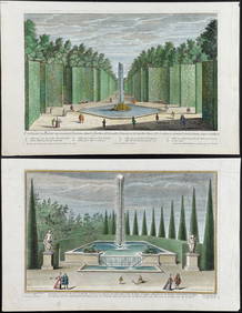
Demortain - 4 Fountain & Garden EngravingsTrillium Antique Prints & Rare Books4.5(30)See Sold PriceFeb 24, 2024
COLONIAL GABON & CONGO. Afrique équatoriale française. Brazzaville plan 1929 mapJasper524.5(9.8k)See Sold PriceFeb 28, 2024
Plan du Portendic, appellé aussi…' Portendick Mauritania. BELLIN 1746 old mapJasper524.5(9.8k)See Sold PriceFeb 28, 2024
FRENCH SUDAN (Now Mali). Soudan Français. Bamako city plan de la ville 1929 mapJasper524.5(9.8k)See Sold PriceFeb 28, 2024
Plan de la Baye & Isle d'Arguim'. Mauritania. Arguin island. BELLIN 1746 mapJasper524.5(9.8k)See Sold PriceFeb 28, 2024
FRENCH SUDAN (Now Mali). Soudan Français. Bamako city plan de la ville 1938 mapJasper524.5(9.8k)See Sold PriceFeb 28, 2024
FRENCH SUDAN (Now Mali). Soudan Français. Bamako city plan de la ville 1931 mapJasper524.5(9.8k)See Sold PriceFeb 28, 2024
COLONIAL GABON & CONGO. Afrique équatoriale française. Brazzaville plan 1938 mapJasper524.5(9.8k)See Sold PriceFeb 28, 2024
Plan de Fort d'Arguim'. Mauritania. Arguin fort. BELLIN 1746 old antique mapJasper524.5(9.8k)See Sold PriceFeb 28, 2024
Barthelemy, Jean 1790 Map. Greece - Essa sur la Bataille de PlateeAlbion Auctions4.6(341)See Sold PriceMar 01, 2024
Barthelemy, Jean 1790 Map. Greece - Plan de L'AcademieAlbion Auctions4.6(341)See Sold PriceMar 01, 2024
Barthelemy, Jean 1790 Map. Greece - Essai sur les Environs de DelphesAlbion Auctions4.6(341)See Sold PriceMar 01, 2024
Jean-Francois de Neufforge (1714 - 1791) - Set of 15 Architecture Prints - Plan de l' EdificeProverde Auctions4.3(3)See Sold PriceFeb 28, 2024
Poster "Les jardins de Paris", illustrated map and plan of Paris with its parcs, gardens, monuments,Proverde Auctions4.3(3)See Sold PriceFeb 28, 2024