SoldAntique 1851 Map of New York CityThis is an antique map of New York City from 1851. This is a fantastic early piece that shows much of what is Lower Manhattan today. In addition to the map, there are several depictions of landmarks tSee Sold Price
Hardy: Antique Map New York City Police Districts, 1871Title/Content of Map: 1871 Hardy Map on New York City Police Districts and Precincts -- Map of the County of New York Showing the Wards and Police Precincts and Location of Station Houses Date PrintedSee Sold Price
SDUK: Antique Map of New York City, 1847Title/Content of Map: 'NEW YORK' Antique town city map plan. Manhattan Brooklyn Jersey. Date Printed: 1847 Image Size: Approx 33.0 x 39.0cm, 13 x 15.25 inches (Large) Type: Antique steel engraved mapSee Sold Price
SoldTanner: Antique Map of New York City, 1843Title/Content of Map: New York City by Tanner Date Printed: 1843 Cartographer: based on the work of H.C. Tanner Material/Medium: Paper Size: 17" x 14" Hand colored engraved Map. From the first editionSee Sold Price
Antique Map Shows New York City in 1776, Marshall, 1807Antique Map Showing New York City in 1776 -- Ile de New-York. Partie de Long-Island ou de l'Ile Longue, et Positions des Armees Americaine et Britannique, apres le Combat Livre sur Hauteurs, le 27 AouSee Sold Price
SoldJohnson: Antique Map of New York City, 1866Title/Content of Map: 1866 Johnson Map of New York City -- Johnson's New York and Brooklyn Date Printed: 1866, New York Cartographer: A Johnson Size: 22.8 x 16.3 in Condition: Very good. Age toning noSee Sold Price
Marshall: Antique Map Showing New York City in 1776Map: 1807 Marshall Map Showing New York City in 1776 -- Ile de New-York. Partie de Long-Island ou de l'Ile Longue, et Positions des Armees Americaine et Britannique, apres le Combat Livre sur HauteursSee Sold Price
SoldMitchell: Antique Map of New York City, 1860Title/Content of Map: 1860 Mitchell Map of New York -- Plan of New York & c. Date Printed: 1860, Philadelphia Cartographer: S Mitchell Size: 13.5 x 10.5 in. An excellent map of lower Manhattan, EllisSee Sold Price
Marshall: Antique Map Showing New York City in 1776Map: 1807 Marshall Map Showing New York City in 1776 -- Ile de New-York. Partie de Long-Island ou de l'Ile Longue, et Positions des Armees Americaine et Britannique, apres le Combat Livre sur HauteursSee Sold Price
Marshall: Antique Map Showing New York City in 1776Title/Content of Map: 1807 Marshall Map Showing New York City in 1776 -- Ile de New-York. Partie de Long-Island ou de l'Ile Longue, et Positions des Armees Americaine et Britannique, apres le Combat LSee Sold Price
SoldMitchell: Antique Map of New York City, 1869Title/Content of Map: New York City by Mitchell Date Printed: 1869 Cartographer: Augustus S. Mitchell Material/Medium: Paper Size: 23" x 15" Condition: Excellent Hand colored engraved Map. Published iSee Sold Price
Hardy: Antique Map of New York City Police, 1871Title/Content of Map: 1871 Hardy Map on New York City Police Districts and Precincts -- Map of the County of New York Showing the Wards and Police Precincts and Location of Station Houses Date PrintedSee Sold Price
SoldAntique Map Lithographs New York City, World MapPair Antique Hand Colored Map Lithographs of New York City, and a World Map. Unframed 18 inches x 23 inchesSee Sold Price
Marshall: Antique Map Showing New York City in 1776Title/Content of Map: 1807 Marshall Map Showing New York City in 1776 -- Ile de New-York. Partie de Long-Island ou de l'Ile Longue, et Positions des Armees Americaine et Britannique, apres le Combat LSee Sold Price
Hardy: Antique Map on New York City Police DistrictsMap: 1871 Hardy Map on New York City Police Districts and Precincts -- Map of the County of New York Showing the Wards and Police Precincts and Location of Station Houses Cartographer: J. Hardy Year /See Sold Price
Marshall: Antique Map Showing New York City in 1776Title/Content of Map: 1807 Marshall Map Showing New York City in 1776 -- Ile de New-York. Partie de Long-Island ou de l'Ile Longue, et Positions des Armees Americaine et Britannique, apres le Combat LSee Sold Price
1890 Excelsior Dime Vest Pocket Map of New York CityCirca 1890 Antique Map of New York City; "EXCELSIOR DIME VEST POCKET CITY MAPS - NEW YORK". Published by M. J. Ivers & Co. of Fulton St., New York. Approximate map size is 12" x 8-3/4"...a nice frameaSee Sold Price
SDUK: Antique Map City Plan of New York City, 1847Title/Content of Map: 'NEW YORK' Antique town city map plan. Manhattan Brooklyn Jersey. Date Printed: 1847 Image Size: Approx 33.0 x 39.0cm, 13 x 15.25 inches (Large) Type: Antique steel engraved mapSee Sold Price
SoldMitchell: Antique Map of New York State w/ city insetsCounty Map of the State of New York The beautifully detailed and colored county map of New York State from the 1870 edition of Mitchell's popular New General Atlas of the world. Framed by the vine motSee Sold Price
SoldNew York City ANTIQUE MAP 40th ST TO HARLEM 1842Details: This original antique pocket map printed in 1842 unfolds to display a section of New York City from 40th St. to Harlem.When opened, this map measures approximately 18â€x14â€.Please attSee Sold Price
SDUK: Map of New York City, 1847Title/Content of Map: 'NEW YORK', Antique town city map plan. Manhattan Brooklyn Jersey Date Printed: 1847 Image Size: Approx 33.0 x 39.0cm, 13 x 15.25 inches (Large) Type: Antique steel engraved mapSee Sold Price
ANTIQUE NEW YORK CITY Map 1860 - FramedAntique New York City Map. 28” x 16” New York City map, circa 1860, hand-colored, double matted and framed to 38 ½” x 26”.See Sold Price
Antique NEW YORK CITY MAP - FramedAntique New York City Map. 28” x 16” New York City map, circa 1860, hand-colored, double matted and framed to 38 ½” x 26”.See Sold Price
Erie Railway Tourist Book/Magazine-1874JM Hobby Supply and Railroad Artifact Auctions4.4(126)See Sold PriceFeb 24, 2024
No Reserve Antique Persian Heriz Rug 11 ft 5 in x 8 ft 4 in (3.47 m x 2.54 m)Nazmiyal Auctions4.4(34)See Sold PriceFeb 25, 2024
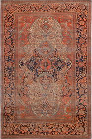
Antique Tabriz Haj Jallili Garden and Animal Design Persian Rug 13 ft 2 in x 9 ft 8 in (4.01 m xNazmiyal Auctions4.4(34)See Sold PriceFeb 25, 2024
Antique Persian Serapi Rug 13 ft 4 in x 10 ft 11 in (4.06 m x 3.32 m)Nazmiyal Auctions4.4(34)See Sold PriceFeb 25, 2024
No Reserve Antique Caucasian Kuba Runner Rug 14 ft 8 in x 3 ft 4 in (4.47 m x 1.01 m)Nazmiyal Auctions4.4(34)See Sold PriceFeb 25, 2024
No Reserve Antique Persian Mohtashem Kashan Rug 6 ft 7 in x 4 ft 4 in (2 m x 1.32 m)Nazmiyal Auctions4.4(34)See Sold PriceFeb 25, 2024
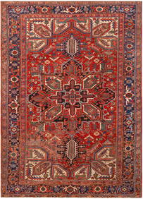
No Reserve Antique Persian Heriz Rug 11 ft 8 in x 8 ft 6 in (3.55 m x 2.59 m)Nazmiyal Auctions4.4(34)See Sold PriceFeb 25, 2024
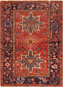
No Reserve Antique Persian Karajeh Rug 4 ft 3 in x 3 ft 1 in (1.29 m x 0.93 m)Nazmiyal Auctions4.4(34)See Sold PriceFeb 25, 2024
No Reserve Antique Caucasian Kazak Rug 7 ft 9 in x 4 ft 2 in (2.36 m x 1.27 m)Nazmiyal Auctions4.4(34)See Sold PriceFeb 25, 2024
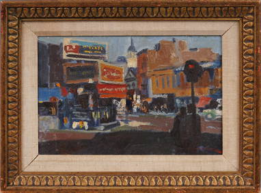
Antique American Greenwich Village New York City Spring Street Soho Modernist Street Scene PaintingCurated Gallery Auctions4.6(107)See Sold PriceFeb 25, 2024
ANDREW RAYMOND JANSON OIL ON BOARD ADIRONDACKSCharleston Estate Services Ltd.4.5(54)See Sold PriceMar 03, 2024
Johann Homann Hand-Colored Map Engraving, c. 1730Auctions at Showplace4.5(723)See Sold PriceMar 17, 2024
Willem Blaeu, Etc. 17th C. Antiquarian Maps, 2Auctions at Showplace4.5(723)See Sold PriceMar 17, 2024
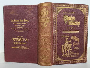
1887 PHILLIP'S ELITE DIRECTORY SHOPPING GUIDE FOR NEW YORK CITY antiqueJasper524.5(9.7k)See Sold PriceFeb 27, 2024
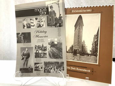
2 Macys 1985 Star Photo Book & 1980 NYC CalendarThe Benefit Shop Foundation Inc.4.3(2.9k)See Sold PriceMar 13, 2024
Georg Bockler Map of Ancient Jerulsaem EtchingAuctions at Showplace4.5(723)See Sold PriceApr 07, 2024
1887 ANTIQUE NEW YORK CITY SHOPPING GUIDE - PHILLIPS' ELITE DIRECTORYNY Elizabeth 4.3(83)See Sold PriceMar 03, 2024
Black and white map of part of New York City (mostly Manhattan)Proverde Auctions4.3(3)See Sold PriceFeb 28, 2024
Laminated Unique Media New York City MapRapid Estate Liquidators and Auction Gallery4.5(1.1k)See Sold PriceFeb 29, 2024