SoldAmerica.- Burr (David H.) - An Atlas of the State ofContaining a Map of the State and of the Several Counties, [third edition], engraved title, 51 hand-coloured engraved maps and plans on 52 sheets as issued, including double-page and folding, some foxSee Sold Price
SoldBURR, DAVID H. An Atlas of the State of New YoBURR, DAVID H. An Atlas of the State of New York. Beautiful engraved title with hand-colored vignette view of the Hudson near Fishkill, 52 hand-colored maps, including 2-sheet map of Manahttan (numberSee Sold Price
Sold(NEW YORK.) Burr, David H. An Atlas of the Sta(NEW YORK.) Burr, David H. An Atlas of the State of New York. Engraved title, 51 (of 52) hand-colored engraved maps, lacks the map of Tioga. Folio, 555x435 mm, contemporary 1/2 calf, worn, needs rebinSee Sold Price
SoldDavid H. Burr, An Atlas of the State of New York…BURR, David H (1803 - 1875). An Atlas of the State of New York, Containing a Map of the State and Several Counties. Projected and Drawn by a Uniform Scale from documents deposited in the Public OfficeSee Sold Price
SoldBURR. Atlas of New York. 1829BURR, David H. (1803-1875) An Atlas of the State of New York. Text by Simeon De Witt. New York: David H. Burr, 1829. Large folio (23x18 inches, 584x457 mm). Illustrated title with an engraSee Sold Price
SoldBURR, DAVID H. A New Universal Atlas ComprisinBURR, DAVID H. A New Universal Atlas Comprising Separate Maps of all the Principal Empires, Kingdoms & States throughout the World. Engraved title, 63 hand-colored engraved maps. Folio, 400x325 mm, moSee Sold Price
SoldDavid H. BurrDavid H. Burr, "Map of the Counties of New York, Queens, Kings, and Richmond" from An Atlas of the State of New York..., 1829, hand-colored engraving, 13 3/4 in. x 18 1/2 in., framed. Provenance: EstaSee Sold Price
Burr's important Universal Atlas 1835Heading: Author: Burr, David H. Title: A New Universal Atlas; Comprising Separate Maps of all the principal Empires, Kingdoms & States Throughout the World: and forming a distinct Atlas of the UnitedSee Sold Price
Map of the United StatesReserve Reduced! Title/Content of Map: Map of the United States Date: 1855 Cartographer: BURR, DAVID H. Publisher: U.S. SENATE Size: 31.25 x 49 inches exhibiting the several collection districts. SenaSee Sold Price
SoldMAP - United States. BurrUnited States. David H. Burr, Map of the United States Exhibiting the Several Collection Districts, 1854 (circa). Hand Color. This huge map was issued just after the Gadsden Purchase and prior to theSee Sold Price
SoldMap of the United StatesTitle: Map of the United States Publication Date: 1855 Publisher: U.S. SENATE Size: 31.25 x 49 "exhibiting the several collection districts. Senate Ex.Doc. No.77. Drawn by David H. Burr..." Burr was dSee Sold Price
Burr, United States, 1835Very Early Colton Map 77. [MAP]. BURR, David H. United States. By David H. Burr. [at bottom] Published by J. H. Colton & Co. New York 1835 Engraved and Printed by S. Stiles & Co. N. York [beloSee Sold Price
SoldBurr, David H., A UNIVERSAL ATLAS(New York: William Hall & Co., 1836), a title page and index precede 63 hand-colored maps with tissue overlays, folio (15.25 x 13 in.) embossed covers with gilt title on front, leather spine. This aSee Sold Price
SoldBurr's folding map of U.S. 1833Heading: Author: Burr, David H. Title: United States Place Published: New York Publisher:J.H. Colton & Co. Date Published: 1833 Description: Copper-engraved map, hand-colorSee Sold Price
Burr's folding map of U.S. 1833Heading: Author: Burr, David H. Title: United States Place Published: New York Publisher:J.H. Colton & Co. Date Published: 1833 Description: Copper-engraved map, hand-colorSee Sold Price
SoldBURR, DAVID H. Map of the State of New-York wiBURR, DAVID H. Map of the State of New-York with Parts of the adjacent Country. Large hand-colored engraved case map in 24 sections, 1185x1445 mm overall; linen-backed; with the publisher's roan case,See Sold Price
SoldBURR, DAVID H. A New Universal Atlas.BURR, DAVID H. A New Universal Atlas. Engraved title, 63 hand-colored engraved plates. Small folio, original cloth, needs rebinding; quite a bit of soiling early on in margins, scattered foxing (heaviSee Sold Price
SoldBURR, DAVID H. Map of the State of New York anBURR, DAVID H. Map of the State of New York and the Surrounding Country. Engraved 6-sheet wall map joined, 1355x1510 mm overall; hand-colored in wide outline; very small area of dampstaining in a smalSee Sold Price
DAVID H. BURR - STATE OF NEW YORK, 1840David H. Burr - State Of New York, 1840 - 36 X 31 In. - Giclée Print - Gallery Stretched - Ready to hang.See Sold Price
DAVID H. BURR - STATE OF NEW YORK, 1840David H. Burr - State Of New York, 1840 - 36 X 31 In. - Giclée Print - Gallery Stretched - Ready to hang.See Sold Price
DAVID H. BURR - STATE OF NEW YORK, 1840David H. Burr - State Of New York, 1840 - 36 X 31 In. - This Giclée Print Is Gallery Stretched And Ready To Hang Or Lean Against A Wall, Or Display On An Easel. - A Giclée Print Is The Highest QualiSee Sold Price
DAVID H. BURR - STATE OF NEW YORK, 1840DAVID H. BURR - STATE OF NEW YORK, 1840 - Giclée on Canvas - Size-36 x 31 in.See Sold Price
DAVID H. BURR - STATE OF NEW YORK, 1840David H. Burr - State Of New York, 1840 - 36 X 31 In. - This Giclée Print Is Gallery Stretched And Ready To Hang Or Lean Against A Wall, Or Display On An Easel. - A Giclée Print Is The Highest QualiSee Sold Price
DAVID H. BURR - STATE OF NEW YORK, 1840DAVID H. BURR - STATE OF NEW YORK, 1840 - 36 x 31 in. - Museum Wrapped The Piece Of Art Is Ready To Hang Or Lean Against A Wall, Or Display On An Easel. - A Giclée Print Is The Highest Quality PrintSee Sold Price
Leo Heinrich c1837 Register of German Italian States Tan Calf Scarce!Luis Porretta Fine Arts4.3(10)See Sold PriceMar 02, 2024
1849 Mitchell School ATLAS 24 MAPS America Holy Land France Africa Egypt AsiaSchilb Antiquarian Rare Books4.8(421)See Sold PriceMar 31, 2024
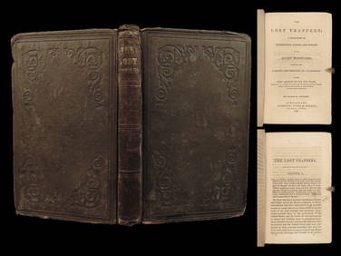
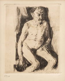
1859 Lost Trappers Rocky Mountains California Fur Trade Western Frontier ExploreSchilb Antiquarian Rare Books4.8(421)See Sold PriceMar 31, 2024
Royal Doulton Bunnykins Colorway, Ohio State Touchdown DB96Lion and Unicorn4.7(1.8k)See Sold PriceFeb 25, 2024
AMERICAN MIXED MEDIA ARTWORK PAINTING BY TOM BURRAntique Arena Inc.4.5(852)See Sold PriceFeb 24, 2024
Arrowsmith & Lewis - Map of the United StatesTrillium Antique Prints & Rare Books4.5(30)See Sold PriceFeb 24, 2024
Carey, pub. 1796 - A Chart of the West IndiesTrillium Antique Prints & Rare Books4.5(30)See Sold PriceFeb 24, 2024
Carey, pub. 1796 - Map of the State of MarylandTrillium Antique Prints & Rare Books4.5(30)See Sold PriceFeb 24, 2024
Carey, pub. 1796 - Map of GeorgiaTrillium Antique Prints & Rare Books4.5(30)See Sold PriceFeb 24, 2024
Carey, pub. 1796 - Map of The State of South CarolinaTrillium Antique Prints & Rare Books4.5(30)See Sold PriceFeb 24, 2024
Carey, pub. 1796 - Map of KentuckyTrillium Antique Prints & Rare Books4.5(30)See Sold PriceFeb 24, 2024
Carey, pub. 1796 - Map of the Tennassee State formerly part of North Carolina (Tennessee)Trillium Antique Prints & Rare Books4.5(30)See Sold PriceFeb 24, 2024
Blackie (Pub) 1882 Folio Map. West USA - Pacific StatesAlbion Auctions4.6(336)See Sold PriceMar 01, 2024
Blackie (Pub) 1882 Folio Map. United States of North AmericaAlbion Auctions4.6(336)See Sold PriceMar 01, 2024
Robert H Labberton - Map of The Territory of the Present United States - The territory of theProverde Auctions4.3(3)See Sold PriceFeb 28, 2024
Map of United States of North America, 1785Antiques Online Auctions4.6(407)See Sold PriceMar 14, 2024
Signed and Numbered Print The Blue Belt by David WrightRapid Estate Liquidators and Auction Gallery4.5(1.1k)See Sold PriceMar 03, 2024
Attributed to John Sloan (American, 1871-1951) Conte Crayon And Graphite on Paper, 1924, "Accident (DuMouchelles4.6(825)See Sold PriceMar 15, 2024
Käthe Kollwitz (German, 1867-1945) Etching on Paper 1891, "Sitzender Männlicher Akt", H 6"DuMouchelles4.6(825)See Sold PriceMar 15, 2024