SoldAlexander Hogg Maps of North & South Wales & 2 otAlexander Hogg pair of coloured engravings, Maps of North & South Wales, 7.5 x 12 ins. a map of Belgii Universi and a print of Buckingham Palace.See Sold Price
SoldCary (John) Map of North& South WalesCary (John) A Map of North Wales; A Map of South Wales,2 engraved maps with outline hand-colouring, 395 x 520mm., and 405 x 475mm., respectively, vertical folds, some light offsetting, upper mSee Sold Price
Sold2 vol., engraved frontispiece, additional vignettRoscoe (Thomas) Wanderings and Excursions in North [...South] Wales, 2 vol., engraved frontispiece, additional vignette titles, 2 folding maps, outlined in colour and c.97 views, occasional foSee Sold Price
SoldRoscoe (Thomas) South [...North] WalesRoscoe (Thomas) Wanderings and Excursions in South [...North] Wales, together 2 vol., additional engraved vignette titles, plates and maps, some foxing, uniformly bound in contemporary half caSee Sold Price
SoldHarrison (John) - [General and County Atlas],disbound map sheets comprising double-hemisphere world, 5 continents, England & Wales, Ireland, Scotland, 2 maps on 1 sheet of North and South Wales, and 37 English county maps, 47 engraved map sheetsSee Sold Price
Sold4 MAPS WALPOLE'S NEW & COMPLETE BRITISH TRAVELERNorth Wales, Yorkshire, Hampshire, Glocestershire, Middlesex, Dorsetshire, Surrey, and Sussex. Publisher Alexander Hogg at the King's Arms #16 Paternoster Row. 16.5" x 26.5" $40 - $80See Sold Price
4 MAPS WALPOLE'S NEW & COMPLETE BRITISH TRAVELERNorth Wales, Yorkshire, Hampshire, Glocestershire, Middlesex, Dorsetshire, Surrey, and Sussex. Publisher Alexander Hogg at the King's Arms #16 Paternoster Row. 16.5" x 26.5" $40 - $80See Sold Price
Map of North Wales glazed and framedMORDEN Map of South Wales coloured framed and glazed and New and Correct Map of North Wales coloured, framed and glazed. 43cm x 36cm. 2 itemsSee Sold Price
18TH CENTURY COPPERPLATE ENGRAVING OF THE WESTERN18TH CENTURY COPPERPLATE ENGRAVING OF THE WESTERN HEMISPHERE Engraved map of the Atlantic Ocean and North and South America, 11 1/2" x 10", executed by British engraver THOMAS BOWEN (d. 1790). The mapSee Sold Price
SoldGrp: 9 Maps of South AmericaGroup of nine maps of South America. Includes Alexander Hogg (1778-1824), "The North Side of the largest of Queen Charloue's Islands as it appeared running along shore to the Westward" London, ca. 179See Sold Price
EARLY MAPS OF THE AMERICAS (2)Good pair of early nineteenth-century maps depicting the Americas, includes: hand-outlined lithograph map, 11' x 12 1/2', a depiction of the Western Hemisphere, including North and South America, NewSee Sold Price
SoldEvans (J.) A Tour Through Part of North (South) WaEvans (J.) A Tour Through Part of North (South) Wales,2 vol., second edition of the first part, contemporary sprinkled calf, the John Rutherfurd of Edgerston copy, with booklabels, 1802-04 (6)See Sold Price
Hall: Antique Map of North & South Wales, 1856TITLE/CONTENT OF MAP: 'North & South Wales' DATE PRINTED: 1856 IMAGE SIZE: Approx 61.5 x 43.0cm, 24.25 x 17 inches (Large); Please note that this is a folding map. TYPE: Antique atlas map with originaSee Sold Price
2 Antique Maps2 Antique maps- 1.) ''A Modern Map of South Wales'' 2). ''Westmoreland''. Both maps have been trimmed, hand-coloring. 8 x 10'' ea.See Sold Price
SoldGross, Alexander 1920 Large Maps. North & South PolePair of Large Lithograph Maps Published 1920, London for "The Daily Telegraph Victory Atlas of the World" by Alexander Gross. Centre fold as published. Paper Size: 25 x 19.5 inch (64 x 49cm) Good CondSee Sold Price
Gross, Alexander 1920 Large Maps. North & South PolePair of Large Lithograph Maps Published 1920, London for "The Daily Telegraph Victory Atlas of the World" by Alexander Gross. Centre fold as published. Paper Size: 25 x 19.5 inch (64 x 49cm) Good CondSee Sold Price
A. and C. Black Map [Wales]A. and C. Black, Edinburgh, map of North and South Wales, circa mid-19th century. Measures 23-in. x 16.25-in. image size, 24.5-in. x 17.375-in. sheet size. In VG/VG+ condition with minor foxing, brownSee Sold Price
(2) MAPS, NORTH & SOUTH AMERICA, J. WYLD, HEWITT(lot of 2) Framed maps of America, comprising: (1) North and South America, drawn by James Wyld (English, 1812-1887), engraved by Hewitt, Sc. 1 Buckingham Place, Fitzroy Square, plate 36, bottom leftSee Sold Price
Sold'A SURVEY OF PORTRAITS IN WELSH HOUSES'. By John'A SURVEY OF PORTRAITS IN WELSH HOUSES'. By John Steegman. Vols. 1-2. North & South Wales. Published 1962.See Sold Price
Late 17th century Robert Morden Maps of WalesLate 17th century Robert Morden Maps of Wales circa 1695, hand colored copperplate engravings, A NEW AN CORRECT MAP OF NORTH WALES and SOUTH WALES. Presented in matching wooden frames. DOA 21 x 24 in.See Sold Price
SoldRowe (Robert) Rowe's Maps of the English CountiesRowe (Robert) Rowe's Maps of the English Counties,40 map sheets only, including maps of England, North Wales and South Wales, engraved maps in original hand-colouring, each c.435 x 360mm., orSee Sold Price
SoldGeorge and Philip & Sons.- AustraliaGeorge and Philip & Sons, Publishers.- Australia, with New South Wales, 2 engraved maps with outline hand-colouring, each c.520 x 620mm., each with central vertical fold, the former with minorSee Sold Price
Sold[MAPS] Military Survey of Australia: Wallerawang & Bathurst2 Military Survey of Australia Maps 1. Wallerawang, New South Wales (1935)2. Bathurst, New South Wales (1936) Very Good Condition.See Sold Price
SoldRobert Morden,A map of North Wales, another of South Wales by Morden together with a hand coloured plan of Brighton (3)See Sold Price
Crams Colored Railway Map and Shippers Guide of South Dakota 1908-1909JM Hobby Supply and Railroad Artifact Auctions4.4(126)See Sold PriceFeb 24, 2024
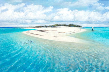
Al Barnes (1937-2015), A Meeting at the PointCopley Fine Art Auctions4.5(40)See Sold PriceFeb 24, 2024
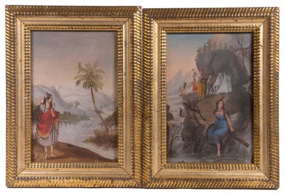
PR OF NAIVE 19TH C AMERICAN ALLEGORICAL MINIATURE PAINTINGSThomaston Place Auction Galleries4.4(389)See Sold PriceFeb 24, 2024
LARGE LATE 17TH C. DUTCH CHART OF CANADA, GREAT LAKES, NEW FRANCE, LABRADOR, HUDSON BAY, BY PIERREThomaston Place Auction Galleries4.4(389)See Sold PriceFeb 24, 2024
LARGE EARLY 18TH C. DUTCH CHART OF UPPER NORTH AMERICA, PIERRE MORTIER (1661-1711), FRAMEDThomaston Place Auction Galleries4.4(389)See Sold PriceFeb 24, 2024
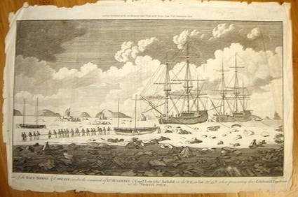
ALEXANDER HOGG ca1790 Engraving Captain Mulgrave Ships Ice Bound Cpt CookLuis Porretta Fine Arts4.3(10)See Sold PriceMar 02, 2024
Westland Oil Company North Dakota Road MapCheck the Oil Promotions, LLC4.6(305)See Sold PriceFeb 25, 2024
Portfolio of 15 County Maps by Robert Morden (English 1650-1703)Nadeau's Auction Gallery4.7(405)See Sold PriceFeb 24, 2024
[ENSLAVEMENT & ABOLITION]. Letter from a southern slave trader describing the transportation ofFreeman's | Hindman4.4(1.6k)See Sold PriceFeb 27, 2024
Carey, pub. 1796 - Map of the Tennassee State formerly part of North Carolina (Tennessee)Trillium Antique Prints & Rare Books4.5(30)See Sold PriceFeb 24, 2024
Map: An 18thC engraved and hand coloured map of North America and South America, titled DeClaydon Auctioneers Ltd4.3(125)See Sold PriceFeb 26, 2024
1822 MAP of NORTH & SOUTH AMERICA GEOGRAPHICAL STATISTICAL HISTORICAL antiqueJasper524.5(9.8k)See Sold PriceFeb 27, 2024
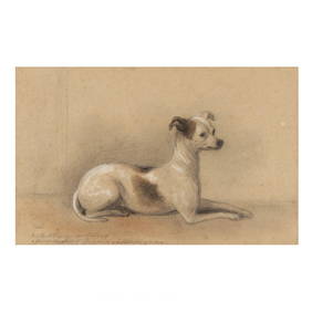
Alexander Blaikley (English, 1816-1903), Study of an Italian GreyhoundLeland Little4.5(697)See Sold PriceFeb 29, 2024
Map of United States of North America, 1785Antiques Online Auctions4.6(410)See Sold PriceMar 14, 2024
Herman Moll A New Map of Ye North Parts of AmericaWillow Auction House4.5(284)See Sold PriceMar 14, 2024


![Harrison (John) - [General and County Atlas], (1 of 1)](https://p1.liveauctioneers.com/410/101520/51901365_1_x.jpg?height=282&quality=70&version=1490021964)


![A. and C. Black Map [Wales] (1 of 2)](https://p1.liveauctioneers.com/5755/162895/82236696_1_x.jpg?height=282&quality=70&version=1582932540)


![[MAPS] Military Survey of Australia: Wallerawang & Bathurst (1 of 3)](https://p1.liveauctioneers.com/8597/296734/157735920_1_x.jpg?height=282&quality=70&version=1690170365)


![[ENSLAVEMENT & ABOLITION]. Letter from a southern slave trader describing the transportation of (1 of 3)](https://p1.liveauctioneers.com/197/319238/171468031_1_x.jpg?height=282&quality=70&version=1707520367)