SoldAfter Delisle and Buache, 1785 Wold MapAfter Guillaume Delisle (French, 1675-1726) and Philippe Buache (French, 1700-1773), "Mappemonde à Pufage du Roi", hand-colored double-hemisphere world map, 1785, with elaborate banner cartouche andSee Sold Price
After Guillaume Delisle and Philippe BuacheAfter Guillaume Delisle (French, 1675-1726) and Philippe Buache (French, 1700-1773), "Mappemonde à Pufage du Roi", hand-colored double-hemisphere world map, 1785, with elaborate banner cartouche andSee Sold Price
SoldDel’Isle & Buache map of northern discoveries, 1780Heading: Author: De l'Isle, Joseph Nicholas & Philippe Buache Title: Carte des Nouvelles Découvertes au Nord de la Mer du Sud, Tant à 'Est de la Siberie et du Kamtchatka, ou à l'Ouest de la NouvelSee Sold Price
1730 Delisle/Buache Map of The Caspian Region1730 Delisle/Buache Map of The Caucasus and Caspian Region -- Carte des Pays Voisins de la Mer Caspiene Dressee pour l'Usage du Roy sur la Carte de cete Mer Faite par l'Ordre du Czar, sur les MemoireSee Sold Price
SoldDelisle/Buache Map of Caucasus & Caspian Region 1730Map: 1730 Delisle/Buache Map of The Caucasus and Caspian Region -- Carte des Pays Voisins de la Mer Caspiene Dressee pour l'Usage du Roy sur la Carte de cete Mer Faite par l'Ordre du Czar, sur les MemSee Sold Price
Sold[MAPS] Group of Maps by Homann, Delisle, and Buache.[MAPS] Group of Maps by Homann, Delisle, and Buache. 18th century. Including Tabula Geographica Campaniae (Homann), copper-engraved map of the Champagne region of France, hand-coloring, pictorial cartSee Sold Price
SoldGuillaume Delisle and Philippe Buache 18th Cent.Guillaume Delisle and Philippe Buache 18th Cent. ''Carte D'Amerique'' Map Engraving 29''x36.5'' Framed. Impressive French hand tinted map of America dated 1722. Visibly in excellent condition with strSee Sold Price
SoldAntique Map, Guillaume Delisle and Philippe Buache,Guillaume (de L'Isle) Delisle (French, 1675-1726) and Philippe Buache (French, 1700-1773), "Mappemonde a l'ufage de l'instr; Premiers Geographes et de l'Academie des Sciences Reyue et Augmentee des DeSee Sold Price
SoldMAP, Italy, DelisleItaly. Delisle/Buache, L'Italie Dressee sur les Observations de Mrs. de l'Academie Royale des Sciences..., 1745 (dated). Hand Color. A fine large map showing all of Italy, including Sicily, Sardinia aSee Sold Price
MAP, Western Hemisphere, DelisleWestern Hemisphere - America. Delisle/Buache, Carte d'Amerique, Dressee pour l'Usage du Roy, 1745 (dated). Hand Color. Guillaume Delisle's map of the Americas, first published in 1722, was one of theSee Sold Price
SoldCarte des Nouvelles Decouvertes au Nord de la Mer du...Carte des Nouvelles Decouvertes au Nord de la Mer du Sud... Joseph Nicolas Delisle (1688-1768) and Philippe Buache (1700-1773). engraved map with original hand-color in outline. Paris: Desaint and SaiSee Sold Price
SoldGuillaume Delisle / Philippe Buache / Jean-Claude"Carte d'Europe, Dress‚e Pour L'Usage Du Roi (Map of Europe Created For the Use of the King)" Antique map on paper under glass Unsigned Sight size: 20.75" H x 25.25" W Provenance: Private CollectionSee Sold Price
[MAP]. DELISLE (after). Carte du Mexique.... 1783279. [MAP]. DELISLE, Guillaume [Insulanus] & Philippe Buache (after). DEZAUCHE [Jean Claude]. Carte du Mexique et des Etats Unis D’Amérique, Partie Méridionale. DresséeSee Sold Price
SoldAntique Hand-Colored World Hemispheres Map entitleAntique Hand-Colored World Hemispheres Map entitled Mappemonde a L'ufage du Roi, Par Guillaume Delisle et Philipe Buache and measures 18 1/2 inches by 26 inches (sight) and is mounted under glass in aSee Sold Price
SoldDezauche map of Americas 1800Title: Carte d'Amérique, Dressée pour Instruction, Par Guil. Delisle et Phil. Buache, Premiers Geographes de l'Academie des Sciences. Nouvellement Revue, Augmentée et Assujetie aux Nles. ObservatioSee Sold Price
Dezauche map of Americas 1800Title: Carte d'Amérique, Dressée pour Instruction, Par Guil. Delisle et Phil. Buache, Premiers Geographes de l'Academie des Sciences. Nouvellement Revue, Augmentée et Assujetie aux Nles. ObservatioSee Sold Price
Dezauche map of Americas 1800Title: Carte d'Amérique, Dressée pour Instruction, Par Guil. Delisle et Phil. Buache, Premiers Geographes de l'Academie des Sciences. Nouvellement Revue, Augmentée et Assujetie aux Nles. ObservatioSee Sold Price
MAP - Western Hemisphere. DelisleWestern Hemisphere - America. Delisle/Dezauche, Carte d'Amerique, Dressee pour l'Instruction, par Guil. Delisle et Phil. Buache..., 1790 (dated). Hand Color. This is a later, updated edition of one ofSee Sold Price
Sold(Maps and Charts, Northern Hemisphere), Delisle, J(Maps and Charts, Northern Hemisphere), Delisle, Joseph Nicolas (1688-1768), Carte des nouvelles decouvertes au nord de la Mer du Sud, Paris: G. Delisle and P. Buache, 1750 or later, hand-colored in wSee Sold Price
Sold1761-1836. Maps of Dublin 1836, and British Isles1761-1836. Maps of Dublin 1836, and British Isles 1761 Royaume de la Grande Bretagne ou des Isles Britanniques (22 x 18cm on large sheet) by Guillame Delisle and Phil Buache, also 1836, Dublin, -drawnSee Sold Price
Sold*LIEBAUX, JEAN BAPTISTE(Mid 18th C. French) "Tabula Italia Antique", unframed and unmounted 2-piece engraved map for Guillermo Delisle, printed by Phillippe Buache, artist name and dated 1745 upper right plate, approximateSee Sold Price
MAP, North Pole, DelisleNorth Pole. Delisle/Dezauche, Hemisphere Septentrional pour voir Plus Distinctement les Terres Arctiques, 1790 (circa). Hand Color. This is a Buache/Dezauche issue of this important map, originally prSee Sold Price
SoldMAP, Western Hemisphere, DelisleWestern Hemisphere - America. Delisle/Dezauche, Carte d'Amerique, Dressee pour l'Usage du Roi..., from Atlas Geographique des Quartes Parties du Monde, 1785 (dated). Hand Color. This is a later, updatSee Sold Price
SoldPhillipe Buache, ''Mappemonde,'' 1745[World]. Phillipe Buache after De L'Isle. Mappemonde A L'Usage du Roy Par Guillaume Delisle Premier Georgraphe De SM. [1745]. Double-page engraved map, two hemispheres, based on Guillaume de L'Isle'sSee Sold Price
COVENS & MORTIER 1745 MAP OF THE GLOBEThomaston Place Auction Galleries4.4(386)See Sold PriceFeb 24, 2024
HENRY ALKEN The Quorn Hunt Original Aquatint ca1840 Equestrian FramedLuis Porretta Fine Arts4.3(10)See Sold PriceMar 02, 2024
[MAP]. [ALBRIZZI, Giambatista, 1698-1777]. Carta Geografica...Potter & Potter Auctions4.6(539)See Sold PriceMar 07, 2024
D'Oyly (Calcutta, India) - Procession of the CurruckpoojaTrillium Antique Prints & Rare Books4.5(30)See Sold PriceFeb 24, 2024
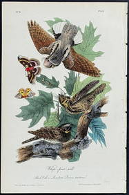
Audubon - Common Osprey Fish Hawk. 15Trillium Antique Prints & Rare Books4.5(30)See Sold PriceFeb 24, 2024
1845 Delisle/Bauche Map of Martinique -- Carte de l'Isle de la Martinique Colonie Francoise de l'uneJasper524.5(9.8k)See Sold PriceFeb 27, 2024
La Nubia ed Abissinia. Red Sea Ethiopia Sudan Eritrea Arabia. ZATTA 1785 mapJasper524.5(9.8k)See Sold PriceFeb 28, 2024
Buffon, Vaugody & Bell 1785 America - Map of the New ContinentAlbion Auctions4.6(336)See Sold PriceMar 01, 2024
Buffon, Vaugody & Bell 1785 Map of the Old Continent. Africa, AsiaAlbion Auctions4.6(336)See Sold PriceMar 01, 2024
Antique Map - Views on the coast of Asia. J. Webber del. Engraved after J. Webber and W. Bligh.Proverde Auctions4.3(3)See Sold PriceFeb 28, 2024
James Cook - Map of the Friendly Isles - Tonga IslandsProverde Auctions4.3(3)See Sold PriceFeb 28, 2024
Map of United States of North America, 1785Antiques Online Auctions4.6(407)See Sold PriceMar 14, 2024
Antique Map of France, 1703 by Gillaume Del Isle PrintAntiques Online Auctions4.6(407)See Sold PriceMar 14, 2024
John Senex Map of Louisiana & Mississippi RiverWillow Auction House4.5(283)See Sold PriceMar 14, 2024


![[MAPS] Group of Maps by Homann, Delisle, and Buache. (1 of 8)](https://p1.liveauctioneers.com/928/178407/89893862_1_x.jpg?height=282&quality=70&version=1599515639)


![[MAP]. DELISLE (after). Carte du Mexique.... 1783 (1 of 8)](https://p1.liveauctioneers.com/514/38480/16487162_1_x.jpg?height=282&quality=70&version=1363614971)


![[MAP]. [ALBRIZZI, Giambatista, 1698-1777]. Carta Geografica... (1 of 1)](https://p1.liveauctioneers.com/928/318880/171361280_1_x.jpg?height=282&quality=70&version=1707501302)