MAP - PIETER SCHENK / VALK / JANSSEN Hand Colored superb Map Central Italy c1702Luis Porretta Fine Arts4.3(10)See Sold PriceMar 02, 2024
CHARLES ROLLIN c1828 Ceasar Hand Colored Africa Military MapLuis Porretta Fine Arts4.3(10)See Sold PriceMar 02, 2024
MAP - Dufour, A. H. ( Malte / Brun ) :MAP - ESPAGNE PARTIE SUD DIVISEE EN PROVINCES ANCIENNES ( MAPLuis Porretta Fine Arts4.3(10)See Sold PriceMar 02, 2024
RIGOBERT BONNE c1787 Original Colored Map Germany & Region 15" x 12"Luis Porretta Fine Arts4.3(10)See Sold PriceMar 02, 2024
AMBROISE TARDIEU c1822 Napoleonic War Map GermanyLuis Porretta Fine Arts4.3(10)See Sold PriceMar 02, 2024
MAP - AMBROISE TARDIEU c1822 Napoleonic Miltary Map GermanyLuis Porretta Fine Arts4.3(10)See Sold PriceMar 02, 2024
1822 Rare Map by Ambroise Tardieu Napoleon Caldiero Battle of Vento 17" x 11Luis Porretta Fine Arts4.3(10)See Sold PriceMar 02, 2024
PIETER SCHENK / VALK / JANSSEN Hand Colored Map of Rhodes Greece ca1702 vgcLuis Porretta Fine Arts4.3(10)See Sold PriceMar 02, 2024
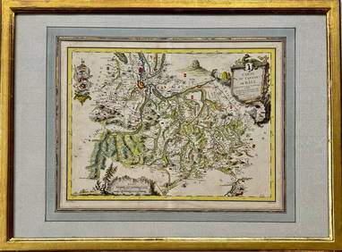
Map: Carte du Canton de Bale, Jacques Clermont, Paris, 1788Kensington Estate Auction4.6(219)See Sold PriceFeb 26, 2024
A Seminal map of Canada, which first appeared in 1703Carte du Canada ou de la Nouvelle France... Guillaume Del'Isle. Engraved map. Paris: Chez L'Auteur, 1703. 20 1/4 x 26 1/4 inches visible, 30 1/2 x 36 3/4 inches framed. One of the seminal maps of CanaSee Sold Price
De L'Isle Map of Canada 1703 First StateDE L'ISLE, Guillaume (1675-1726).Carte du Canada ou de la Nouvelle France...Engraved map with original hand color in outline.Paris: Guillaume De L'Isle, Rue de Cannettes, 1703 [First Issue].19 1/4" xSee Sold Price
SoldDeLisle Map of New Canada, 1703 1st EditionDE L'ISLE, Guillaume (1675-1726). Carte du Canada ou de la Nouvelle France... Engraved map with original hand color in outline. Paris: Guillaume De L'Isle, Rue de Cannettes, 1703 [First Issue]. 20 3/8See Sold Price
Sold1745 Guillaume De L'Isle Carte Du Canada ou de la1745 Guillaume De L'Isle Carte Du Canada ou de la Nouvelle France first published in 1703- 2 sheet map of French Canada, 20.5” x 26.25”See Sold Price
SoldDe L'Isle Carte du CanadaDe L'ISLE, Guillaume (1675-1726). Carte du Canada ou de la Nouvelle France. Engraved map with original hand color in part. Paris: De L'isle, Rue des Canettes, 1703. (First Issue). 20 1/4" x 26 1/4" viSee Sold Price
De L'Isle Carte du CanadaDe L'isle, Guillaume (1675-1726). Carte du Canada ou de la Nouvelle France. Engraved map with original hand color in part. Paris: De L'isle, Rue des Canettes, 1703. (First Issue). 20 1/4" x 26 1/4" viSee Sold Price
SoldCa.1732 A Map of the British-Plantations AmericaA MAP OF THE BRITTISH PLANTATIONS ON THE CONTINENT OF AMERICA. Ca.1732 written in pencil on verso. This map first appeared in Volume 28 of Thomas Salmon's Modern History, published in 1736. Salmon's hSee Sold Price
SoldA New Map of Georgia, with Part ofCarolina, Florida and Louisiana by Eman. Bowen, 1748 Bowen (1694-1767), important early map of colonial Georgia, Cumming #267, this map first appeared in John Harris' Navigantium in the 1744-48 editioSee Sold Price
SoldA New Map of Georgia, with Part ofCarolina, Florida and Louisiana by Eman. Bowen, 1748 Bowen (1694-1767), important early map of colonial Georgia, Cumming #267, hand-colored, this map first appeared in John Harris' Navigantium in theSee Sold Price
SoldMap of "Florida Called By Ye French Louisiana"Engraved Map of "Florida Called By Ye French Louisiana" by Herman Moll, London, 1728/1732, 8" x 10-3/4". Unframed. This map first appeared in 1728 and was re-issued in 1732 with some updated informatiSee Sold Price
Sold9 European Maps, Fricx, 18th CenturyAfter Eugene Henri Fricx (France, 1644-1730), nine (9) engraved European maps, published c. 1745, from Covens and Mortier's "ATLAS DES PAYS BAS...." Some of the maps first appeared in Eugene Fricx's TSee Sold Price
SoldDe l'Isle's seminal map of Canada 1730 issueTitle: Carte du Canada ou de la Nouvelle France et des Decouvertes qui ont été faites Dressée sur plusiers Observations et sur un grand nombre de Relations imprimées ou manuscrites Author: De l'IsSee Sold Price
Laet, Johannes de. Nova Francia et Regiones AdiacentesLaet, Johannes de Nova Francia et Regiones Adiacentes C. 1630 Copperplate engraving; uncoloured Printed area: 35.6 x 28 cm; 14 x 11 in One of the foundation maps of Canada, first printed map to includSee Sold Price
SoldJacob van Meurs. Africae Accurata Tabula. [AmsteJacob van Meurs. Africae Accurata Tabula. [Amsterdam]: Jacob vSee Sold Price
Jode, Gerard de. Germaniae Totius...Jode, Gerard de Germaniae Totius, Nostrae Europae Celeberrimae Regionis, Descriptio Singularis 1593 Copperplate engraving; coloured Printed area: 52.5 x 38.3 cm; 20.6 x 15 in This map appeared first iSee Sold Price
SoldWhite Map of the Carolinas / VirginiaWhite, John (1540-1593). Americae Pars, Nunc Virginia Dicta. Engraved map. Frankfurt, 1590. 12 3/4" x 17 1/2" sheet, 18 1/2" x 24 1/4" framed. A seminal map of America: the first detailed depiction ofSee Sold Price
Sold[MAP REFERENCE]. 4 volumes sold together[Cartography]. Kershaw, Kenneth. EARLY PRINTED MAPS OF CANADA. I. 1540-1703. Ancaster: K. A. Kershaw, 1993. 1/2 Morocco, edition limited to 30 numbered copies. ** Kershaw, Kenneth. EARLYPRINTED MAPS OSee Sold Price
SoldOrtelius Map of the Holy LandTerra Sancta. Abraham Ortelius (1527-1598). Engraving with original hand color. Antwerp: 1584 (1608). 18 x 22 3/4 inches sheet.This map of the Holy Land first appeared in Orteliu's third AdditamentumSee Sold Price
SoldSanson Map of New FranceSanson d'Abbeville, Nicholas (1600-1667). Le Canada, ou Nouvelle France. Engraved map with original hand color. Paris: Pierre Mariette, 1656. 16" x 21 1/2" sheet, 19" x 25" framed. The First Map of CaSee Sold Price
SoldA MAP, "CARTE DE LA LOUISIANE ET COURS DU MISSISSIPPI,A MAP, "CARTE DE LA LOUISIANE ET COURS DU MISSISSIPPI," BY GUILLAUME DELISLE, PARIS, 1718. 21" x 29 1/2". Framed. NOTE: The very rare first issue of this seminal map of the region, depicted before theSee Sold Price
First state of an important map of the Trans-Mississippi WestMathew Carey's map, Missouri Territory formerly Louisiana, is one of the seminal maps of the period and the first atlas map to provide the cartographic detail derived from the return of the Lewis & ClSee Sold Price
SoldCanada.- Gray (Hugh) Letters from Canada, firstCanada.- Gray (Hugh) Letters from Canada, first edition, folding engraved map with border hand-coloured, slightly offset, 3 folding tables, contemporary calf, gilt, minor rubbing and scuffs, [Sabin 28See Sold Price
SoldWILLIAM KURELEK MAP OF CANADAWilliam Kurelek (1927-1977) First edition 1975 "Map of Canada" lithograph. Pencil signed and numbered 535/554. 33" x 32" w/ frame.See Sold Price
SoldWILLIAM KURELEK, RCA, OSA (1927 - 1977)Map of Canada framed Pagurian Press coloured lithograph, first edition, signed in pencil and numbered 163 of 554 23.5 x 24.5 in (59.7 x 62.2 cm) (f = 32 x 32 x 2 in)See Sold Price
Delaware Lackawanna and Western RR Phoebe Snow PlateJM Hobby Supply and Railroad Artifact Auctions4.4(127)See Sold PriceFeb 24, 2024
Missouri Pacific RR State Flowers PlateJM Hobby Supply and Railroad Artifact Auctions4.4(127)See Sold PriceFeb 24, 2024
LARGE LATE 17TH C. DUTCH CHART OF CANADA, GREAT LAKES, NEW FRANCE, LABRADOR, HUDSON BAY, BY PIERREThomaston Place Auction Galleries4.4(393)See Sold PriceFeb 24, 2024
Map UNITED COUNTIES LEEDS & GRENVILLE by Walling 1861 Rare Canada Map 5ft x 5ftLuis Porretta Fine Arts4.3(10)See Sold PriceMar 02, 2024
Parker Vacumatic Slender Maxima Fountain Pen SetNorth American Pen Auctions LTD4.4(12)See Sold PriceFeb 24, 2024
Parker Vacumatic Major Burgundy Fountain PenNorth American Pen Auctions LTD4.4(12)See Sold PriceFeb 24, 2024
Waterman Night & Day Sterling Silver Fountain Pen, BoxedNorth American Pen Auctions LTD4.4(12)See Sold PriceFeb 24, 2024
Waterman Night & Day Gold Filled Fountain Pen, BoxedNorth American Pen Auctions LTD4.4(12)See Sold PriceFeb 24, 2024
1787 George Washington American Florida Shakespeare Tobacco Gentlemans MagazineSchilb Antiquarian Rare Books4.8(428)See Sold PriceMar 31, 2024
[MAP]. [ALBRIZZI, Giambatista, 1698-1777]. Carta Geografica...Potter & Potter Auctions4.6(545)See Sold PriceMar 07, 2024
Putnam - First Map of the State of Ohio by Rufus PutnamTrillium Antique Prints & Rare Books4.5(32)See Sold PriceFeb 24, 2024
The Disney Fair Special Edition Ticket & Luggage TagRapid Estate Liquidators and Auction Gallery4.5(1.1k)See Sold PriceFeb 25, 2024
MICHAEL SNOW: COVER TO COVER. 1st ED. NSCAD, 1975Toronto Book Auctions4.3(13)See Sold PriceMar 07, 2024
Robert de Vaugondy - Map of Canada - Mer de l' Ouest or Sea of the West and a Northwest PassageProverde Auctions4.3(3)See Sold PriceFeb 28, 2024
The Disney Fair Special Edition Ticket & Luggage TagRapid Estate Liquidators and Auction Gallery4.5(1.1k)See Sold PriceMar 03, 2024


![[MAP REFERENCE]. 4 volumes sold together (1 of 1)](https://p1.liveauctioneers.com/1124/187577/94368838_1_x.jpg?height=282&quality=70&version=1607095126)


![[MAP]. [ALBRIZZI, Giambatista, 1698-1777]. Carta Geografica... (1 of 1)](https://p1.liveauctioneers.com/928/318880/171361280_1_x.jpg?height=282&quality=70&version=1707501302)