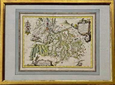
Map: Carte du Canton de Bale, Jacques Clermont, Paris, 1788Kensington Estate Auction4.6(219)See Sold PriceFeb 26, 2024
SoldA RENAISSANCE MAP, "Ptolemy Map of the World (DieA RENAISSANCE MAP, "Ptolemy Map of the World (Die Weltkarte des Ptolemäus)," ULM AND ARMSHEIM, 1482, hand colored woodblock print on paper, "Insculptum est per Johanne Schnitzer de Armsheim," paSee Sold Price
SoldCLAUDIUS PTOLEMY Map of World Offset LithographCLAUDIUS PTOLEMY Map of World Offset Lithograph, inscription to lower left reads Map of World by Claudius Ptolemy c 150 AD Ulm Edition 1482, Reproduced from the original in the Edward E Ayer CollectioSee Sold Price
PTOLEMY'S WORLD MAP. Compared with actual positions. Kiepert. Britannica 1898TITLE/CONTENT OF MAP: 'Map ptolemy's map of the World, compared with the actual positions after H. Kiepert' DATE PRINTED: 1898 IMAGE SIZE: Approx 24.5 x 38.0cm, 9.5 x 14.75 inches (Large); Please noteSee Sold Price
SoldWorld Atlas RAND Mc NALLYWorld Atlas RAND Mc NALLY 1937. It has copy Ptolemy's Map of the World originally executed in Second Century engraved at ULM in 1482. Book measurement approximate: 14 x 11 In. Shipping cost: $15.00 exSee Sold Price
SoldPTOLEMAEUS - PTOLEMY. World map. 1478 or 1490WORLD MAP- PTOLEMAEUS [Untitled world map][Rome: 1478 or 1490]. Double-page engraved map of the ancient world, on two sheets joined, (392 x 555 mm), verso of centre with pasted paper backstriSee Sold Price
SoldAfter S. Munster, Typus OrbisSebastian Munster, German, 1488-1552. Woodcut map of Ptolemy's map of the Ancient World, with border of clouds and wind-heads. Not examined out of the frame. Slight rippling, discoloration, and indicaSee Sold Price
SoldAncient World Maps, Mela Posidonius & Ptolemy 1683 MapAncient World. Maps by Mela, Posidonius & Ptolemy. Mallet 1683 Old Antique. Title of the Map: 'globe De Mella; Globe De Posidonius; Globe De Ptolomee' date Printed: 1683 image Size: Approx Overall PagSee Sold Price
SoldPtolemy / Waldseemuller World MapGenerale Ptholemei...(World). Claudius Ptolemaues & Martin Waldseemuller. Woodcut Map. Strasbourg: J. Schott, 1513 or 1520. 17 1/2 x 22 3/4 inches sheet, 29 x 34 inches framed. The Strasbourg PtolemySee Sold Price
SoldTOLOMEO, Claudio (100-168). [Untitled World mapTOLOMEO, Claudio (100-168). [Untitled World map according to Ptolemy of Alexandria.] Vienna: Melchior & Gaspar Treschel, [s.n. 1541]. Bellissima mappa del mondo colorata a mano in epoca leggermente suSee Sold Price
ANCIENT WORLD. Maps by Mela, Posidonius & Ptolemy. MALLET 1683 old antiqueTITLE OF THE MAP: 'Globe de Mella; Globe de Posidonius; Globe de Ptolomee' (Du Globe Terrestre) DATE PRINTED: 1683 IMAGE SIZE: Approx Overall page size 13 x 21cm approximately (5 x 8 inches); image siSee Sold Price
Ptolemy Map of Pakistan*** START PRICE IS THE RESERVE *** [Asia] After PTOLEMAEUS, Claudius (after 83 - ca 168 AD). Nona Asiae Tabula. Woodcut map. Strassburg: Johann Schott 1513. 17 1/2" x 23 3/4" sheet. Comparable: Old WoSee Sold Price
ANCIENT WORLD. Maps by Mela, Posidonius & Ptolemy.TITLE OF THE MAP: 'Globe de Mella; Globe de Posidonius; Globe de Ptolomee' (Du Globe Terrestre) The top image on the right hand side shows the entire map. To view a close up of the map showing the levSee Sold Price
ANCIENT WORLD. Maps by Mela, Posidonius & Ptolemy.TITLE OF THE MAP: 'Globe de Mella; Globe de Posidonius; Globe de Ptolomee' Date: 1683 IMAGE SIZE: Approx Overall page size 13 x 21cm approximately (5 x 8 inches); image size 10.5 x 14.5cm approximatelSee Sold Price
ANCIENT WORLD. Maps by Mela, Posidonius & Ptolemy.TITLE OF THE MAP: 'Globe de Mella; Globe de Posidonius; Globe de Ptolomee' Date: 1683 IMAGE SIZE: Approx Overall page size 13 x 21cm approximately (5 x 8 inches); image size 10.5 x 14.5cm approximatelSee Sold Price
ANCIENT WORLD. Maps by Mela, Posidonius & Ptolemy. MALLET 1683 old antiqueTITLE OF THE MAP: 'Globe de Mella; Globe de Posidonius; Globe de Ptolomee' (Du Globe Terrestre) DATE PRINTED: 1683 IMAGE SIZE: Approx Overall page size 13 x 21cm approximately (5 x 8 inches); image siSee Sold Price
SoldMannert DOUBLE HEMISPHERE WORLD MAP 1839 NuremburgDetails: MANNERT, Conrad von (1756-1834). [Double Hemisphere World Map] Die Erde in Zwey Halbkugeln. Nuremberg: Christoph Fembo, 1839. Copper-engraved map, with original outline colour. Good conditioSee Sold Price
SoldMunster World Map 1540MUNSTER, Sebastian (1489-1552). La Table des Isles Neufues, Lesquelles on Appelle Isles d'Occident & d'Indie pour Diuers Regardz. Engraved map from Ptolemy's Geographica. Basel:1540 (French Text, StatSee Sold Price
SoldBunting World MapBUNTING, Heinrich (1545-1606). [World Map] Die eigentliche und warhafftige gestalt der Erden und des Meers. Woodblock engraving. Magdeburg, 1581 from Cosmographia Universalis. 11 3/4" x 13 3/4" sheet.See Sold Price
Bunting Cloverleaf World MapBunting, Heinrich (1545 – 1606). Cloverleaf World Map (Die Gantze Welt in ein Kleberblat Welches in der etadt hannover....) Woodcut. Magdeburg, 1581 or later. 11 1/4 x 15 1/2" sheet. First publishedSee Sold Price
SoldAncient world based on Ptolemy.Reserve Reduced! Title/Content of Map: Ancient world based on Ptolemy. Date: 1598/99 Size: 9x11” Additional Info: by Ruscelli, Venice. Reserve: $500.00 Jasper52 negotiates the lowest reserves so bidSee Sold Price
Ancient world based on Ptolemy.Reserve Reduced! Title/Content of Map: Ancient world based on Ptolemy. Date: 1598/99 Size: 11x9” Ruscelli, Venice Reserve: $575.00 Jasper52 negotiates the lowest reserves so bidders always get the bSee Sold Price
ANCIENT WORLD. World according to Ptolemy AD150. Sketch map. BARTHOLOMEW 1901TITLE/CONTENT OF MAP: 'The World according to Ptolemy A.D. 150' DATE PRINTED: 1901 IMAGE SIZE: Approx 12.5 x 20.0cm, 4.75 x 8 inches (Medium) TYPE: Antique map CONDITION: Good; suitable for framing. PSee Sold Price
MAP, Persia - Iran, PtolemyPersia - Iran. Ptolemy/Magini, Tabula Asiae V, from Geografia cioe Descrittione Universale della Terra, 1598 (published). Black & White. This Ptolemaic map, presented on a trapezoidal projection, showSee Sold Price
WORLD AS KNOWN TO ANCIENTS Herodotus Hanno Ptolemy Pliny SDUK 1844 old mapTITLE/CONTENT OF MAP: 'THE WORLD AS KNOWN TO THE ANCIENTS' DATE PRINTED: This map was originally published by Chapman & Hall in 1842; this date is printed on the map. This edition of the map was printSee Sold Price
Vintage Full Color World Map LithographThe Benefit Shop Foundation Inc.4.3(2.9k)See Sold PriceFeb 28, 2024
Nova Totius Full Color Geographical World MapThe Benefit Shop Foundation Inc.4.3(2.9k)See Sold PriceFeb 28, 2024
Louis Vuitton Damier Graphite Renaissance Map Danube Slim PMBidhaus4.3(762)See Sold PriceFeb 24, 2024
1730 BIBLE in DUTCH ILLUSTRATED w/ MAPS antique MASSIVE FOLIO BIBLIAJasper524.5(9.9k)See Sold PriceFeb 27, 2024
3 Vintage The World Lithographs, By JanssonThe Benefit Shop Foundation Inc.4.3(2.9k)See Sold PriceMar 13, 2024
Louis Vuitton Keepall Bandouliere Bag Limited Edition Renaissance Map Damier Graphite 50Pacific Global Auction3.9(280)See Sold PriceFeb 24, 2024
Blackie (Pub) 1882 Folio Map. World on Mercators ProjectionAlbion Auctions4.6(341)See Sold PriceMar 01, 2024
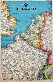
Vintage Map - Krigskarta - War Map - Second World War, published 1940Proverde Auctions4.3(3)See Sold PriceFeb 28, 2024
Framed Vintage Style Visscher Commander Repro MapRapid Estate Liquidators and Auction Gallery4.5(1.1k)See Sold PriceMar 01, 2024
Laminated Unique Media The World Map 1996 EditionRapid Estate Liquidators and Auction Gallery4.5(1.1k)See Sold PriceMar 02, 2024