SoldA New Map of our Country,c 1854.[United States]. A New Map Of Our Country, Prospective. And Present Compiled from Government Surveys and other Reliable Sources. Wall map. NY: Gaston & Johnson, 1854. 50 x 57 3/4 inches, excluding elaSee Sold Price
SoldFindlay Classical Atlas Color MapsFindlay, Alexander. A Classical Atlas to Illustrate Ancient Geography, comprised in twenty-five maps… New York, Harper Brothers, no date (c.1854), Hardcover, later 3/4 leather. 25 hand-colored maps.See Sold Price
SoldA New Map of the Country Twenty Miles Round (sic)A New Map of the Country Twenty Miles Round (sic) London, Printed for Carington Bowles in St. Paul's Church Yard, London [n.d., c. 1780], copperplate engraving with hand-coloured delineations, laid onSee Sold Price
Bowen: Antique Map of Gulf of St. Lawerence, 1752Title: A New & Accurate Map of the Islands of Newfoundland, Cape Briton, St. John and Anticosta; Together with the Neighbouring Countries of Nova Scotia, Canada &c...1752 Bowen Gulf of St. Lawerence wSee Sold Price
SoldPair Antique 19th Century Atlases, Bound MapsPair Antique 19th Century Atlases. ‘Mitchell’s New General Atlas Containing Maps of Various Countries of the World, Plans of Cities, Etc.’ published by S. Augustus Mitchell, Jr. c 1860. ‘AtlasSee Sold Price
SoldPair Antique 19th Century Atlases, Bound MapsPair Antique 19th Century Atlases. ‘Mitchell’s New General Atlas Containing Maps of Various Countries of the World, Plans of Cities, Etc.’ published by S. Augustus Mitchell, Jr. c 1860. ‘AtlasSee Sold Price
Sold18th century Bowen map of Carolinas,[A New & Accurate Map of the Provinces of North & South Carolina, Georgia, & C.,] Emanuel Bowen (1720-1767), "Country of the Cherokees" shown extending to Louisiana, 16 x 18-1/2 in.; modern wood frameSee Sold Price
SoldFRAMED 1860 COUNTY MAP OF TEXASFramed copy of "County Map of Texas with inset of Galveston Bay & Vicinity", c. 1860, believed to be from "Mitchell's New General Atlas, containing Maps of the Various Countries of the World, Plans ofSee Sold Price
Williams map of U.S. with inset of West 1854Heading: (United States) Author: Williams, W. Title: A New Map of the United States upon which are Delineated the Vast Works of Internal Communications, Routes across the Continent &c. Showing also CaSee Sold Price
SoldTwo Framed 19th Century Hand-colored Maps of New YoTwo Framed 19th Century Hand-colored Maps of New York City, 1836, J. Disturnell, and 1846, G.W. and C.B. Colton Map of the Country Thirty Miles Round the City of New York, respective sight size 22 x 2See Sold Price
Sold18th c. Hand-colored map18th c. Hand-colored map- A New Map of Turkey- in Europe, divided into all its provinces, with the adjacent countries in Europe and Asia, drawn chiefly from the maps published by the Imperial AcademySee Sold Price
SoldA New and Accurate Map of Negrolandand the Adjacent Countries by Eman. Bowen, circa 1750 Bowen (c. 1694-1767), an interesting map of West Africa, with some hand-coloring, with a large decorative cartouche, compass rose, notes on slave-See Sold Price
SoldMap Of New York City19th c. map "A PLAN of the CITY and ENVIRONS of NEW YORK" / "Copied From an Original Drawing by David Grim in the possesion of The N.Y. Historical Society for D. T. Valentines Manual 1854". Sight 23 1See Sold Price
Sold18th Century Map of the SoutheastLondon, 1747, [A New & Accurate Map of the Provinces of North & South Carolina, Georgia, & C.,] by Emanuel Bowen (1720-1767), noting towns, forts and Indian populations, "Country of the Charokees [sicSee Sold Price
SoldKansas and Nebraska-Edward E. Hale-1854With an original map from the latest authorities., an early and rare anti-slavery argument in the new terrirtories. Boston. Phillips, Sampson & Co. New York J. C. Derby 1854. Cover off, spine off, nSee Sold Price
SoldColton & Co., Map of the Country thirty three milesMap of the Country thirty three miles around the City of New York. New York: G.W. and C.B. Colton & Co., 1853. Sheet size: 24 7/8 x 23 3/4 inches.See Sold Price
SoldMap of the Country Thirty Three Miles Around the CityG.W. & C.B. Colton & Co. lithograph. New York: G.W. & C.B. Colton & Co., 1869. 24 7/8 x 23 3/4 inches, 34 1/4 x 34 1/8 inches framed. An unusual circular representation of New York City and its enviroSee Sold Price
Soldc.1780 Map of New York and ConnecticutMapsc.1780 Map of New York and Connecticut c.1780, “Map of Hudson’s River, With The Adjacent Country”, Choice Very Fine. This well preserved, 12.5” x 9.25” map, printed iSee Sold Price
Sold18th C. Map of LouisianaAn 18th C. hand-colored engraved map by Emanuel Bowen, titled "A New and Accurate Map of Louisiana with Part of Florida and Canada, and the Adjacent Countries", Plate 59. Likely from the "Complete AtlSee Sold Price
SoldA NEW UNIVERSAL ATLAS... Phila: 1854.[Atlas]. A NEW UNIVERSAL ATLAS Containing Maps of the various Empires, Kingdoms, States and Republics of the World With a special Map of each of the United States, plans of the Cities, &c. ComprehendeSee Sold Price
SoldMap, Hudson River, Rev. War, Sauthier, 1776At the top of the map is written: "A Topographical Map of Hudsons River, with the Channels Depth of Water, Rocks, Shoals, &c. and the Country Adjacent, from Sandy-Hook, New York and Bay to Fort EdwardSee Sold Price
SoldScarce 1st St. Revolutionary War English Map Of USClaude Joseph Sauthier (French, 1736-1802), "A Topographical Map of Hudsons River, with the Channels Depth of Water, Rocks, Shoals, &c. and the Country Adjacent, from Sandy-Hook, New York and Bay to FSee Sold Price
SoldThe Tanner/Mitchell Universal Atlas 1854Title: A New Universal Atlas Containing Maps of the various Empires, Kingdoms, States and Republics of the World with a special Map of each of the United States, plans of Cities &c. Comprehended in seSee Sold Price
Sold2 Lithograph Maps2 lithograph maps - 18 3/4" x 22" Homanno's Low Countries, Jakarta, Inset Views of New York, c. 1710 and 14 3/4" x 19 1/2" image size Blaeu's 1640 Map of the Paderborn Espiscopate, w/text on verso.See Sold Price
LATE 17TH C. FRENCH MAP OF THE NEW WORLD BY ALEXIS-HUBERT JAILLOT (1632-1712)Thomaston Place Auction Galleries4.4(393)See Sold PriceFeb 24, 2024
WESLEY REV. JOHN Sermons On Several Occasions c1854 Full Tree Calf Vol. IILuis Porretta Fine Arts4.3(10)See Sold PriceMar 02, 2024
George Hayward - Map of the City of New York 1854Dane Fine Art Auctions4.4(498)See Sold PriceMar 07, 2024
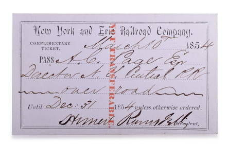
1854 New York and Erie Railroad Company Annual PassRail & Road Auctions4.6(165)See Sold PriceMar 08, 2024
HAMMOND'S READY REFERENCE HISTORICAL ATLAS 1920North American Artifact Auctions4.7(198)See Sold PriceApr 20, 2024
[SHEET MUSIC]. [UNCLE TOM’S CABIN]. HOWARD, George C. (1818...Potter & Potter Auctions4.6(545)See Sold PriceMar 07, 2024
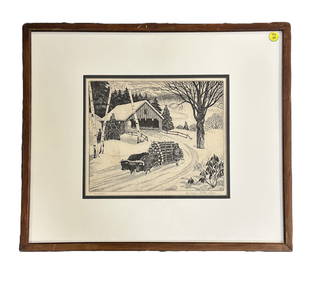
WILLIAM MACLEAN (1897-1978) THE OX TEAM ETCHINGCharleston Estate Services Ltd.4.5(69)See Sold PriceMar 03, 2024
Johann Homann Hand-Colored Map Engraving, c. 1730Auctions at Showplace4.6(740)See Sold PriceMar 17, 2024
Willem Blaeu, Etc. 17th C. Antiquarian Maps, 2Auctions at Showplace4.6(740)See Sold PriceMar 17, 2024
D'Entrecasteaux - Map of Australia (New Holland), New Zealand, and southern Asia and surroundingTrillium Antique Prints & Rare Books4.5(32)See Sold PriceFeb 24, 2024
Mitchell - Map of the City of Washington (Washington, DC)Trillium Antique Prints & Rare Books4.5(32)See Sold PriceFeb 24, 2024
Map: A 19thC engraved and hand coloured map of Buckingham titled A New Map of BuckinghamshireClaydon Auctioneers Ltd4.3(125)See Sold PriceFeb 26, 2024
1764 MAP OF COUNTRIES THIRTY MILES ROUND LONDON antique 12.5 by 15"Jasper524.5(9.9k)See Sold PriceFeb 27, 2024
1738 RUSSIA SIBERIA & GREAT TARTARY Description illustrated ANTIQUE in ENGLISHJasper524.5(9.9k)See Sold PriceFeb 27, 2024
1750 Bowen Map of Bermuda and St. Kitts -- A New & Accurate Map of Bermudas or Sommer's Islands...Jasper524.5(9.9k)See Sold PriceFeb 27, 2024
Perry, Matthew C. 1856 Large Map. Shah Bay, Lew Chew I. JapanAlbion Auctions4.7(341)See Sold PriceMar 01, 2024
Jules Verne, L'Archipel en Feu, Au Steamer Red MacaronLion and Unicorn4.8(1.9k)See Sold PriceMar 10, 2024


![[SHEET MUSIC]. [UNCLE TOM’S CABIN]. HOWARD, George C. (1818... (1 of 1)](https://p1.liveauctioneers.com/928/318880/171361191_1_x.jpg?height=282&quality=70&version=1707501302)