SoldA NEW MAP OF NORTH AMERICA by Herman MOLLHistoric MapsCalifornia as an Island! "A NEW MAP OF NORTH AMERICA ACCORDING TO THE NEWEST OBSERVATIONS," By Herman Moll, Geographer, Choice Very Fine. Hand-colored in outline, this detailed maSee Sold Price
SoldEarly French Colonies North America HERMAN MOLL C1732Details: MOLL, Herman (1654-1732). A New Map of ye North Parts of America claimed by France under ye Names of Louisiana, Mississipi, Canada & New France, with the Adjoyning Territories of England & SSee Sold Price
Sold5 pieces. Hand-Colored Engraved Maps - North Amer5 pieces. Hand-Colored Engraved Maps - North America: Moll, Herman. New England, New York, New Jersey and Pennsylvania & C." [London], [ca. 1740]. 7 x 10 1/2 inches; 200 x 270 mm. Old color. Framed. *See Sold Price
SoldHERMAN MOLL COLONIAL-ERA MAP OF NORTH AMERICAMap: "A New Map of the North Parts of America claimed by France, under ye names of Louisiana, Mississipi [sic Mississippi], Canada, and New France with ye adjoining territories of England and Spain,"See Sold Price
SoldMoll Engraved Map of AmericaA new map of the north parts of America claimed by France under ye names of Louisiana, Mississipi, Canada, and New France with ye adjoining territories of England and Spain. Herman Moll (1654-1732). ESee Sold Price
SoldEarly Map of North AmericaHerman Moll British (1654-1732)A NEW MAP OF THE NORTH PARTS OF AMERICA CLAIMED BY FRANCE UNDRE YE NAMES OF LOUISIANA, MISSISSIPPI, CANADA, AND NEW FRANCE WITH YE ADJOYNING TERRITORIES OF ENGLAND AND SSee Sold Price
SoldMOLL. A New Map of the North Parts of America claMAP - MOLL, Herman. A New Map of the North Parts of America claimed by France.London: printed for H. Moll, 1720. Engraved map (sheet size: 648x1045 mm.), hand-colored in outline, with small oSee Sold Price
SoldMoll, Herman, @New Map of the North Parts of AmMoll, Herman, "A New Map of the North Parts of America claimed by France under ye names of Louisiana, Mississippi, Canada and New France with ye Adjoyning Territories of England and Spain" , London, 1See Sold Price
SoldMOLL, HERMAN. A New Map of the North Parts ofMOLL, HERMAN. A New Map of the North Parts of America claimed by France. Two-sheet engraved map, 620x1030 mm sheet size, trimmed close just outside neatline; hand-colored in outline; a bit toned overaSee Sold Price
SoldMoll's large North America Calif. an islandTitle: A New Map of the North Parts of America claimed by France under ye names of Louisiana, Mississipi, Canada and New France with ye Adjoyning Territories of England and Spain Author: Moll, HermanSee Sold Price
Sold18th century map, North America,Mexico, "A Map of Mexico or New Spain Florida now called Louisiana and Part of California & c." by Herman Moll, from [Atlas Geographus: or; A Compleat System of Geography, (Ancient and Modern) For AmeSee Sold Price
SoldHerman Moll, (Dutch, 1654-1732), An engraved mapHerman Moll (Dutch, 1654-1732) An engraved map of Mexico or New Spain, Florida now called Louisiana and part of California, together with an engraved map of North America. 7 1/2 x 10 1/4 inches.See Sold Price
SoldHERMAN MOLL (ENGLISH, C. 1654 TO 1732) MAP OF EASTERNHERMAN MOLL (ENGLISH, C. 1654 TO 1732) MAP OF EASTERN NORTH AMERICA, hand-colored, on laid paper, title in rectangular cartouche to top center "A New and Exact MAP of the DOMINIONS / of the KING of GRSee Sold Price
SoldMoll (Herman) Map of South Sea CompanyMoll (Herman) A New & Exact Map of the Coast, Countries and Islands within ye limits of ye South Sea Company,extending from southern North America to Terra del Fuego, 3 plans of ports above, aSee Sold Price
SoldMoll Beaver Map, 1715MOLL, Herman (1654-1732). [Beaver Map] A New and Exact Map of the Dominions of the King of Great Britain on ye Continent of North America... Engraved Map with original hand color in part. Sold By H. MSee Sold Price
Moll Map of American ColoniesMOLL, Herman (c.1654-1732). A New and Exact Map of the Dominions of the King of Great Britain on ye Continent of North America...Engraved Map with original hand color in part. Sold By H. Moll over agaSee Sold Price
SoldMoll NEW AND EXACT MAP OF THE DOMINIONS OF THE KING OFDetails: MOLL, Herman (fl. 1678-1732). A New and Exact Map of the Dominions of the King of Great Britain on ye continent of North America containing Newfoundland, New Scotland, New England, New York,See Sold Price
Sold1 piece. Hand-Colored Engraved Map. Moll, Herman.1 piece. Hand-Colored Engraved Map. Moll, Herman. A New and Exact Map of the Dominions of the King of Great Britain on Ye Continent of North America..." (London), 1715 [but 1755]. 24 x 40 inches; 610See Sold Price
SoldMOLL, HERMAN. A New and Exact Map of the DominTHE BEAVER MAP. MOLL, HERMAN. A New and Exact Map of the Dominions of the King of Great Britian on ye Continent of North America. Engraved folding 2-sheet map joined, 1030x620 mm, margins wide on sidSee Sold Price
SoldMOLL, HERMAN. A Map of New France Containing Canada,MOLL, HERMAN. A Map of New France Containing Canada, Louisiana &c. in Nth America. Hand-colored engraved map of colonial North America. 7¾x10¾ inches sheet size, ample margins; mounted to foSee Sold Price
SoldMOLL, Herman (d. 1732). A New and Exact Map of thMOLL, Herman (d. 1732). A New and Exact Map of the Dominions of the King of Great Britain on ye continent of North America. [London:] 1715. Engraved map hand-colored in outline, on two sheetsSee Sold Price
SoldMOLL, HERMAN. A New and Exact Map of the DominTHE FAMOUS BEAVER MAP. MOLL, HERMAN. A New and Exact Map of the Dominions of the King of Great Britain on ye Continent of North America. Engraved 2-sheet map joined, 1000x610 mm, margins trimmed to pSee Sold Price
Moll Beaver MapMoll, Herman (c.1654-1732). [Beaver Map] A New and Exact Map of the Dominions of the King of Great Britain on ye Continent of North America... Engraved Map with original hand color in part. Sold By H.See Sold Price
SoldMoll (Herman) - Virginia and Maryland,the Chesapeake Bay area, engraved map with original hand-colouring in outline, 275 x 210mm., 1729; with A Map of the British and French Plantations in North America, covering New England, Nova Scotia,See Sold Price
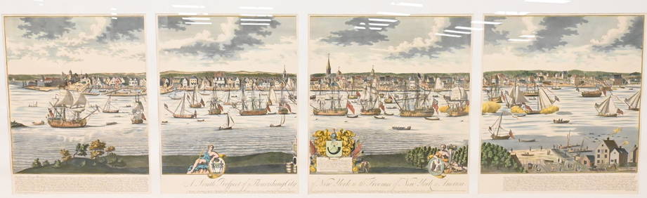
A South Prospect of Ye Flourishing City of New York in the Province of New York, North AmericaNadeau's Auction Gallery4.7(401)See Sold PriceFeb 24, 2024
Arrowsmith & Lewis - Map of PolynesiaTrillium Antique Prints & Rare Books4.5(30)See Sold PriceFeb 24, 2024
Arrowsmith & Lewis - Map of North AmericaTrillium Antique Prints & Rare Books4.5(30)See Sold PriceFeb 24, 2024
Arrowsmith & Lewis - Map of the World on Mercator's ProjectionTrillium Antique Prints & Rare Books4.5(30)See Sold PriceFeb 24, 2024
Arrowsmith & Lewis - Map of LouisianaTrillium Antique Prints & Rare Books4.5(30)See Sold PriceFeb 24, 2024
Arrowsmith & Lewis - Map of the United StatesTrillium Antique Prints & Rare Books4.5(30)See Sold PriceFeb 24, 2024
Audubon - 8 Quadruped LithographsTrillium Antique Prints & Rare Books4.5(30)See Sold PriceFeb 24, 2024
Map: An 18thC engraved and hand coloured map of North America and South America, titled DeClaydon Auctioneers Ltd4.3(125)See Sold PriceFeb 26, 2024
New and Correct Map of North America With the West India Islands,Jasper524.5(9.8k)See Sold PriceFeb 27, 2024
Herman Moll A New Map of Ye North Parts of AmericaWillow Auction House4.5(283)See Sold PriceMar 14, 2024