SoldA New Map of Metropolitan Railways... Lon: 1872.[Britain] A New Map Of Metropolitan Railways, Tramways & Miscellaneous Improvements Deposited At The Private Bill Office Nov. 30, 1871, For Session 1872. Front cover title: "Proposed London ImprovemenSee Sold Price
Sold2 Folding maps: Staffordshire.[Britain/Staffordshire]. 2 Folding Maps. ++ Bacon’s New Survey map of Staffordshire and Shropshire. Showing Railways, Roads, Elevations, & Distances… Lon: G. W. Bacon & Co., (nd), (small label atSee Sold Price
Sold[MAPS] Sands & McDougall Map of Melbourne and SuburbsSands & McDougall New Revised Map of Melbourne and Suburbs: Extended Map of All Metropolitan Roads, Streets, Railways, Tramways and Postal Districts Melbourne: Sands & McDougall, No date [1960s].113.5See Sold Price
SoldStanford (E) Map of Metropolitain RailwaysStanford (Edward) Publisher.- A New Map of Metropolitain Railways & Miscellaneous Improvements Deposited at the Private Bill Office, Nov. 30, 1863, for session 1864,a standard metropolitan mapSee Sold Price
Cruchley (George Frederick) - Cruchley's New Plan offrom Pentonville to Kennington and from Bethnal Green to Hyde Park, showing the metropolitan and mainline railway system including Liverpool Street Station, lithographed map with hand-colouring, 480 xSee Sold Price
GWR/London Overground railway Shepherds Bush UxbridgeTITLE/CONTENT OF MAP: 'Great Western Railway (New railways) railways (Nos 3 & 4). County of London. Metropolitan Borough of Hammersmith. Sheet No 24. Ealing and Shepherds Bush. Session 1905' DATE: 190See Sold Price
SoldA Group of UK Railway and Tourist MapsUK Railway and Tourist Maps for Metropolitan Railways dated 1866, Railway Map of England and Wales dated 1841, Sheffield's Railway Map for 1846 and a quantity of other Railway Maps for Wembley Park, HSee Sold Price
SoldCruchley's New Railway Map of LondonCruchley (George Frederick) Cruchley's New Railway Map of London & its Environs,large map of London, from Highgate to Streatham, and Hammersmith to East India Dock, defining existing railwSee Sold Price
SoldPhillips (George) Phillips' New Library Map of LonPhillips (George) Phillips' New Library Map of London and Its Environs,showing from Muswell Hill down to Streatham, and Acton across to Abbey Wood, lithographed map, with some hand-colouring,See Sold Price
SoldJigsaw. Wallis (Edward) - Wallis's New Railway Map ofincludes the proposed extension of the Great Western line from Exeter to Penzance, engraved map with original hand-colouring, mounted on wood and dissected, 635 x 495mm., slight surface wear, mminor dSee Sold Price
SoldRAILWAYS: "Map of New South Wales Railways showingRAILWAYS: "Map of New South Wales Railways showing coach and other routes from the various stations : together with Mileage from Sydney With Diagrams of North Coast, South Coast, and Parts of SouthernSee Sold Price
SoldAntique Map : New York - 1872Antique Map : New York - 1872. Hand-Tinted. Size : 22.5" x 15.5"See Sold Price
Antique Map : New York - 1872Antique Map : New York - 1872. Hand-Tinted. Size : 22.5" x 15.5"See Sold Price
Antique Map : New York - 1872Antique Map : New York - 1872. Hand-Tinted. Size : 22.5" x 15.5"See Sold Price
SoldLouis Mons Metropolitan Railway locomotive 'New CLouis Mons oil on wooden panel Metropolitan Railway locomotive 'New Cross' initialled 9 x 11in.See Sold Price
Early 1900's Railway Service Map, New York, New JerseyDated 1906, hand-colored Railway Service map, covering The New England & Middle Atlantic States. Engraver: Fisk, E. F. Cartographer: International Correspondence Schools Copyright holder: InternationaSee Sold Price
Early 1900's Railway Service Map, New York, New JerseyDated 1906, hand-colored Railway Service map, covering The New England & Middle Atlantic States. Engraver: Fisk, E. F. Cartographer: International Correspondence Schools Copyright holder: InternationaSee Sold Price
Sold5 Maps [Ca. 1646] - 1804: England, northern Europ[Britain/Europe]. 5 maps. ++ A New Map Of The Netherlands. Lon: John Cary, 1804. 18 x 20 1/4 (sheet 20 1/8 x 20 3/4). ++ A New Map Of Bohemia And Moravia. Cary, 1801. 20 1/4 x 23 1/2 (sheet 23 1/4 x 2See Sold Price
Rand McNally/2600 Feet to an Inch/Metropolitan Map /ofTitle: Rand McNally/2600 Feet to an Inch/Metropolitan Map /of New York City Publication Date: c1910 Cartographer: RAND McNALLY & COMPANY Publisher: RAND McNALLY & COMPANY Description: LARGE WALL MAP WSee Sold Price
SPECTACULAR EARLY 1900s NEW YORK CITY WALL MAPMetropolitan Map of New York City. Lithographed map. Rand McNally and Co., c 1910. 66" x 46" sheet. LARGE WALL MAP WITH ORIGINAL RODS SHOWING ALL MANHATTAN, BROOKLYN, JAMAICA BAY, ADJOINING NEW JERSEYSee Sold Price
SoldWall Map of France Post-RevolutionA New Map of France divided into Metropolitan Circles and Departments agreeable to the decree of the National Assembly in 1790. John Fairburn (fl. 1789 - 1840). Engraving with original hand color in oSee Sold Price
SoldCA.1888 LITHOGRAPH STREET RAILWAY, N.Y.C.A CIRCA-1888 LITHOGRAPH OF THE METROPOLITAN STREET RAILWAY, NEW YORK CITY, NY, depicting the 23rd St. & 4th Ave. stop with cross town cars, fine building details, horse-drawn formal carriages and otheSee Sold Price
Rand, McNally & Co.Title: Rand, McNally & Co.'s New Business Atlas Map of Chicago. Railway Terminal Map of Chicago. Publication Date: 1900 Cartographer: RAND, MCNALLY & CO. Publisher: RAND, MCNALLY & CO. Size: 26HeightSee Sold Price
Crawfordsville and Southwestern RY First Mortgage Bond Prospectus Book-1872JM Hobby Supply and Railroad Artifact Auctions4.4(127)See Sold PriceFeb 24, 2024
1892 Adams and Bowles New Road Map of the State of New YorkJM Hobby Supply and Railroad Artifact Auctions4.4(127)See Sold PriceFeb 24, 2024
Central Railroad of New Jersey Map of Sandy Hook Route-ca. 1903JM Hobby Supply and Railroad Artifact Auctions4.4(127)See Sold PriceFeb 24, 2024
Chicago and Northwestern RY Travelers Companion Notebook-1880JM Hobby Supply and Railroad Artifact Auctions4.4(127)See Sold PriceFeb 24, 2024
Erie Railway Tourist Book/Magazine-1874JM Hobby Supply and Railroad Artifact Auctions4.4(127)See Sold PriceFeb 24, 2024
Portfolio of 15 County Maps by Robert Morden (English 1650-1703)Nadeau's Auction Gallery4.7(409)See Sold PriceFeb 24, 2024
1872 Holy BIBLE & Hitchcock Analysis Gruden Concordance Theology MAPS Holy LandSchilb Antiquarian Rare Books4.8(428)See Sold PriceMar 31, 2024
1855 Map of New York & Erie Railroad and 1917 Trespassing On Railway Property Is A MisdemeanorRail & Road Auctions4.6(165)See Sold PriceMar 07, 2024
Group of Ten Railroad Photographs, Maps, and Prints - New Jersey, Long Island, and New YorkRail & Road Auctions4.6(165)See Sold PriceMar 07, 2024
Keith Haring - Ink on New York Map, Best Buddies, Inscribed, Signed, and DatedSapphire Auction Gallery4.1(67)See Sold PriceMar 02, 2024
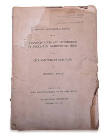
1908 Report on Proposed New York / New Jersey New Railway SystemRail & Road Auctions4.6(165)See Sold PriceMar 08, 2024
Rand McNally & Co's New Ideal State and County Survey and Atlas 1911North American Artifact Auctions4.7(198)See Sold PriceApr 20, 2024
1849 THE NEW-ENGLAND MERCANTILE UNIONNorth American Artifact Auctions4.7(198)See Sold PriceApr 20, 2024
[ARCTIC]. BOWEN, Emanuel. A New & Accurate Map of the North...Potter & Potter Auctions4.6(545)See Sold PriceMar 07, 2024
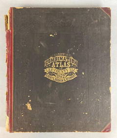
1872 New Combination Atlas of Lee County Illinois BookMatthew Bullock Auctioneers4.7(1.8k)See Sold PriceFeb 24, 2024
1750 Bowen Map of Bermuda and St. Kitts -- A New & Accurate Map of Bermudas or Sommer's Islands...Jasper524.5(9.9k)See Sold PriceFeb 27, 2024
Herman Moll A New Map of Ye North Parts of AmericaWillow Auction House4.5(289)See Sold PriceMar 14, 2024


![[MAPS] Sands & McDougall Map of Melbourne and Suburbs (1 of 3)](https://p1.liveauctioneers.com/8597/296734/157735916_1_x.jpg?height=282&quality=70&version=1690170365)


![5 Maps [Ca. 1646] - 1804: England, northern Europ (1 of 5)](https://p1.liveauctioneers.com/179/12368/3396980_1_x.jpg?height=282&quality=70&version=1175725014)


![[ARCTIC]. BOWEN, Emanuel. A New & Accurate Map of the North... (1 of 1)](https://p1.liveauctioneers.com/928/318880/171360917_1_x.jpg?height=282&quality=70&version=1707501302)