SoldA monochromatic map of the 'Countie of Radnor describedA monochromatic map of the 'Countie of Radnor described and the Shyretownes sittauatione' dated 1618 described by Christopher Saxton, augmented and published by John Speed. 52 x 39cmSee Sold Price
SoldMap, Speed, John, London, 1610MAP. Speed, John, The Countie of Radnor Described and the Shiretownes Sittuatione Anno 1610, London, Publisher: John Sudbury & George Humble, 1611-[1614-16], Copper-engraved map. 38x50.5 cm. (15x19¾"See Sold Price
SoldA monochromatic map of 'The Countie of Nottingham'A monochromatic map of 'The Countie of Nottingham' described 'The Shire Townes Situation and the Earls thereof observed' by John Speed and dated c1610. 52 x 40cm. Slightly AF to centrefold.See Sold Price
SoldSpeed (John) The Countie of Radnor DescribedSpeed (John) The Countie of Radnor Described,county map, with inset vignette of Radnor upper left, strapwork carouches with armorials lower corners, engraving, with woodcut initial by John DawSee Sold Price
Speed (John) The Countie of Radnor DescribedSpeed (John) The Countie of Radnor Described,county map, with inset vignette of Radnor upper left, strapwork carouches with armorials lower corners, engraving, with woodcut initial by John DawSee Sold Price
SoldSpeed. The Countie of Radnor Described. c.1612.[Wales] Speed, John. “The Countie of Radnor Described and the Shiretownes Sittuatione.” London, John Sudbury and George Humble, c. 1612. Engraved map. 20 1/8” x 15 1/8”. FramedSee Sold Price
Speed map of County Radnor, WalesTitle: The Countie of Radnor Described and the Shiretownes Sittuatione Anno 1610 Author: Speed, John Description: Copper-engraved map. 38x50.5 cm. (15x19¾"). Speed's map of Radnor County in eastern WSee Sold Price
Speed (John) 4 Welsh county mapsSpeed (John) Merionethshire Described; The Countye of Monmouth; The countie of Radnor described,3 Welsh county maps, with a duplicate of Radnor, each with an inset plan, decorative strapwork cSee Sold Price
SoldSPEED, John (1551-1629). The Countie of Radnor DescribeSPEED, John (1551-1629). The Countie of Radnor Described and the Shyretownes Sittuatione. [London,] 1618. Engraved map, English text on verso, visible area 15 1/2 x 20 1/2 in. (400 x 520 mm). Matted aSee Sold Price
SoldMap The Countie of RadnorDescribed and the Shyretownes Sittuatione, anno 1610. 15 3/4"h x 20 1/2"wSee Sold Price
SoldChristopher Saxton after Speede and Hondius, 'THE COUNTChristopher Saxton after Speede and Hondius, 'THE COUNTIE OF RADNOR DESCRIBED', with printed back, 40 x 51.5cmSee Sold Price
Sold1610 Map of Nottingham by Cartographer John SpeedHistoric Maps 1610 Map "The Countie of Nottingham described..." by Cartographer John Speed & Engraved by Jodocus Hondius 1610-Dated, Hand-Colored English Map titled: "The Countie of Nottingham describSee Sold Price
SoldAntique map Jansson GermanUnframed antique map, ''Radnoriensis/The Countie of Radnor'', by Johannes (Janssonius) Jansson (German, 1596-1666), sheet: 18.5''h x 23.25''wSee Sold Price
Sold1610-1676 John Speed Hand Colored Map1610-1676 John Speed hand colored 21 1/4" x 16 1/2" Map, "Norfolk, A Countie Flourishing & Populous Described and Divided with the Arms of Such Noble Families As Have Borne The Titles Thereof", From SSee Sold Price
SoldA largely monochromatic map of the county of Sussex 'A largely monochromatic map of the county of Sussex 'described by John Norden, augmented by John Speede..' 50 x 39cmSee Sold Price
SoldA monochromatic map of Rutlandshire with ' Oukham andA monochromatic map of Rutlandshire with ' Oukham and Stanford', her bordering neighbour Newely described by John Speed c1676, 51 x 38cm.See Sold Price
Speed Map of NottinghamSpeed, John (1551-1629). The Countie of Nottingham described... Engraved map with original hand color. London: Humble, 1610. 18 1/4" x 21 3/4" sheet. Attractive full color example of Speed's map of NoSee Sold Price
SoldA lot of two 17th century colored maps by Saxton and Hondius2 (Two) seventeenth century colored maps, the first Saxton's "Norfolk a Countie Florishing & Populous Described and Devided with the Armes of such Noble Familes as have Borne the Titles Therof" mid 17See Sold Price
SoldChristopher Saxton/The Countie of Radnor Anno 1618/TheChristopher Saxton/The Countie of Radnor Anno 1618/The County of Hereford/Frugiferi Ac Ameni Herefordshire/three hand coloured engraved mapsSee Sold Price
Jansson (Jan) Radnoriensis Comitatus vulgo The CouJansson (Jan) Radnoriensis Comitatus vulgo The Countie of Radnor,decorative title cartouche lower left, and scale cartouche lower right, engraved map, with outline hand-colouring, 380 x 480mm.See Sold Price
SoldA framed and glazed John Speed Staffordshire handA framed and glazed John Speed Staffordshire hand coloured engraved map, 'Stafford, Countie and Towne with the ancient Citie Lichfeild described' 15 x 20 (38cm x 51cm), together with another hand coloSee Sold Price
SoldThree European Hand-Colored MapsThree Antique European Hand-Colored Maps , 18th c., incl.: "The Countie and Citie of Lyncolne Described with the Armes...", 15 in. x 20 in.; "Istria olim Iapidia", 15 in. x 19 1/2 in.; and "PrincipatuSee Sold Price
SoldJ. Speed map- map of Nottingham, EnglandCartographer: John Speed Title: The Countie of Nottingham described The Shire Townes Situation and the Earls thereof observed Subject: Nottingham, England Published: London: Roger Rea the Elder and YoSee Sold Price
1610 English Map of the County of NottinghamPrint. Includes six family coats of arms, "The Countie of Nottingham described", and a detailed map of the town of Nottingham. Length 11 Inches Width 14.5 InchesSee Sold Price
17TH C. MAP OF THE BERKSHIRES BY JOHN SPEED, FRAMEDThomaston Place Auction Galleries4.4(393)See Sold PriceFeb 24, 2024
Museum of Horrors - King of Pigs -Emil Zola - 1899Levy Auction House4.3(11)See Sold PriceFeb 27, 2024
Illustrated Sabbath Cloth - Holy Sites of Eretz IsraelLevy Auction House4.3(11)See Sold PriceFeb 27, 2024
Audubon - 8 Quadruped LithographsTrillium Antique Prints & Rare Books4.5(32)See Sold PriceFeb 24, 2024
Catesby, Folio - American Goldfinch with Acacia. 1-43Trillium Antique Prints & Rare Books4.5(32)See Sold PriceFeb 24, 2024
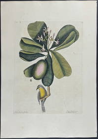
Catesby, Folio - Bahama Titmouse with Seven Years Apple. 1-59Trillium Antique Prints & Rare Books4.5(32)See Sold PriceFeb 24, 2024
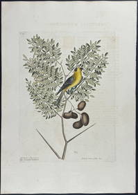
Catesby, Folio - American Partridge with Attamusco Lily. Sup-12Trillium Antique Prints & Rare Books4.5(32)See Sold PriceFeb 24, 2024
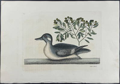
Catesby, Folio - Little Brown Duck with Soap-Wood. 1-98Trillium Antique Prints & Rare Books4.5(32)See Sold PriceFeb 24, 2024
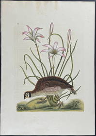
Catesby, Folio - Red Bellied Woodpecker & Hairy Woodpecker with Black Oak. 1-19Trillium Antique Prints & Rare Books4.5(32)See Sold PriceFeb 24, 2024
Map: An engraved and hand coloured map titled The Countie of Nottingham described The Shire TownesClaydon Auctioneers Ltd4.3(125)See Sold PriceFeb 26, 2024
Pre-colonial Africa. Mountains of Kong/Moon. Caravan routes. THOMSON 1817 mapJasper524.5(9.9k)See Sold PriceFeb 28, 2024
AFRICA. Shows Mountains of Kong/the Moon. Caravan routes. RAPKIN/TALLIS 1851 mapJasper524.5(9.9k)See Sold PriceFeb 28, 2024
Central Africa. Map showing great forest traversed by Mr Stanley, 1890Jasper524.5(9.9k)See Sold PriceFeb 28, 2024