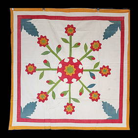
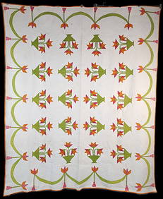
SoldA Folky Map Of The United States QuiltTitle: A FOLKY MAP OF THE UNITED STATES QUILT Size: 80" wide x 76" high Material: cotton Maker: unknown Provenance/Additional Info: A charming uncommon quilt that shows the 48 states each identified wSee Sold Price
A FOLKY MAP OF THE UNITED STATES QUILTTitle: A FOLKY MAP OF THE UNITED STATES QUILT Provenance/Additional Info: 80" wide x 76" highcottonmaker unknownA charming uncommon quilt that shows the 48 states each identified with their abbreviatiSee Sold Price
20th C United States Map Pieced QuiltItem: United States Map Pieced Quilt Date: ca. 1940's Size: 76 inches high x 80 inches wide Description: Each state has abbreviated name written in ink, most states bound in pale pink and sewn to jeweSee Sold Price
SoldMap, United States, 1784, first map of the nationMap, United States, 1784,"Carte Des Etats-Unis De L'Amerique Suivant le Traite de Paix de 1783. Dediee et Presentee A.S. Excellence M. Benjamin Franklin Ministre Pleinipotentaire des Etats-Unis", theSee Sold Price
SoldJohn Haven Map: United States and MexicoNew York: Haven & Emmerson, 1846 wood engraved, hand colored map created during the time of the Mexican American War. The map shows the United States and Mexico and includes the Oregon Territory, TexaSee Sold Price
SoldTallis, John (Pub) 1852 Map. United StatesSteel Engraved Map Published 1852-56 by John Tallis, London for "The Universal Pronouncing Dictionary" by Thomas Wright. Drawn & Engraved by John Rapkin. Centre fold as issued. Paper Size: 13.5 x 10.5See Sold Price
SoldAntique map, "United States of America", by JohnAntique map, "United States of America", by John Melish, 1818, Compiled from the latest and best authorities, 16.25" by 19.5". Notice: Please note that our auctions will continue in the online only foSee Sold Price
SoldWilkes, John 1797 Map. United StatesCopper Engraved Map Published 1796-1828 London for "Encyclopaedia Londinensis, or universal dictionary of arts, sciences and literature" by John Wilkes et al. Paper Size: 10.5 x 8.5 inch (27 x 22cm) GSee Sold Price
SoldAN ANTIQUE MAP, "United States (South Central),"AN ANTIQUE MAP, "United States (South Central)," LIVERPOOL, GREAT BRITAIN, 1891-1917, a color engraving on paper,"Philips' Authentic Imperial Maps for Tourists and Travelers," printed by George PhilipSee Sold Price
SoldGEOLOGICAL MAP UNITED STATESGEOLOGICAL MAP UNITED STATES Height: 22 in. by Width: 19 in.See Sold Price
SoldAntique Map United States Thomson's 1817Antique Map United States Thomson's 1817, authentic antique map, inscribed, "drawn & engraved for Thomson's new general atlas 1817", along with "Northern Provinces of the United States", hand coloredSee Sold Price
SoldGuthrie, William 1798 Map. United States of America"The United States of America according to the Treaty of Peace of 1784" Copper Engraved Map Published 1798, London for "A New Geographical, Historical and Commercial Grammar..." by William Guthrie. ThSee Sold Price
SoldJohn Cary, Map United States, Treaty of Peace 1783John Cary (London, 1754-1835) "An Accurate Map of the United States of America, with Part of the Surrounding Provinces agreeable to the Treaty of Peace of 1783", 1783 (created/published) Hand coloredSee Sold Price
Sold18thc Map: United States of America, Wilkes, 1797Framed antique map, United States of America, Published London 1797 by J. Wilkes. Engraved by Neele, 352 Strand, London. Hand colored, the map shows the United States in the Decade after the AmericanSee Sold Price
SoldMap United States, Henry Bostwick, NY 1825Hand colored map of United States from atlas published by Henry Bostwick, NY, 1825. 18" high, 26" wide. Conditon: as is.See Sold Price
SoldA MAP, UNITED STATES OF AMERICA, J. CALVIN SMITH, NEW YA MAP, UNITED STATES OF AMERICA, J. CALVIN SMITH, NEW YORK, SHERMAN & SMITH, 1846, for travelers showing the railroad, canals and stage roads with distances. 22" x 26". Framed. NOTE: scale ca. 1:4, 25See Sold Price
SoldMap - "United States & Canada" - Carte GendraleMap - "United States & Canada" - Carte Gendrale - Paris, 1825See Sold Price
SoldWorld At War Map : United States As A World PowerThe World War Historical Map by Sanford – Gordy. Map shows the Nations At War. The League Of Nations and the United States As A World Power, After the Spanish American War. Colonial with PossessionsSee Sold Price
SoldAN ANTIQUE HAND COLORED MAP, "United States and Texas,"AN ANTIQUE HAND COLORED MAP, "United States and Texas," CIRCA 1843, engraving on paper with hand coloring and small map, "Stretch of the River Niagara," plate thirty nine, published "Edinburg, John JSee Sold Price
SoldAN ANTIQUE MAP, "United States of America," NEW YORK,AN ANTIQUE MAP, "United States of America," NEW YORK, 1827, hand colored engraving on paper, engraved by Benjamin Tanner (1775-1848). 17" X 21 5/8" Note: This map unusually shows two locations for GalSee Sold Price
SoldAN ANTIQUE MAP, "United States," BOSTON, CIRCA 1838,AN ANTIQUE MAP, "United States," BOSTON, CIRCA 1838, hand colored engraving on paper, showing Texas as an independent nation, a page fragment from an atlas, Thomas Gamaliel Bradford (1802-1887) cartogSee Sold Price
Sold[Map] United States Department of Interior[Map] United States Department of Interior , "Plan and Profile of Colorado River from Leese Ferry, Ariz, to Black Canyon, Ariz, Nev, and Virgin River", 1923, 18 in. x 25 in (21pcs) Provenance: PropertSee Sold Price
SoldAN ANTIQUE MAP, "United States of North America,AN ANTIQUE MAP, "United States of North America, Southwest Sheet," 1893-1912, color engraving on paper, engraved, printed and published by W. & A.K. Johnston, Edinburgh and London, showing parts BajaSee Sold Price
American Express/New York Central Railroad Map of the United States-1934JM Hobby Supply and Railroad Artifact Auctions4.4(126)See Sold PriceFeb 24, 2024
Union Pacific RR Map of the United States-1926JM Hobby Supply and Railroad Artifact Auctions4.4(126)See Sold PriceFeb 24, 2024
United States Map with American Flag 3-D Wall Mount PaintingWeatherham Estate Treasures3.9(157)See Sold PriceFeb 29, 2024
1905 20th Century Atlas of Boone County IllinoisMatthew Bullock Auctioneers4.7(1.8k)See Sold PriceFeb 24, 2024
Arrowsmith & Lewis - Map of the United StatesTrillium Antique Prints & Rare Books4.5(30)See Sold PriceFeb 24, 2024
Mitchell - Map of the City of Washington (Washington, DC)Trillium Antique Prints & Rare Books4.5(30)See Sold PriceFeb 24, 2024
Cooke, George 1801 Antique Map. United States of AmericaAlbion Auctions4.6(336)See Sold PriceMar 01, 2024
Blackie (Pub) 1882 Folio Map. United States of North AmericaAlbion Auctions4.6(336)See Sold PriceMar 01, 2024
Map of United States of North America, 1785Antiques Online Auctions4.6(407)See Sold PriceMar 14, 2024
Vintage 1920s Rand McNally Auto Trails MapThe Benefit Shop Foundation Inc.4.3(2.9k)See Sold PriceMar 20, 2024


![[Map] United States Department of Interior (1 of 2)](https://p1.liveauctioneers.com/268/180010/90586238_1_x.jpg?height=282&quality=70&version=1600794544)


