SoldA 1935 Map of Facts & Points of Interest in MichiganA fiendly service map of the Common Wealth of Michigan, colored map of the facts and points of interest in Michigan, copyrighted 1935 by Hy Richardson, 25" H x 21.25" W framed.See Sold Price
1935 (circa) A Map of the Commonwealth of MichiganBy: H. Richardson Date: 1935 (circa) Dimensions: 22.5 x 18.5 inches (57.2 cm x 47 cm) This brightly colored, attractive pictorial map of Michigan includes many of the main points of interest of the stSee Sold Price
SoldVINTAGE MAPS AND MOREVINTAGE MAPS - UTAH OIL REFINING COMPANY - WESTERN STATES - SHELL - MAP OF NEVADA/UTAH AND ARIZONA/NEW MEXICO - RPM MOTOR OIL MAP - CALIFORNIA POINTS OF INTEREST AND TOURING MAP - AND MANY MORE - ALLSee Sold Price
SoldGuide to Virginia City For the Serious TouristSelf guided tour "for the serious tourist" published by Pages of History in 1959. Booklet is 55 pages, with folded 22 x 17 inch color map. Each point of interest is described with history and drawn ilSee Sold Price
SoldGarmin Street Pilot 2720Comes in the original box with accessories and remote. internal antenna communicates with up to 12 GPS satellites Database of preloaded maps and points-of-interest Automatic route recalculation if youSee Sold Price
SoldVintage Lithograph Map of Odessa RussiaVintage map of Odessa Russia, map displays various points of interest with an index on the back with corresponding information to each number on the map, lithographic map, some wear and tear to edgesSee Sold Price
SoldVintage Lithograph Map of Odessa RussiaVintage map of Odessa Russia, map displays various points of interest with an index on the back with corresponding information to each number on the map, lithographic map, some wear and tear to edgesSee Sold Price
SoldVintage Lithograph Map of Odessa RussiaVintage map of Odessa Russia, map displays various points of interest with an index on the back with corresponding information to each number on the map, lithographic map, some wear and tear to edgesSee Sold Price
SoldThe Visitor's Guide to the World's ExpositionThe Visitor's Guide to the World's Exposition, lithographed guide of the City of New Orleans with a street map highlighting various points of interest throughout the city, printed in 1884 by the SouthSee Sold Price
SoldBaltimore, Maryland 1936 Points of Interest MapBaltimore, Maryland 1936 Points of Interest Map With Main Traffic Routes. the Item Is in Good Condition. Please note that this lot has a confidential reserve. When you leave a bid in advance of the auSee Sold Price
Sold1815 Battle of Waterloo Folding Map1815 Plan de la Bataille de Waterloo hand colored folding map on paper, showing points of interest and army positions, index in French & English, created by H. Gerard. CONDITION: Personalized presentaSee Sold Price
SoldOriginal Travel Poster USA Scandinavian AirlinesOriginal vintage Scandinavian Airlines System travel poster for USA by SAS featuring a fun and colourful pictorial map design depicting various points of interest and notable landmarks, sports and othSee Sold Price
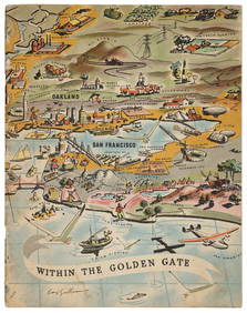
Sold1930's Bay Area Survey Maps(lot of 6) (3) San Joaquin River (1933/1936), Sacramento River (1926), Suisun Bay (1935), and Pfeiffer Point to Cypress Point (1935) Survey Maps, Published in Washington D.C. by the U.S Coast and GeodSee Sold Price
Sold1930's Bay Area Survey Maps(lot of 6) (3) San Joaquin River (1933/1936), Sacramento River (1926), Suisun Bay (1935), and Pfeiffer Point to Cypress Point (1935) Survey Maps, Published in Washington D.C. by the U.S Coast and GeodSee Sold Price
New Map of Boston Giving All Points of Interest; ...Title/Content of Map: New Map of Boston Giving All Points of Interest; ... Date: 1920 ca. Cartographer: WALKER LITH. & PUB. CO. Size: 18.6X17 Large three color plan of the city. Folding into tan wrappSee Sold Price
New Map of Boston Giving All Points of Interest; ...Publication Date: c1920 Title: New Map of Boston Giving All Points of Interest; ... Cartographer: WALKER LITH. & PUB. CO. Height: 18.6Width: 17 Large three color plan of the city. Folding into tan wraSee Sold Price
SoldEdinburgh, Scotland 1940's Map/Bus Routes/Golf CourseEdinburgh, Scotland 1940's Map/ Bus Routes/ Golf Courses/ Points of Interest, Travel Guide. the Item Is in Good Condition. Please note that this lot has a confidential reserve. When you leave a bid inSee Sold Price
SoldSouthern Pacific Railroad and Rock Island Advertisements for The Californian - 1937 to 1940A small group of Southern Pacific Railroad and Rock Island Advertisements. Includes an informational brochure for The Californian Route with photos and a map of the US with points of interest such asSee Sold Price
SoldSecurity Savings Bank map of Los Angeles 1910 rareHeading: (California - Los Angeles) Author: Title: "Security" Map and Street Railway Guide of the City of Los Angeles and Vicinity with Map of Beaches and Nearby Points of Interest Place Published: LSee Sold Price
Brfeast Pocket Map of Boston 1903Title: New Map of Boston, giving all points of interest with every railway & steamboat terminus, prominent hotels, theatres & public buildings Author: ** Description: Map printed in red & black, on thSee Sold Price
Brfeast Pocket Map of Boston 1903Title: New Map of Boston, giving all points of interest with every railway & steamboat terminus, prominent hotels, theatres & public buildings Author: ** Description: Map printed in red & black, on thSee Sold Price
1940s Indiana Pictorial Travel Map -- See IndianaTitle/Content of Map: 1940s Indiana Pictorial Travel Map -- See Indiana Date: 1940sCartographer: Size: 22 X 17 in. This is a fascinating pictorial map of Indiana showing many points of interests - somSee Sold Price
SoldBlack Hills Their Wonderful Mineral WealthTitle: The Black Hills Their Wonderful Mineral Wealth and Products. Rapid City, the Gateway and Distributing Point; Facts and Figures of Interest to All (cover title) Author: ** Description: 16 pp. 3See Sold Price
Sold1940s Indiana Pictorial Travel Map -- See IndianaTitle/Content of Map: 1940s Indiana Pictorial Travel Map -- See Indiana Date: 1940s Cartographer: Size: 22 X 17 in. This is a fascinating pictorial map of Indiana showing many points of interests - soSee Sold Price
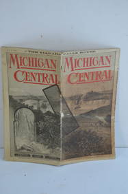
Two Michigan Central RR Annual Reports-June 1860 and December 31, 1897JM Hobby Supply and Railroad Artifact Auctions4.4(127)See Sold PriceFeb 24, 2024
Michigan Southern and Northern Indiana RR 14th Annual Report-February 28, 1869JM Hobby Supply and Railroad Artifact Auctions4.4(127)See Sold PriceFeb 24, 2024
Michigan Central RR May 18, 1884 Public TimetableJM Hobby Supply and Railroad Artifact Auctions4.4(127)See Sold PriceFeb 24, 2024
1937 Holland, Michigan, Tulip Time Map Guide, FramedLakeshore Event Center4.6(106)See Sold PriceMar 02, 2024
1849 Mitchell School ATLAS 24 MAPS America Holy Land France Africa Egypt AsiaSchilb Antiquarian Rare Books4.8(428)See Sold PriceMar 31, 2024
Thirty Pieces of Lackawanna Railroad Ephemera - Chief Engineer Timebook, Map, Public Timetables,Rail & Road Auctions4.6(165)See Sold PriceMar 07, 2024
1855 Guide for the Pennsylvania Railroad with an Extensive Map from the Pennsylvania RailroadRail & Road Auctions4.6(165)See Sold PriceMar 07, 2024
Rand McNally Railroad Map Cabinet w/ 21 Railroad MapsRail & Road Auctions4.6(165)See Sold PriceMar 08, 2024
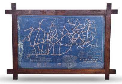
New York, New Haven and Hartford Railroad Framed Car Clearance Blue Prints Revised 1935Rail & Road Auctions4.6(165)See Sold PriceMar 08, 2024
[POSTCARDS]. [R.M.S. TITANIC]. Mailed 1913 RPPC of “Titanic...Potter & Potter Auctions4.6(545)See Sold PriceMar 07, 2024
Moore & Seeburger Coal Blissfield Michigan FORD Advertising Calendar SignHoller and Hammer4.6(64)See Sold PriceFeb 25, 2024
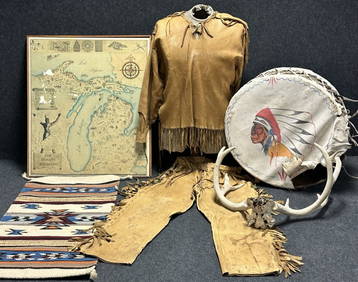
Antique Native American 5 Piece Lot: Deerskin Jacket & Pants, Rug, Drum, Michigan Map & Mule DeerHoller and Hammer4.6(64)See Sold PriceFeb 24, 2024
Carey, pub. 1796 - Map of GeorgiaTrillium Antique Prints & Rare Books4.5(32)See Sold PriceFeb 24, 2024
Carey, pub. 1796 - Map of KentuckyTrillium Antique Prints & Rare Books4.5(32)See Sold PriceFeb 24, 2024
Carey, pub. 1796 - Map of the Tennassee State formerly part of North Carolina (Tennessee)Trillium Antique Prints & Rare Books4.5(32)See Sold PriceFeb 24, 2024
Framed Space Age Rand McNally Map of Planets Poster, 1958PUBLIC SALE4.7(226)See Sold PriceMar 02, 2024


![[POSTCARDS]. [R.M.S. TITANIC]. Mailed 1913 RPPC of “Titanic... (1 of 1)](https://p1.liveauctioneers.com/928/318880/171361156_1_x.jpg?height=282&quality=70&version=1707501302)