Sold9 maps: Britain, Europe, US. 3 hand-colored.[Miscellany]. 9 Maps. Most approx. 13 x 19 in. ++ Hand-colored panorama of a city, c.17th cent. ++ 5 military maps with bottom margin labelled ''For Mr. Tindal's Continuation of Mr. Rapin's History ofSee Sold Price
Sold30 maps [c1700-1875]: Europe, cities, battles.[Europe]. About 30 Maps. C.1700-1875. ++ 3 maps from same source with hand-colored outline and cartouche. 7 3/8 x 9 7/8 in. Includes: (1) Joshua Hickman; map of Scandanavia, Germany, and Baltic regionSee Sold Price
SoldTHREE 18TH/19TH C. MAPSIncluding Europe and Great Britain; Engravings on paper, two hand colored (framed); Largest: 19 3/4" x 22 1/2"See Sold Price
Sold8 Maps incl: Carte Particuliere de la Moravie.[Europe/New England/Carribean]. 8 Maps. Smallest: 6 7/8” x 9”. Largest:19 ¾” x 25 ¼”. Maps. 3 are matted (margins not examined). Versos not examined. First 5 have hand-colored outline. ++ CaSee Sold Price
SoldGrp: 9 Maps of FranceGroup of nine maps of France and other parts of Northern Europe. Hand Colored Map of the Netherlands "Les Provinces Unies des Pays-Bas" 1672; Nicolas Sanson (1600-1667) Hand Colored Map of "Les Deux BSee Sold Price
Sold[U.S. CITIES]. 3 hand-colored lithograph maps[U.S. CITIES]. 3 hand-colored lithograph maps featuring 6 cities, published by J.H. Colton, NY, 1855. ++ St. Louis [and] Chicago. Margins slightly toned. ++ Pittsburgh [and] Cincinnati. Margins slightSee Sold Price
Sold160 maps Britain, Ireland, Europe, c.1800-1911.[British Isles/Europe]. About 167 maps, mostly in color (hand and printed). About 18 of Holland and Belgium; 32 other Continental maps (mostly general maps of Europe); 5 engraved hand-colored maps ofSee Sold Price
Sold5 maps: British, European locales.[Europe/Britain]. 5 Maps. 4 are hand-colored (fully or outline). ++ Robert Morden. Poland. (Title from cartouche.) At outer border: 4” x 4 7/8”. The map occupies most of a page which has the headiSee Sold Price
SoldMaps of the U.S. (3) (63544)1) North America, 1884. Hand colored by Mitchell. Approximately 12" x 15." 2) New Hampshire by Rand McNally, 1888. Graphics and color by lithography. Approximately 15" x 22." 3) Kentucky & Tennessee,See Sold Price
Sold3 Maps by De Rossi: Scandinavia, Russia, Prussia.[De Rossi/Scandinavia/Eastern Europe] 3 Maps from an edition of Giovanni Giacomo de Rossi’s “Mercurio Geografico Overo Guida Geografica in Tutte le Parti del Mondo.” Hand colored outline. DoubleSee Sold Price
Sold19th & Early 20thc Maps of EuropePair of original maps of Europe. - a hand-colored, reference Map ( No.14 ) of Central Europe, from THE COMMON-SCHOOL GEOGRAPHY - 1873 - early 20thc fold-out Map of Europe measuring British miles. 9" XSee Sold Price
Sold4 Maps: Luxemburg, etc. 2 hand colored. Ca. 18th[EUROPE]. 4 Maps. Good - very good condition, defects noted below. All but one is double-page engravings (3 hand-colored). ++ Danckerts. Ducatus Lutzenburgi Nova et Accurata Tabula cum Adjacentibus PrSee Sold Price
SoldTwo Justus Perthes Maps, 19th C.Maps created by cartographer Justus Perthes (German 1749-1816). One hand colored map of Europe, the other of Great Britain. Europe map with "Imperium Romanotum post divisionem in Occidentale & OrientaSee Sold Price
Sold3 Hand Colored Maps of Syria, Palestine & Europe3 Hand Colored Maps of Syria, Palestine & Europe. Dimensions of Largest- Sight- L-15" x W-20", Frame- L- 20" x W-23.5".See Sold Price
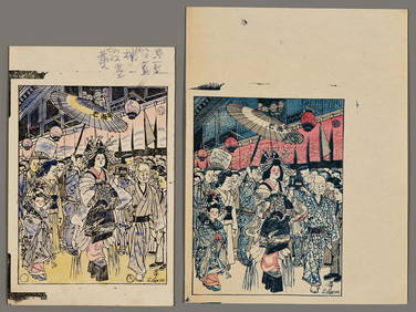
Sold4 maps of china [c1600-1787]. 3 handcolored OL.[China]. 4 engraved maps. Very good condition overall. ++ Cellarius? Imperii Sinarum Nova Descriptio. c.1720-1750s? 7 1/8 x 9 7/8 in. Contemporary hand-colored in outline and to cartouche. ++ RigobertSee Sold Price
SoldEngraved hand colored maps, Scotland, Britain(Lot of 3) Framed engraved hand colored maps, 18th and 19th centuries, ''O Rcadum et Schetlandiae,'' an English map, including Lincolnshire Derby, Stafford, Notingham, and ''The Occidental and OrientaSee Sold Price
SoldHand Colored Celestial 1844 Framed MapHand Colored Celestial 1844 Framed Map: Map Done by E.H. Butler. Old Glass and Frame, New Mat. Has Fold in Map with Some Staining. 9"x 14" Map in 3" Mat and 1 3/4" Frame with Gold Liner.See Sold Price
SoldSebastian M¸nster "Die Stat Florentz" hand coloredSEBASTIAN M‹NSTER (German 1488-1552) "Die Stat Florentz" (possibly from Munster's Casmographia) Hand colored woodblock map Sight: 9 3/4 x 14 5/8 inches; Frame19 3/4 x 24 1/2 inches. Latin text versoSee Sold Price
Sold9 Vols incl: Knight. OLD ENGLAND. Vol II.[Britain] 3 Titles (9 Vols). 8vo/folio. Sold with all faults. ++ Charles Knight. OLD ENGLAND. Vol II (of 2). Lon: James Sangster and Co., (nd). v, [1], 404 pp. 22 hand-colored plates, many b/w text ilSee Sold Price
Sebastian M¸nster "Die Stat Florentz" hand coloredSEBASTIAN M‹NSTER (German 1488-1552) "Die Stat Florentz" (possibly from Munster's Casmographia) Hand colored woodblock map Sight: 9 3/4 x 14 5/8 inches; Frame19 3/4 x 24 1/2 inches. Latin text versoSee Sold Price
SoldGrp: 3 Maps of EuropeGroup of three maps of Europe. Includes one hand colored map of the Netherlands by Herman Moll (1654-1732), "A New Map of the United Provinces of Netherlands &c." London: Herman Moll, ca. 1701; one DuSee Sold Price
SoldHAND COLORED ANTIQUE MAPS, EUROPE & THE WORLDHAND COLORED ANTIQUE MAPS, 3, INCLUDING JOHANN BAPTIST HOMANN & JACOBO MARCELLO, EUROPE & THE WORLD:11 1/8" x 20 1/4", 19" x 22 1/8", 19" x 23 1/4"; unframed. Ex. Collection Nancy and the late G. MennSee Sold Price
SoldMap of Louisiana, February 3, 1866, hand coloredMap of Louisiana, February 3, 1866, hand colored Harper's Weekly print, presented in a green and gilt frame, H.- 14 1/4 in., W.- 9 3/4 in. Provenance: The Estate of Lawrence Bres Eustis, New Orleans,See Sold Price
Sold9" x 10 1/2" hand colored map of Eastern US ca 1859" x 10 1/2" hand colored map of Eastern US ca 1850See Sold Price
LATE 18TH C. VERY LARGE CHART OF NORTHEAST CANADA BY DES BARRES (1721-1824), 1780, FRAMEDThomaston Place Auction Galleries4.4(386)See Sold PriceFeb 24, 2024
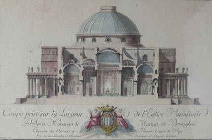
Charles Dupuis French 18th century, Pair Hand Colored Engravings, ArchitecturalGlobal Auctions Company4.3(36)See Sold PriceMar 03, 2024
(13) 19th C. Prints Great Homes of Britain PrintsEpic Auctions and Estate Sales4.6(204)See Sold PriceMar 02, 2024
ANTIQUE AMERICAN CIVIL WAR HAND COLORED LITHOGRAPHSAntique Arena Inc.4.5(852)See Sold PriceFeb 24, 2024
[PHOTOGRAPHY]. A Group of 32 Cabinet Cards and 34 Real Phot...Potter & Potter Auctions4.6(539)See Sold PriceMar 07, 2024
Hand Colored Engraved Map of Europe, Jean Baptiste Bourguignon Anville 1754Global Auctions Company4.3(36)See Sold PriceMar 03, 2024
Donovan's The Natural History of British Shells - 5 Volumes in 3 Books with 180 EngravingsTrillium Antique Prints & Rare Books4.5(30)See Sold PriceFeb 24, 2024
Currier and Ives (American) Hand Colored Lithograph " Wild Turkey Shooting"CV Auction LLC4.4(34)See Sold PriceMar 09, 2024
ROBERT WINSLOW (America, Early 20th Century), Three Provincetown views:, Hand-colored photographs,Eldred's4.7(409)See Sold PriceMar 07, 2024
Two Hand-Colored 19th Century Maps of New Orleans and Louisiana, Larger- H.- 12 1/2 in., W.- 15 1/2Crescent City Auction Gallery4.3(229)See Sold PriceMar 08, 2024
Zenith Chronomaster Sport 41mm Steel Mens WatchGolden Gate Auctioneer4.1(273)See Sold PriceFeb 24, 2024
1849 Hand Colored Blair Map of World in HemispheresMatthew Bullock Auctioneers4.7(1.8k)See Sold PriceMar 02, 2024
1849 Orr & Co. Hand Colored Southern Germany MapMatthew Bullock Auctioneers4.7(1.8k)See Sold PriceMar 02, 2024
1821 TAKINGS OR COLLEGIAN LIFE 26 ANTIQUE ETCHINGS ILLUSTRATED BY A POEM, FIRST EDITION.NY Elizabeth 4.3(84)See Sold PriceMar 03, 2024
2 CAST IRON AMISH FAMILIES AND FIREMAN WAGON TOYSAntique Arena Inc.4.5(852)See Sold PriceJun 15, 2024


![30 maps [c1700-1875]: Europe, cities, battles. (1 of 2)](https://p1.liveauctioneers.com/179/14187/4432338_1_x.jpg?height=282&quality=70&version=1193335524)


![[U.S. CITIES]. 3 hand-colored lithograph maps (1 of 1)](https://p1.liveauctioneers.com/179/10971/2682774_1_x.jpg?height=282&quality=70&version=1162265652)


![4 maps of china [c1600-1787]. 3 handcolored OL. (1 of 1)](https://p1.liveauctioneers.com/179/15522/5074082_1_x.jpg?height=282&quality=70&version=1206672512)


![[PHOTOGRAPHY]. A Group of 32 Cabinet Cards and 34 Real Phot... (1 of 1)](https://p1.liveauctioneers.com/928/318880/171361555_1_x.jpg?height=282&quality=70&version=1707501302)