Sold4 framed maps - The World, Europe, Asutria, Turke4 framed maps - The World, Europe, Asutria, Turkey and Greece, 19/20thc reproductions of earlier maps, framed, average overall size 20" x 26 1/2"See Sold Price
Soldprint Map EuropeFramed offset print, ''Poloniae'', published 1938 for distribution at the New York World's Fair, overall: 14 1/4''H x 18 1/4''W.See Sold Price
SoldCortambert, Eugene 1874 Lot of 4 Maps. UK, World EuropeTwo of the British Isles, Europe Physical Map and World on Mercators Projection. Hand Coloured Lithograph Maps Published 1874, Paris for "Atlas de la Geographie de L'Europe" by Eugene Cortambert. PapeSee Sold Price
SoldPAIR OF FRAMED WORLD MAPSPAIR OF FRAMED MAPS - "THE WORLD SHOWING COMMERCIAL HIGHWAYS" & "EUROPE" Height: 22 in. by Width: 30 in.See Sold Price
SoldPAIR OF FRAMED WORLD MAPSPAIR OF FRAMED MAPS - "THE WORLD SHOWING COMMERCIAL HIGHWAYS" & "EUROPE" Height: 22 in. by Width: 30 in.See Sold Price
SoldCoaching Scene Print and World MapCoaching scene print, 'Down Hill, The Skid', published London May 20, 1867, 18" x 25" (view), 26 3/4" x 33 3/4" (framed), together with map of the world print published 1791, 17 1/2" x 13 1/2" (framedSee Sold Price
SoldEuropae (from Novus Atlas)Henricus Hondius. copperplate engraving with very fine original handcoloring. Amsterdam, 1631. 18 1/4 x 22 1/4 inches, 29 1/2 x 33 3/4 inches framed. A Splendid Map of Europe from the Golden Age of DuSee Sold Price
SoldGoeree Map of the WorldDe Aard-Kloot Volgens de Hedendaagse Gedaante. Willelm & Jan Goeree. C. 1730. Engraved map with hand color in full. 7 1/4 x 12 inches visible, 15 1/4 x 20 1/4 inches framed. An unusual world map thatSee Sold Price
SoldTWO ANTIQUE BENTWOOD EASELS & MAP PRINTSEasels measure approx. 21 1/8" w x 55 3/4" h. Maps are vintage reproductions of the World & Europe compliments of Sanka Coffee.See Sold Price
SoldWorld War II Framed Coin Collections, Four (4)Four (4) Framed World War II 50th Anniversary Coin Collections "THE VICTORY IN EUROPE" Stated to Include a 1942 Walking Liberty Half Dollar, 1942 Washington Quarter, 1944 Mercury Dime, 1944 JeffersonSee Sold Price
SoldCamocio Map of EuropeCAMOCIO, Giovanni Francesco (1501-1575). Europae brevis, ac novissima descriptio. Engraved map. Venice: 1568. 10 3/4" x 14 7/8" sheet, 22" x 26 1/4" framed. Comparable: Swaen, 2016 - $14,224; ChristieSee Sold Price
De Jode Map of EuropeDe Jode, Gerard (1509-1591). Nova Totius Europae Tabula... Engraved map. Antwerp c. 1578, from Speculum Orbis Terrae. 16 3/4" x 22 1/2" sheet, 28 1/2" x 33 3/4" framed.See Sold Price
Walker World Map, 1840J. & C. Walker To Her Most Gracious Majesty Queen Victoria... Hand-colored Copperplate Engraving London, 1840 Sheet: 56" x 63 3/4"; Framed: 61 1/2" x 70" Decorative large format case map of the World,See Sold Price
(4) FRAMED LITHOGRAPH MAPS OF AMERICA , ASIA,EUROPE & AFRICA , AFTER WILLEM JANSZOON BLAEU ; 1571-1638- MAP OF AMERICA IS 1634 , ASIA IS 1639, EUROPE IS 1637 & AFRICA IS 1160See Sold Price
Sold1813 Embroidered Map of EuropeTitle: 1813 Embroidered Map of Europe Dimension: 20 3/4" x 24 1/4" framed. Materials: Silk on wool Additional Information: G. Smerdon Embroidered Map of Europe Probably Southern English dated 1813 CarSee Sold Price
SoldFRAMED WORLD MAP BY HERMAN MOLL, 1719'A New & Correct Map of the Whole World, by Herman Moll, Geographer, 1719.' Hand tinted and framed. Frame size: 73 x 124 cm (28 3/4 x 48 3/4 in.)See Sold Price
SoldG. De Jode's Double Hemisphere World MapDouble Hemisphere World Map. Gerard de Jode (1509-1591). Copperplate Engraving from Speculum Orbis. Antwerp: c. 1593. 16 7/8 x 23 3/8 inches, 33 1/2 x 27 1/4 inches framed. Rare Twin-Hemispherical PolSee Sold Price
SoldA Group of Four Framed World Maps, 20th CenturyA Group of Four Framed World Maps, 20th Century20 x 23-3/4 inches (50.8 x 60.3 cm) (image,See Sold Price
SoldMercator's Projection Map of the WorldJ.V. Seaman, 296 Pearl St., N. York. (1821). 12 1/2" by 14 3/4" framed.See Sold Price
SoldBeautifully Colored Jan Van Loon World MapOrbis Terrarum Nova... Jan Van Loon (c. 1611-1686). Engraved map with original hand color in full. London: Moses Pitt, 1680. 17 3/4 x 21 inches visible, 28 1/4 x 31 3/4 inches framed. A fine example oSee Sold Price
SoldEnglish World Map, 1833Unknown (English, 19th Century). English World Map. Engraved map. 1833. 19 1/4" x 25 3/4" visible, 27 3/4" x 34" framed.See Sold Price
18th Century French Map of the WorldDouble-hemisphere Map of the World. Hand-colored engraving. French, c. 1750. 13 x 20 1/4 inches, 20 1/4 x 29 1/4 inches framed. Richly colored Mid-18th Century Double Hemisphere map of the world.See Sold Price
SoldFRAMED JAPANESE WORLD MAP circa 19th/early 20th ce- FRAMED JAPANESE WORLD MAP circa 19th/early 20th century sight: 20 1/2"x 36 1/4"See Sold Price
Vintage Estate World Maps II Signed & Framed Art PrintMannys Jewelry4.6(333)See Sold PriceMar 03, 2024
Museum of Horrors - King of Pigs -Emil Zola - 1899Levy Auction House4.3(11)See Sold PriceFeb 27, 2024
17" Large Antique 19th Century Emil Eckardt KPM Porcelain Plaque Framed Girl with BasketWorld of Antiques, Inc.3.9(74)See Sold PriceFeb 29, 2024
17" Large Antique 19 Century German Hand Painted KPM Porcelain PlaqueWorld of Antiques, Inc.3.9(74)See Sold PriceFeb 29, 2024
A 1987 Walt Disney World Magic Kingdom Souvenir Map.Van Eaton Galleries4.6(99)See Sold PriceMar 02, 2024
Two (2) Antique 18th C. Copper Engraved Framed Maps - America & EuropeMagnusson Art Group4.5(50)See Sold PriceMar 14, 2024
Chatelain - Map of the Americas and Details and Insets of Government CounselsTrillium Antique Prints & Rare Books4.5(30)See Sold PriceFeb 24, 2024
Chatelain - 3 Maps of the British Isles (England, Ireland, Scotland)Trillium Antique Prints & Rare Books4.5(30)See Sold PriceFeb 24, 2024
Carey, pub. 1796 - A Chart of the West IndiesTrillium Antique Prints & Rare Books4.5(30)See Sold PriceFeb 24, 2024
Carey, pub. 1796 - Map of the State of MarylandTrillium Antique Prints & Rare Books4.5(30)See Sold PriceFeb 24, 2024
Carey, pub. 1796 - Map of GeorgiaTrillium Antique Prints & Rare Books4.5(30)See Sold PriceFeb 24, 2024
Carey, pub. 1796 - Map of The State of South CarolinaTrillium Antique Prints & Rare Books4.5(30)See Sold PriceFeb 24, 2024
Carey, pub. 1796 - Map of KentuckyTrillium Antique Prints & Rare Books4.5(30)See Sold PriceFeb 24, 2024
Carey, pub. 1796 - Map of the Tennassee State formerly part of North Carolina (Tennessee)Trillium Antique Prints & Rare Books4.5(30)See Sold PriceFeb 24, 2024
1730 BIBLE in DUTCH ILLUSTRATED w/ MAPS antique MASSIVE FOLIO BIBLIAJasper524.5(9.8k)See Sold PriceFeb 27, 2024
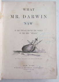
1880 WHAT MR. DARWIN SAW IN SHIP BEAGLE ANTIQUE DURING HIS WORLD TOURNY Elizabeth 4.3(85)See Sold PriceMar 03, 2024