Sold2 Maps of US - 18th century1st item: AMERIQUE SEPTENTRION LE DIVISEE EN SES PRINCIPAUX ETATS; A PARIS CHEZ DELAMARCHE GEO. 1783. French engraved and handcolored map of North America, with major American cities noted. 7 3/4" x 1See Sold Price
Seutter: Antique Map Balkans, Hungary to Greece, 1740Title/Content of Map: Balkan's from Hungary to Greece Date Printed: c1740 Cartographer: Matthaus Seutter Material/Medium: Paper Size: 23 1/2" x 19 3/4" Original hand colored copperplate engraved. PublSee Sold Price
Seutter: Antique Map of Spain and Portugal, 1740Title/Content of Map: Spain and Portugal Date Printed: c1740 Cartographer: Matthaus Seutter Material/Medium: Paper Size: 23 1/2" x 19 3/4" Original hand colored copperplate engraved. Published in AugsSee Sold Price
SoldHomann Heirs: Antique Map of Europe, 1746Map: Europe ** Nuremberg?? Date Printed: 1746 Cartographer: Homann Heirs Material/Medium: Paper Size: 21" x 23 1/4" Nuremberg. Hand colored copperplate engraved. Beautiful baroque style cartouche. PleSee Sold Price
SoldSeutter: Antique Map of France, 1740Title/Content of Map: France by Seutter Date Printed: c1740 Cartographer: Matthaus Seutter Material/Medium: Paper Size: 23 3/4" x 19 3/4" Original hand colored copperplate engraved. Published in AugsbSee Sold Price
SoldZatta: Antique Map of Ancient Greece, 1783Title/Content of Map: Ancient Greece by Zatta Date Printed: 1783 Cartographer: Antonio Zatta Material/Medium: Paper Size: 15 3/4" x 19" Hand colored. Copperplate engraved. Published in Venice. AntonioSee Sold Price
Seutter: Antique Map of Northwest Russia, 1740Title/Content of Map: Northwest Russia Moscowic Kingdom Date Printed: c1740 Cartographer: Matthaus Seutter Material/Medium: Paper Size: 19 3/4" x 23 3/4" Original hand colored copperplate engraved. PuSee Sold Price
Essex Antique County Map By Thomas Moule, C 1840Essex Antique Hand-coloured County Map By Thomas Moule, C 1840. Size: Approx 12.0 x 17.0cm, 4.75 x 6.75 inches. Antique engraved map. Hand colour Please note that this lot has a confidential reserve.See Sold Price
SoldAntique Art Deco 18k Gold European Diamond Engraved Enamel Masonic Dinner RingAn antique solid 18k white gold enamel masonic dinner ring, with 1 old european cut natural diamond (F - VS1; 0.35ct). The ring is size 4.5, weighs a total of 4.17 grams, and measures 20.3mm wide.See Sold Price
Blaeu: Antique Map of Europe, 1650Title/Content of Map: Europe by Blaeu Date Printed: c1650 Cartographer: W. Blaeu Material/Medium: Paper Size: 19" x 24" Hand colored engraved Map. French text on verso. Magnificent example of Dutch goSee Sold Price
SoldOrtelius: Antique Map of Corsica, Tuscany, 1574Map: Senensis Ditionis Accurata Descrip. [etc.] Cartographer: Abraham Ortelius Printing Date: 1574 Medium: Copperplate engraved map. Size: 16 x 21.5 Publisher: Antwerp: Ant Coppenius Diesth Series: ThSee Sold Price
SoldTallis / Rapkin: Antique Map, Plan of Brighton, 1850Title/Content of Map: 'Brighton' Decorative antique town plan Date Printed: c1850 Image Size: Approx 36.5 x 26.5cm, 14.5 x 10.25 inches (Large) Type: Antique engraved map Condition: Good; suitable forSee Sold Price
SoldOrtelius: Antique Map of Lake Como, 1574Map: Larii lacus vulgo comensis descriptio, auct. Pavio Jovio. Cartographer: Abraham Ortelius Printing Date: 1574 Medium: Copperplate engraved map. Size: 16 x 21.5 Publisher: Antwerp: Ant Coppenius DiSee Sold Price
SoldMortier: Antique Map of Ancient Thessaly, 1705Title/Content of Map: Northern Greece Ancient Thessaly, Macedonia & land of Achilles by Mortier Date Printed: 1705-06 Cartographer: Pierre Mortier Material/Medium: Paper Size: 18" x 23 3/4" Antique MaSee Sold Price
SoldSDUK: Antique Map of Portugal, 1845TITLE/CONTENT OF MAP: 'PORTUGAL' Provinces. Algarve Alentejo Estremadura Beira etc. DATE PRINTED: 1845 IMAGE SIZE: Approx 37.5 x 27.5cm, 14.75 x 10.75 inches (Large) TYPE: Antique steel engraved map wSee Sold Price
SoldSDUK: Antique City Map Plan of Amsterdam, 1847Title/Content of Map: 'AMSTERDAM.; inset environs of Amsterdam' Date Printed: 1847 Image Size: Approx 34.5 x 40.5cm, 13.5 x 15.75 inches (Large) Type: Antique steel engraved map with original outlineSee Sold Price
Sold4 Antique English Silver Engraved SpoonsSN with English hallmarks stamped on back. Engraving of wolf or boar on handle. Measurements: Length - 5 1/2 in. Weight - 2.6 ozt.See Sold Price
SoldAnon C1700 Antique Map. The Battle of CannaeCopper Engraved Map Published C1700, London? Unknown Engraver and Artist. Paper Size: 8 x 4.5 inch (20 x 14.5cm) Very minor text offsetting in margins. Good ConditionSee Sold Price
Tallis / Rapkin: Antique Map of of Brighton, 1850Title/Content of Map: 'Brighton' Decorative antique town plan Date Printed: c1850 Image Size: Approx 36.5 x 26.5cm, 14.5 x 10.25 inches (Large) Type: Antique engraved map Condition: Good; suitable forSee Sold Price
Tanner: Antique Map of Balkans with Greece, 1843Title/Content of Map: Balkans with Greece by Tanner Date Printed: 1843 Cartographer: H.C. Tanner Material/Medium: Paper Size: 17" x 14" Hand colored engraved Map based on the work of H.C. Tanner fromSee Sold Price
SoldCornwell & Dower 1849 Lot of 6 European MapsIncl Germany, Austria, Europe, Spain/Portugal, Prussia, and France. Steel Engraved Maps Published 1849, London for "A School Atlas" by James Cornwell. Maps by John Dower. Paper Size: 6.5 x 4 inch (16See Sold Price
Perrot: Antique Rare Map of Corsica, 1823Title/Content of Map: 'Corse' Corsica département. Scarce antique map/carte Date Printed: 1823 Image Size: Approx 13.5 x 8.5cm, 5.25 x 3.25 inches (Small) Type: Antique engraved map with original outSee Sold Price
SoldSDUK: Antique Map, City Plan of Athens, 1847Title/Content of Map: 'ATHENS.; inset Acropolis' Antique town city map plan Date Printed: 1847 Image Size: Approx 35.5 x 41.0cm, 14 x 16 inches (Large) Type: Antique steel engraved map with original oSee Sold Price
SoldMitchell: Antique Map of Ontario in Counties, 1869Map: Ontario in counties Date Printed: 1869 Cartographer: Augustus S. Mitchell Material/Medium: Paper Size: 15 1/4" x 12 1/4" Hand colored engraved map. Printed in Philadelphia. From his 'Mitchell's NSee Sold Price
ANTIQUE SCOTTISH PETRA ENGRAVING BY DAVID ROBERTSAntique Arena Inc.4.5(852)See Sold PriceFeb 24, 2024
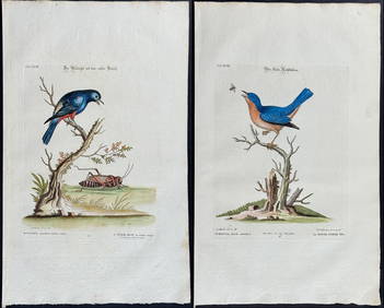
Edwards & Seligmann - 4 Bird EngravingsTrillium Antique Prints & Rare Books4.5(30)See Sold PriceFeb 24, 2024
Map: An 18thC engraved and hand coloured map of Buckinghamshire after Robert Morden. Approx. 8 1/4"Claydon Auctioneers Ltd4.3(125)See Sold PriceFeb 26, 2024
Map: A 19thC engraved and hand coloured map of South America. Published by the Society for theClaydon Auctioneers Ltd4.3(125)See Sold PriceFeb 26, 2024
Map: A 19thC engraved and hand coloured map of St. Petersburg / Sanktpeterburga by W. B. Clarke.Claydon Auctioneers Ltd4.3(125)See Sold PriceFeb 26, 2024
Map: An engraved and hand coloured map titled The Countie of Nottingham described The Shire TownesClaydon Auctioneers Ltd4.3(125)See Sold PriceFeb 26, 2024
Map: A 17thC engraved map of the British Isles titled A Generall Mapp of the Isles of GreatClaydon Auctioneers Ltd4.3(125)See Sold PriceFeb 26, 2024
Map: A 17thC engraved and hand coloured map of Bedfordshire after Robert Morden. Approx. 12 1/2" xClaydon Auctioneers Ltd4.3(125)See Sold PriceFeb 26, 2024
Map: An 18thC engraved and hand coloured map of North America and South America, titled DeClaydon Auctioneers Ltd4.3(125)See Sold PriceFeb 26, 2024
Map: A 19thC engraved and hand coloured map of Buckingham titled A New Map of BuckinghamshireClaydon Auctioneers Ltd4.3(125)See Sold PriceFeb 26, 2024
Map: An 18thC engraved map titled A New and Improved Map of Oxfordshire.. after Thomas Kitchin.Claydon Auctioneers Ltd4.3(125)See Sold PriceFeb 26, 2024
Map: A 19thC engraved map of West Riding, titled A Map of the North Part of the West Riding ofClaydon Auctioneers Ltd4.3(125)See Sold PriceFeb 26, 2024
1738 BIBLE in DUTCH ILLUSTRATED w/ MAPS MASSIVE FOLIO in DUTCH antique BIBLIAJasper524.5(9.8k)See Sold PriceFeb 27, 2024
1711 GREEK BIBLE ILLUSTRATED w/ MAPS VELLUM BOUND antique NEW TESTAMENTJasper524.5(9.8k)See Sold PriceFeb 27, 2024
1675 Horae Hebraicae et Talmudicae by John Lightfoot antique JUDAICAJasper524.5(9.8k)See Sold PriceFeb 27, 2024
1704 DESCRIPTION OF ALL THE SEATS OF THE PRESENT WARS OF EUROPE antique w/ MAPSJasper524.5(9.8k)See Sold PriceFeb 27, 2024
1709 GREEK BIBLE ILLUSTRATED w/ MAPS antique VELLUM BOUND Septuagint editionJasper524.5(9.8k)See Sold PriceFeb 27, 2024
Set of 4 Maps - Netherlands - Seven United Provinces - Germany - Sweden, Denmark, Norway, FinlandProverde Auctions4.3(3)See Sold PriceFeb 28, 2024
Antique Art Deco 20K Gold 1.54 ctw Old European Diamond Long Engraved Dinner RinFederal Assets Auctioneers4.4(411)See Sold PriceFeb 25, 2024
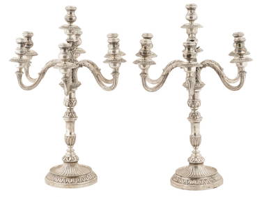
MONUMENTAL ANTIQUE ITALIAN SILVER CANDELABRAS PAIRAntique Arena Inc.4.5(852)See Sold PriceJun 15, 2024
ITALIAN RENAISSANCE MANNER GILT BRONZE ALADDIN LAMPAntique Arena Inc.4.5(852)See Sold PriceJun 15, 2024