Sold3 pieces. Engraved Maps - Egypte: Vaugondy, Rober3 pieces. Engraved Maps - Egypte: Vaugondy, Robert de. Carte de l'Egypte Ancienn et Moderne." (Paris), 1753. 26 x 1/4 x 19 3/8 inches (667 x 492 mm), margins. Repair to verso fold., discoloration on rSee Sold Price
Sold3 pieces. Engraved Maps - Egypt: Mentelle, Edme;3 pieces. Engraved Maps - Egypt: Mentelle, Edme; Chanlaire, Pierre Gregoire. Carte Physique et Politique de l'Egypte." [Paris], An VII [1797]. 19 x 24 1/4 inches (482 x 615 mm), trimmed within bottomSee Sold Price
Sold1 piece. Hand-Colored Engraved Map. Laurie, Rober1 piece. Hand-Colored Engraved Map. Laurie, Robert; Whittle, James. A New Map of The Middle & Upper Parts of Italy,... Tuscany;... Lombardy,... Parma,... Venice..." London, 1799. 27 1/4 x 19 3/4 incheSee Sold Price
Sold1 piece. Hand-Colored Engraved Map. Morden, Rober1 piece. Hand-Colored Engraved Map. Morden, Robert. Hamp Shire." [London], [1722]. 14 3/8 x 16 3/4inches; 365 x 425 mm, narrow margins. Old (orig.?) color. Generally clean & bright."See Sold Price
Sold1 piece. Hand-Colored Engraved Map. Elwe, Jan B.1 piece. Hand-Colored Engraved Map. Elwe, Jan B. Carte de l'Egypte, de la Nubie, de l'Abissine." Amsterdam, 1792. 19 3/8 x 22 3/8 inches (492 x 568 mm), margins. Minor smudging to margins. Orig. colorSee Sold Price
Sold1 piece. Engraved Hand-Tinted Map. Buache, Philip1 piece. Engraved Hand-Tinted Map. Buache, Philippe. Carte Mineralogique, sur la Nature du Terrein... l'Egypte,... Palestine... Syrie." [Paris]: Mem. de l'Acade, 1751. 11 1/4 x 14 3/4 inches; 285 x 37See Sold Price
Sold3 pieces. Engraved Maps & Plans - Egypt: [Mercato3 pieces. Engraved Maps & Plans - Egypt: [Mercator/Hondius/Jansson Atlas?] Africae, Egyptum Inferiorem Exhibens." Ca. 1730. Partly hand-colored engraving. 9 3/4 x 14 1/2 inches (247 x 368 mm), wide maSee Sold Price
Sold3 pieces. Engraved Maps with Outline Color. Sanso3 pieces. Engraved Maps with Outline Color. Sanson d'Abbeville, Nicolas. [France & Flanders]: La Flandre Francoise." Paris: A.H. Jaillot, 1674. * "Le Brabant Espagnol... De Brusselles, de Louvain..."See Sold Price
Sold3 pieces. Hand-Colored Engraved Maps - America: J3 pieces. Hand-Colored Engraved Maps - America: Janvier, Robert. L'Amerique Divisee par Grandes Etats." Paris, 1783. 12 3/8 x 17 7/8 inches; 314 x 454 mm, full margins. Light to moderate foxing. Orig.See Sold Price
Sold3 pieces. Hand-Colored Engraved Maps. [Europe]: H3 pieces. Hand-Colored Engraved Maps. [Europe]: Homann, John Baptist. Potentissimae Helvetiorum Republicae Cantones Tredecim." Nuremberg, [ca. 1730]. 19 x 22 inches; 482 x 558 mm. Some creasing, smallSee Sold Price
Sold1 piece. Hand-Colored Engraved Map. Laurie, Rober1 piece. Hand-Colored Engraved Map. Laurie, Robert; Whittle, James. A New Map of The Whole Continent of America; Divided into North and South and West Indies, wherein are exactly The United States ofSee Sold Price
Santini (P.) North AmericaSantini (P.) L'Empire de la Chine; L'Empire du Japon; Archipel des Indes Orientales,3 maps of the Far East and South East Asia, the first after Bonne, the other two after Vaugondy, 3 engravedSee Sold Price
Sold1 piece. Engraved Map with Outline Color. Robert1 piece. Engraved Map with Outline Color. Robert de Vaugondy, Gilles & Didier. Etats-Unis de l'Amerique Septentrionale..." Paris: Boudet, 1785 (or later). 19 1/2 x 25 1/2 inches; 495 x 647 mm, full? mSee Sold Price
Sold[MISCELLANY]. 3 Engraved Maps. ++ America. Dr[MISCELLANY]. 3 Engraved Maps. ++ America. Drawn and engraved by J. Dower, Lon: Henry Teasdale, 1831. 16 1/8 x 13 1/4. Handcolored. Lightly soiled and toned. ++ Sr. Robert [de Vaugondy]. Cercle De FraSee Sold Price
Sold9 pieces. Engraved Maps - Small Formats - Egypt9 pieces. Engraved Maps - Small Formats - Egypt: Munster, Seb. La Description d'Egypte..." Ca. 1540. Woodcut. 4to tear sheet. * Gastaldi, pub. "Tabula Africae." Ca. 1548. Woodcut. 12mo double-page. *See Sold Price
Sold9 pieces. Engraved Maps - Egypt - French, British9 pieces. Engraved Maps - Egypt - French, British & American printings, ca. 1800-1830: Cook, John, pub. Plan du Kaie et de Environs." London, ca. 1802. Engraving. 10 1/2 x 14 3/8 inches (266 x 365 mm)See Sold Price
Sold2 pieces. Engraved Maps with Outline Color. Sanso2 pieces. Engraved Maps with Outline Color. Sanson, d'Abbeville, Nicolas. [Central Europe]: Partie du Cercle d'Austriche." Paris: A.H. Jaillot, 1681. Double sheet, 22 3/4 x 34 3/4 inches; 578 x 882 mmSee Sold Price
Sold1 piece. Engraved Map with Outline Color. Senex,1 piece. Engraved Map with Outline Color. Senex, John. A Map of Louisiana and of The River Mississippi." [London], [1719 or later.] 19 1/8 x 22 3/8 inches; 485 x 568 mm, margins. Slightly toned, someSee Sold Price
Sold1 piece. Engraved Map. Ortelius, Abraham. Palesti1 piece. Engraved Map. Ortelius, Abraham. Palestinae sive Totius Terrae Promissionis Nova Descriptio Auctore Tilemanno Stella Sigenens." [Amsterdam], [ca. 1570-1575]. 13 7/8 x 18 3/4 inches (352 x 476See Sold Price
Sold1 piece. Engraved Map with Outline Color. Moll, H1 piece. Engraved Map with Outline Color. Moll, H. Carolina." (London), 1729. 7 3/4 x 10 3/4 inches; 197 x 273 mm - image size. Central & western parts of map dampstained. Framed."See Sold Price
Sold1 piece. Engraved Map with Outline Color. Fer, Ni1 piece. Engraved Map with Outline Color. Fer, Nicolas de. Le Cours du Nil, Suivant les Auteurs Modernes..." Paris, 1720. 18 1/4 x 25 3/4 inches (463 x 654 mm), full margins. Slightly toned. Orig. colSee Sold Price
Sold1 piece. Engraved Map with Outline Color. Kitchen1 piece. Engraved Map with Outline Color. Kitchen, Thomas. A New and Accurate Map of The British Dominions in America, According to the Treaty of 1763." [London], [ca. 1766]. 21 3/8 x 25 inches; 542 xSee Sold Price
Sold1 piece. Engraved Map with Out-Line Color. Nolin,1 piece. Engraved Map with Out-Line Color. Nolin, Jean Baptiste (son). Le Comte et Gouvernement de Provence." Paris, 1742. 18 x 24 3/8 inches; 457 x 619 mm, margins. Moderately browned, scattered foxiSee Sold Price
SoldJigsaw Maps.- Atlas DelamarcheJigsaw Maps.- Atlas Delamarche8 engraved maps with original hand-colouring, mounted on wood and dissected as jigsaw puzzles, each 235 x 470mm., 4 minor losses to 3 pieces from Europe, one fromSee Sold Price
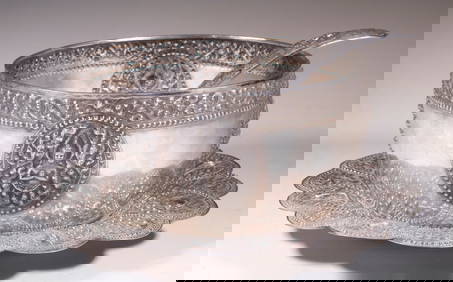
SOUTHEAST ASIAN SILVER PUNCH BOWL, TRAY & LADLEThomaston Place Auction Galleries4.4(386)See Sold PriceFeb 24, 2024
3 Pieces by Judith Leiber, Swarovski crystal floral clutch and accessories, can be worn as shoulderNeely Auction4.6(224)See Sold PriceFeb 25, 2024
3 Piece sterling silver picture frames, (1) Cartier frame, engraved Cartier label on top, measuresNeely Auction4.6(224)See Sold PriceFeb 25, 2024
Gorham Plain Engraved by Gorham Sterling Silver Steak Carving Set 3pc HHWSMynt Auctions4.6(680)See Sold PriceFeb 25, 2024
17th Century Hand Colored Engraved Map of GermanyGlobal Auctions Company4.3(36)See Sold PriceMar 03, 2024
18th Century Hess Germany Hand colored Engraved MapGlobal Auctions Company4.3(36)See Sold PriceMar 03, 2024
Hand Colored Engraved Map of Europe, Jean Baptiste Bourguignon Anville 1754Global Auctions Company4.3(36)See Sold PriceMar 03, 2024
Map: A 17thC engraved map of the British Isles titled A Generall Mapp of the Isles of GreatClaydon Auctioneers Ltd4.3(125)See Sold PriceFeb 26, 2024
Map: An 18thC engraved map titled A New and Improved Map of Oxfordshire.. after Thomas Kitchin.Claydon Auctioneers Ltd4.3(125)See Sold PriceFeb 26, 2024
1738 BIBLE in DUTCH ILLUSTRATED w/ MAPS MASSIVE FOLIO in DUTCH antique BIBLIAJasper524.5(9.8k)See Sold PriceFeb 27, 2024
1675 ELZEVIER JULIUS CAESAR antique ILLUSTRATED w/ MAPS ROMAN HISTORYJasper524.5(9.8k)See Sold PriceFeb 27, 2024
Ireland.- Smedley (Edward) Erin. A Georgraphical and Descriptive Poem, 2 parts in 1, first edition,Forum Auctions4.3(52)See Sold PriceFeb 29, 2024
Gorham Plain Engraved C by Gorham Sterling Silver Steak Carving Set 3pc 9 3/4"Mynt Auctions4.6(680)See Sold PriceMar 01, 2024
Gorham Plain Engraved by Gorham Sterling Silver Steak Carving Set 3pc HHWSBidhaus4.3(747)See Sold PriceMar 04, 2024
ANCIENT NORTH AFRICA. Greek colonies. "La Libye, L'Egypte…". TARDIEU 1830 mapJasper524.5(9.8k)See Sold PriceFeb 28, 2024
Set of 3 Maps - Netherlands - Belgien - Switzerland - J. BarlowProverde Auctions4.3(3)See Sold PriceFeb 28, 2024
Herman Moll A New Map of Ye North Parts of AmericaWillow Auction House4.5(283)See Sold PriceMar 14, 2024


![[MISCELLANY]. 3 Engraved Maps. ++ America. Dr (1 of 3)](https://p1.liveauctioneers.com/179/10971/2682749_1_x.jpg?height=282&quality=70&version=1162265652)