Sold3 MAPS- REPORT ON THE PROJECT OF UNITING THE GREAT BAYS3 MAPS- REPORT ON THE PROJECT OF UNITING THE GREAT BAYS OF LONG-ISLAND BY CANALS WITH LARGE FOLDING MAP, 1848; HYDE'S POCKET MAP OF THE BOROUGHS OF MANHATTAN AND THE BRONX NEW YORK CITY, 1905; AND EARSee Sold Price
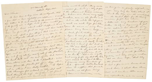
SoldCanals on Long IslandHeading: (New York - Long Island) Author: Title: Report on the project of uniting the great bays of Long-Island by canals, from Coney-Island to Bridgehampton Place Published: Brooklyn, NY Publisher:ESee Sold Price
de Ferrer: Antique Map of Moore's Pen, Jamaica, 1818Map: Moore's Pen, Jamaica, 1818 Date Printed: 1818 Cartographer: José Joaquín de Ferrer Size: 11 3/4" x 15" Map features Great Goat Island, Ridley's Bay, Coleman's Bay, Salt River Bay, Peake Bay, MaSee Sold Price
SoldNY Times Civil War June, July Sept 1861, The GreatLot of 3. NY Times paper's hardcovers with gold lettering and plastic overlay[x=#8217/]s. Articles : Rebels believed 10,000 strong w/map of Fort Pickens. On the ground report from Fort Pickens. PossibSee Sold Price
Sold3 BOOKS- REPORT OF THE BOARD OF GENERAL MANAGERS OF3 BOOKS- REPORT OF THE BOARD OF GENERAL MANAGERS OF THE EXHIBITION OF THE STATE OF NEW YORK AT THE WORLD'S COLUMBIAN EXPOSITION, 1894, WITH GREAT PLATES AND MAP OF NEW YORK STATE; JOURNALS OF THE MILISee Sold Price
SoldMap of Ipswich Bay, EtchingMap of Ipswich Bay, etching, with embossed "Massachusetts Historical Society" mark; 31 3/4" h x 23" w (view), 39" h x 30" w (frame). The absence of a condition report is not an implication that the loSee Sold Price
SoldVINTAGE HAZEL ATLAS ROOSTER 6 GLASS TUMBLER JUICE SETCups measure 8 1/8" tall by almost 3" across top. depiction of a rooster in yell and brown. great condition with minor flaws to design on glasses. all stamped HA for Hazel Atlas. the set is alSee Sold Price
Set of (3) Maps of Great Smokey Mountains 1960's & 70'sThis lot includes: (3) Great Smokey Mountains Set of Maps Condition is used and refer to photographs for additional details. The maps date to 1949 and have been in a binder for years. They have some eSee Sold Price
MAPS IN BOOK, Northern South America, HerndonNorthern South America. Lt. William Lewis Herndon, [3 Maps] Maps - Herndon's Report, 1853 (published). Printed Color. In 1851, Lieutenant Herndon was commissioned to lead the first American expeditionSee Sold Price
Sold3 . WATERPROOF MARINE MAPs TAMPA BAY SOUTHERN PART3 WATERPROOF MARINE MAPs TAMPA BAY SOUTHERN PART.This is a total of THREE marine maps, waterproof, and two of the maps are reversible. One map is of our Tampa Bay area. Anna Maria Sound and Sarasota BSee Sold Price
SoldAtlases.- Russell (John) and others. A Complete AtlasAtlases.- Russell (John) and others. A Complete Atlas of the World, Printed at the Caxton Press, engraved hand-colour frontispiece and 33 maps (3 folding), folding map of Great Britain with tears alonSee Sold Price
SoldMAPS, ETC.Six framed items including 3 maps, one of Chesapeake Bay; Etching of Cintra, notice of a Cintra inspired home; Along with a Center Bridge Inn invitation; Largest: 22" x 16" (sight)See Sold Price
SoldMap of the Yukon Territory...Reserve Reduced! Title: Map of the Yukon Territory... Publication Date: 1905 Cartographer: KEELE, J. Publisher: GEOLOGICAL SURVEY OF CANADA Size (inches): H24.5 - W14.3 Map showing from "Yukatat Bay"See Sold Price
SoldLionel FARR Series 3 6438 9772 19205 MINTLionel Famous American Railroad Series no. 3 6438 Great Northern illuminated bay window caboose in OB. Also included is a 9772 Great Northern boxcar in incorrect box and a 19205 Great Northern boxcarSee Sold Price
Sold3 Maps incl: Plan de la Bay et Rade... 1781.[Bermuda/Nautical Maps]. 3 Engraved Maps. ++ Plan de la Baye et Rade du Cap Francais… Shows soundings. Inset: “S. Domingue.” De Foligne, 1781. 14 7/8” x 15 ¾”. Mat burn. Tape to edges of veSee Sold Price
SoldRare 1938 Inyo County Mines Report With Great MapThis is the holy grail of information about Inyo County mines. Rare and highly sought after, this is the October, 1938, Volume 34, #4, California Journal of Mines and Geology, State Mineralogist's RepSee Sold Price
SoldPetroliana service station maps display cabinetBeautiful metal countertop maps display cabinet loaded with vintage road maps. Several of the maps are from the 1930's. The map display has a glass front with 3 shelves for displaying maps. A great seSee Sold Price
SoldLionel 6-17174 Great Northern Standard HopperThis is a Great Northern 3-Bay Hopper from 2002. This hopper features die-cast metal sprung trucks, die-cast metal operating knuckle couplers, and metal wheels and axles. Includes original box. - - -See Sold Price
SoldEPHEMERA, noted advertising labels (8) includingEPHEMERA, noted advertising labels (8) including "Hambone Sweets"; 1911 plan of Jervis Bay; NSW Govt Reports (3) including 1861 "Field of Mars Common"; 1936 sheet music "WaltzSee Sold Price
SoldPORSCHE, mixed lot of 3 pieces No. 1: press report 1980PORSCHE, mixed lot of 3 pieces No. 1: press report 1980, project Le Mans, racing version 924 Carrera GT, inclusive 7 B/W photos. No. 2: press report March 1990 Porsche programme, complete, inclusive BSee Sold Price
SoldRailroad Annual Passes (5): CJ&M, C&WM, DBC&A, GRAll of these passes were issued in 1894: (1) Cincinnati Jackson & Mackinaw (2) Chicago & West Michigan / Detroit Lansing & Northern – unusual map design (3) Detroit Bay City & Alpena – in receiverSee Sold Price
[Senex (J)] A Chart of the Coast of Cormandel[Senex (John)] A Chart of the Coast of Cormandel and the great Bay of Bengal, engraved map of the Bay of Bengal, with outline hand-colouring, 485 x 575mm., browning to vertical fold, tears anSee Sold Price
Sold1853 Maps to Andrews Report (3)Three large Israel D. Andrews 1953 Maps. Some tape repair and previous owner stamp on verso. All attached to folio which measures 9.375 in. x 6.125 in. Contains: Map 1: Railroad Map of the United StatSee Sold Price
SoldMcNally: Map of the United States, 1887Map: 1887 Rand McNally US Map -- Map of the United States Cartographer: Rand McNally Year/Place: 1887, Chicago Dimensions: 14.5 x 27.3 in. A very nice US map, showing great deal of topographical and sSee Sold Price
Vintage Estate World Maps II Signed & Framed Art PrintMannys Jewelry4.6(335)See Sold PriceMar 03, 2024
LARGE LATE 17TH C. DUTCH CHART OF CANADA, GREAT LAKES, NEW FRANCE, LABRADOR, HUDSON BAY, BY PIERREThomaston Place Auction Galleries4.4(393)See Sold PriceFeb 24, 2024
(3 Ohio Pennants Great Lakes Expo, Put in Bay, '56 Blue holeDana J. Tharp Auctions4.7(271)See Sold PriceFeb 24, 2024
D'Entrecasteaux - Australia: Coasts of Van Diemen's Land (New Holland). 9Trillium Antique Prints & Rare Books4.5(32)See Sold PriceFeb 24, 2024
D'Entrecasteaux - Tasmania, Australia: Map of the Northern Portion of Recherche Bay. 5Trillium Antique Prints & Rare Books4.5(32)See Sold PriceFeb 24, 2024
D'Entrecasteaux - Australia: Chart of Van Diemen's Land (New Holland). 3Trillium Antique Prints & Rare Books4.5(32)See Sold PriceFeb 24, 2024
D'Entrecasteaux - Map of Australia (New Holland), New Zealand, and southern Asia and surroundingTrillium Antique Prints & Rare Books4.5(32)See Sold PriceFeb 24, 2024
Donovan's The Natural History of British Shells - 5 Volumes in 3 Books with 180 EngravingsTrillium Antique Prints & Rare Books4.5(32)See Sold PriceFeb 24, 2024
Vintage GRAFF Ruby Diamond 18k Yellow Gold RING 2.06 cts AGL Report Size 6.25Jasper524.5(9.9k)See Sold PriceFeb 27, 2024
Victorian Natural Pearl Diamond TIE PIN in Silver and 14k Yellow Gold GIA ReportJasper524.5(9.9k)See Sold PriceFeb 27, 2024
Crown Great Western Mfg. Bicycle Head BadgeGrant Zahajko Auctions, LLC4.7(1k)See Sold PriceMar 06, 2024


![[Senex (J)] A Chart of the Coast of Cormandel (1 of 1)](https://p1.liveauctioneers.com/410/3027/1300251_1_x.jpg?height=282&quality=70)