Sold3 maps incl 2 sheets of Corso Del Po... 1703.[De Rossi/Italy] 3 Maps. ++ Corso Del Po Per La Lombardia Dalle Sue Fonti Sino Al Mare… 2 sheets of a 3-sheet map (eastern and western). By Agostino Sargente, revised by Domenico de Rossi. Rome: 170See Sold Price
SoldDe L'Isle Engraved Map of CanadaCarte du Canada ou de la Nouvelle France. Guillaume De L’isle (1675-1726). Engraved Map. Paris, Quai de LÂ’Horloge, 1703. 20 x 26 3/4 inches sheet, 31 1/2 x 38 1/2 inches framed. "Del'Isle's mapSee Sold Price
Coronelli Map of the Amazon RiverCoronelli, Vencenzo (1650-1718). Corso del Fiume dell Amazoni. Engraved map. Venice, c. 1691. 14 1/4” x 19 1/2” sheet. This uncommon map of the northern half of the continent focuses on the courseSee Sold Price
Sold2 maps incl Austrian map of New World [c1763-1770[Americas]. 3 engraved maps, outline color. ++ Uibersichts Karte Von America. 2 sheets, for North American, and South America, c.1763-1770. Engraved in lower margin of each map, ''S. V. Adm- 15 Kr. W.See Sold Price
SoldForlani's Great Map of GermanyFORLANI, Paolo (fl. 1560-1571) - GASTALDI, Giacomo (c. 1500-1566).[Northern Europe] Germania del Gastaldo.Engraved map.Venice: Paulo Forlani, Veronese, 156420 1/2" x 28 1/4" sheet; 32" x 39 3/4" frameSee Sold Price
Forlani Map of Germany, 1564FORLANI, Paolo (fl. 1560-1571) - GASTALDI, Giacomo (c. 1500-1566). [Northern Europe] Germania del Gastaldo. Engraved map. Venice: Paulo Forlani, Veronese, 1564. 20 1/2" x 28 1/4" sheet; 32" x 39 3/4"See Sold Price
De L'Isle Carte du MexiqueDe L'isle, Guillaume (1675-1726). Carte du Mexique et de la Floride... Engraved map with orginal hand color in outline. Paris: De L'isle, Quai de l'Horlage, 1703. 21 1/2" x 29 3/4" sheet.See Sold Price
A Seminal map of Canada, which first appeared in 1703Carte du Canada ou de la Nouvelle France... Guillaume Del'Isle. Engraved map. Paris: Chez L'Auteur, 1703. 20 1/4 x 26 1/4 inches visible, 30 1/2 x 36 3/4 inches framed. One of the seminal maps of CanaSee Sold Price
SoldJacques Nicolas Bellin (French, 1703-1772)Jacques Nicolas Bellin (French, 1703-1772), "Plan de la Nouvelle Orleans", [1764, Paris], copper-engraved map with hand-coloring in outline, sheet 12 3/8 in. x 14 1/2 in., attractively matted and framSee Sold Price
Sold3 Maps, incl 2 editions of: Linguistic Stocks...[Native American Languages/New Mexico]. 3 Maps. ++ J. W. Powell. Linguistic Stocks of American Indians North of Mexico by J. W. Powell. Area of coverage extends from Greenland to the northern coast ofSee Sold Price
Sold3 maps incl 2 1826 maps by L. Rossini.3 maps. The first 2 listed below are by L. Rossini and from: Le Antichità De’ Contorni Di Roma, 1826. Includes: Illa Adriana por tuto il vasto Impero Romano..., 1826. Image: 14 1/4" x 27 3/4See Sold Price
Sold3 Southern Maps, incl. 2 Antonio Zatta 1778, SC 1796Three (3) Southern Maps, including two (2) Antonio Zatta 1778, one (1) South Carolina 1796. 1st-2nd items: Two (2) Antonio Zatta (Italian, fl. 1757-1797) maps of Virginia, Maryland, and the Carolinas,See Sold Price
SoldTANNER, HENRY SCHENCK. A Description of the CaTANNER, HENRY SCHENCK. A Description of the Canals and Rail Roads of the United States. 3 engraved maps, 2 sheets of profiles. Tall 8vo, publisher's cloth, neatly rebacked with most of the original baSee Sold Price
SoldJean Baptiste Bourguignon d'Anville (French)Jean Baptiste Bourguignon d'Anville (French, 1697-1782), "Premiere Partie de la Carte d'Asie...", "Seconde Partie de la Carte d'Asie..." and "Troisieme Partie...", 3 maps, each with 2 sheets, hand-colSee Sold Price
SoldJean Baptiste Bourguignon d'Anville (French)Jean Baptiste Bourguignon d'Anville (French, 1697-1782), "Premiere Partie de la Carte d'Asie...", "Seconde Partie de la Carte d'Asie..." and "Troisieme Partie...", 3 maps, each with 2 sheets, hand-colSee Sold Price
SoldSenex (John) Denmark; Sweden; GermanySenex (John) Denmark; Sweden; Germany, together 3 engraved maps, each 2 sheets joined, with original hand-colouring, large decorative cartouches, Denmark (uncoloured), 665 x 970mm., some brownSee Sold Price
3 Maps incl: Le Cours Du Po... Covens and Mortier[Italy/Middle East] 3 Maps. ++ Le Cours Du Po Dans Le Piemont… Shows rivers of the Po River Valley in Italy. Amst: Jean Covens and Corneille Mortier, (nd). From an edition of “Atlas Nouveau, ConteSee Sold Price
[MAPS]. Group of 3, incl. 2 maps of the coast of Guinea & one of the empire of Alexander the Great. [MAPS]. Group of 3, incl. 2 maps of the coast of Guinea & one of the empire of Alexander the Great. D'ANVILLE, Jean Baptiste Bourguignon and F. A. SCHRAEMBL. Guinea Zwischen Sierra-Leona undSee Sold Price
Sold1745 Guillaume De L'Isle Carte Du Canada ou de la1745 Guillaume De L'Isle Carte Du Canada ou de la Nouvelle France first published in 1703- 2 sheet map of French Canada, 20.5” x 26.25”See Sold Price
SoldBAGSHAWE, THOMAS WYATT, Two Men in the Antarctic.BAGSHAWE, THOMAS WYATT, Two Men in the Antarctic. An Expedition to Graham Land 1920-1922. Foreword by Frank Debenham. pp, xxii, 292p, 3 endpaper maps, 2 panoramas on one fldg sheet, 20 plates, 3 textSee Sold Price
Idraulica - Barattieri, Gio. BattistaArchitettura d'Acque divisa in Otto Libri Piacenza, Gio. Bazachi, 1656-1664. In 2°. 2 parti in un vol. 40 xilografie nel testo, di cui 2 su doppia pagina raffiguranti entrambi il corso del Po dal LamSee Sold Price
SoldTHOMSON, JOHN. A New General Atlas.THOMSON, JOHN. A New General Atlas. 77 engraved mapsheets, with 2-sheet and 3-sheet maps counted by sheet. Folio, early 1/2 morocco, quite worn, covers will be loose; considerable browning and offsettSee Sold Price
SoldOttens. Regnum Persicum...in Asia. c.1730.[Middle East] Ottens, Josua. “Regnum Persicum Imperium Turcicum in Asia, Russorum Provinciae ad Maris Caspium.” Amsterdam, c.1730. 2 sheets joined. Engraved map. 33 3/4” x 19 3/8&rdqSee Sold Price
Sold3 Maps incl: D. Carolina nebsteinem... [ca. 1740].[Southeast/Carolinas/FL]. 2 Maps. Matted and framed under glass. Not examined out of frames. ++ D. Carolina nebsteinem Theil von Florida. Shows the Carolinas (including Georgia), with Florida above thSee Sold Price
Rembrandt van Rijn. St. Jerome in a Dark Chamber (1642). New Hollstein 212, III/III Thin, tan laidTremont Auctions4.5(297)See Sold PriceFeb 25, 2024
Rembrandt van Rijn. The Adoration of the Shepherds: A Night Piece (c.1657). New Hollstein 300, IX/XITremont Auctions4.5(297)See Sold PriceFeb 25, 2024
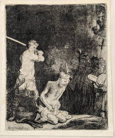
Rembrandt van Rijn. The Beheading of St. John the Baptist (1640). New Hollstein 183, III/III FairlyTremont Auctions4.5(297)See Sold PriceFeb 25, 2024
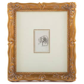
2 architectural drawings. 1) Small round watercolor with classical ruins and figures attributed toTremont Auctions4.5(297)See Sold PriceFeb 25, 2024
Hand Colored Engraved Map of Europe, Jean Baptiste Bourguignon Anville 1754Global Auctions Company4.3(36)See Sold PriceMar 03, 2024
San Xavier Del Bac Mission, Edward S. Curtis photogravurePBA Galleries4.7(385)See Sold PriceMar 07, 2024
Allessandro dalla Via (act. 1688-1724), after Gasparo Vecchia (act. 17th century): Veduta Del TempioSTAIR4.5(291)See Sold PriceMar 06, 2024
Antique Map of France, 1703 by Gillaume Del Isle PrintAntiques Online Auctions4.6(415)See Sold PriceMar 14, 2024
Herman Moll A New Map of Ye North Parts of AmericaWillow Auction House4.5(289)See Sold PriceMar 14, 2024
Antique Pennsylvania Map Fragment incl Wellersburg and New CentervilleCordier Auctions & Appraisals4.4(1.5k)See Sold PriceMar 02, 2024
20 Pcs Vintage Ephemera incl Political Cigar BansCordier Auctions & Appraisals4.4(1.5k)See Sold PriceMar 02, 2024


![[MAPS]. Group of 3, incl. 2 maps of the coast of Guinea & one of the empire of Alexander the Great. (1 of 3)](https://p1.liveauctioneers.com/197/333931/180433602_1_x.jpg?height=282&quality=70&version=1719251536)


![3 Maps incl: D. Carolina nebsteinem... [ca. 1740]. (1 of 3)](https://p1.liveauctioneers.com/179/41615/18011248_1_x.jpg?height=282&quality=70&version=1369948904)