Sold3 Maps: Bethune + ...Citadelle d'Arras + ...Malach[Views] 3 Maps. ++ PLAN DE LA VILLE ET CITADELLE D’ARRAS.... Bird’s-eye map. Below scale: “A Bruxelles. Chez Eugene Henry Fricae rue de la Magdelaine. 1710.” 15 x 19 1/4 in. “No. 68” in maSee Sold Price
SoldA World War 1 Trench Map Arras 51b N.W. 3 Edition 4AA World War 1 Trench Map Arras 51b N.W. 3 Edition 4A Scale 1:10,000 Corrected to October 1916, folded and mounted on cloth with glossary; another map Lens 11, scale 1: 100,000 1915 folded and mountedSee Sold Price
The Battle of Arras - Spring 1917 MapThe Battle of Arras - Spring 1917 World War I One. Linen backed. Map 3 - Ordnance Survey - Large Map with Scale Publisher British Dated: 1919 Type: CSee Sold Price
SoldFrance.- Ortelius (Abraham) Artesia; and 3 other FrenchNO RESERVE France.- Ortelius (Abraham) Artesia; and 3 other French provincial maps, showing northern France, from Calais to Cambrai in the south-east, including Lille, Arras and Kortrijk, engraved mapSee Sold Price
Sold[CITY VIEW/FRANCE]. N[icholas] Cochin. Arras[CITY VIEW/FRANCE]. N[icholas] Cochin. Arras En Artois. Double-page engraved map on laid paper, 17 3/4 x 21 1/2, probably mid-17th century. Bird's eye view fully hand-colored, with soldiers on foot anSee Sold Price
Kershaw County Hand Drawn 1897 Survey Mapdrawn by N.A. Bethune at request of William Johnson. detailing one hundred fifty acres at the head of Boggy Branch Waters. H12 1/2"W8 3/4"See Sold Price
Sold3 Map Prints2 are approx 21" x 23" and other is 21" x 24".Believed to be decorator prints.See Sold Price
SoldGrp: 3 Maps Eastern Europe Ukraine Romania BlaeuGroup of three maps of Eastern Europe. Includes one map of Walachia, Serbia, Bulgaria, and Romania by Willem Janszoon Blaeu (1571-1638); one map of Slovenia, Croatia, and Bosnia by Blaeu after GerarduSee Sold Price
SoldEarly New York, MacCoun, (3) maps, 1909Early New York, MacCoun, (3) maps, 1909, Townsend MacCoun, Early New York. (3) color maps (of 5 called for) in a paper covered linen folder, printed by L. L. Poates, "New Amsterdam 1653-1664" and "NewSee Sold Price
Sold1748 George Anson World Voyage 3 HUGE MAPS Spain South America Sea Navigation1748 George Anson World Voyage 3 HUGE MAPS Spain South America Sea Navigation George Anson was an 18th-century British Navy admiral who is noted for his important world voyage in which he circumnavigaSee Sold Price
Sold(3) EARLY MAPS and a PRINT AFTER WILLIAM BLAKEIncluding: 1886 Fulton's Territory of Alaska, Hawaiian Group or Sandwich Islands, New Zealand, Feejee Islands, 1867 "The World in Two Hemispheres" by Mitchell (colored) and "The Day of Judgement" prinSee Sold Price
Sold3 Vintage maps1, Vintage maps topographical map of North and South Carolina, a large portion of Georgia and part of a joining states XL plate 1966, 2, Village map Panera of the sea of war Birdseye view of North CarSee Sold Price
SoldThe Fighting Cheyennes by George Bird GrinellThe Fighting Cheyennes by George Bird Grinell Dimensions: Size: 6 1/2" - 9 3/4" tall Scribner's, NY, 1915. Cloth. Condition: Good. First Edition. - 431 pages, illustrated with 11 maps, 3 of them foldiSee Sold Price
SoldChart of the World on Mercators ProjectionCirca 1796 Lot of 2 Antique World Maps; Titles: "Chart of the World on Mercators Projection" (Doolittle, sculp.) Approximate size: 11" x 8-3/8". "Map of the World from the best Authorities" (DoolittleSee Sold Price
SoldLot of Walt Disney World Vintage Ephemera. Included areLot of Walt Disney World Vintage Ephemera. Included are 2 1970's WDW Magic Kingdom Maps, 3 Mickey Mouse Weekly's Epcot Brochere, It's a Small World Souviner Guide, Pictoral WDW Guide, Small World RecoSee Sold Price
SoldMortier: Antique Map of Ancient Israel, 1705Title/Content of Map: Ancient Israel King Solomon's Kingdom Date Printed: 1705-06 Cartographer: Pierre Mortier Material/Medium: Paper Size: 23 2/3" x 19 2/3" Antique Map. Copperplate engraved with oriSee Sold Price
SoldOversized Oak Country Store 3-Section Map CaseOversized Oak Country Store 3 Section Map Case Cabinet offers upper with double glass doors opening to pigeon hole storage; middle and lower with narrow map drawers; paneled sides, c1900. Measures - 7See Sold Price
SoldRailroad Annual Passes 5 B&NW, CGW, II&I, IC, WCThis group of passes all date from 1894: (1) Burlington & North Western (2) Chicago Great Western – nice maple leaf logo map (3) Indiana Illinois & Iowa with 3 eyes logo (4) Iowa Central (5) WisconsSee Sold Price
Sold(3) Early Florida Maps, Bloomfield, Colton, 1880sThree early Florida maps including Bloomfield's Illustrated Historical Guide to St. Augustine, along with two copies of G.W. & C.B. Colton's New Sectional Map of the State of Florida. All circa 1880s.See Sold Price
Sold[Map] "Le Siege d'Arras" Paris, 1654"Le Siege d'Arras leve pour la Deffait des Ennemis" with a birds-eye view of the battle and perspective view of the city; designed as a hanging wall map, 87 x 81 in. rebacked with linen. (Known in onlSee Sold Price
SoldEARLY MANUSCRIPT MAPS ACTUAL SURVEYSH/P LOT (3) EARLY MANUSCRIPT MAPS ACTUAL SURVEYS W/ SECTION LOT/PLOT SIGNED SAMUEL PRESTON-WM. SIMPSON, C. 1791, LARGEST 10" X 16"See Sold Price
SoldANTIQUE HAMILTON-ECONOMY 15-DRAWER MAP CABINETANTIQUE HAMILTON-ECONOMY 15-DRAWER MAP CABINET (3) 5-drawer sections sitting on a base; All drawers have 2 copper pulls and copper information holding plates on front; Made of oak, brass "Hamilton EcoSee Sold Price
Sold(3) LARGE DECORATIVE PARIS MAP PRINTSDimensions: (Frame) H 76.25" x W 34" Condition: Light frame wear.See Sold Price
SoldLOT (3) EARLY POCKET BOOK MAPS C.1830'sLOT (3) EARLY POCKET BOOK MAPS INCL. H/C STATE OF NEW YORK BY HUMPHREY PHELPS,1833, 16" X 21", STATE OF NEW JERSEY BY J. LOW, C. 1830, 10 1/2" X 7 1/2", STATE OF PENNSYLVANIA BY A. FINLEY, C. 1830, 9"See Sold Price
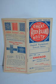
Chicago Rock Island and Pacific RY October 1896 Public TimetableJM Hobby Supply and Railroad Artifact Auctions4.4(126)See Sold PriceFeb 24, 2024
DAVID ROBERTS - Holy Land / Syria / Egypt etc. 3 x Folio Volumes 1849 Very RareLuis Porretta Fine Arts4.3(10)See Sold PriceMar 02, 2024
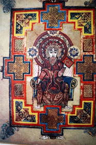
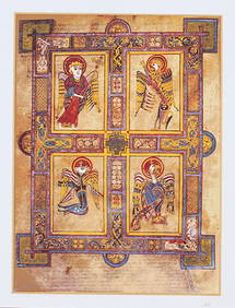
THE BOOK OF KELLS 3 x Limited Edition Serigraph Hand Made Prints Celtic ArtLuis Porretta Fine Arts4.3(10)See Sold PriceMar 02, 2024
THE BOOK OF KELLS 3 x Limited Edition 30 Color Serigraph Prints Celtic ArtLuis Porretta Fine Arts4.3(10)See Sold PriceMar 02, 2024
VENET / DEBUCOURT (1755-1832) Set 3 x Aquatint Engraved Hunting Scenes 23" x 16"Luis Porretta Fine Arts4.3(10)See Sold PriceMar 02, 2024
FRANCIS CALCRAFT TURNER Bachelors Hall Plate 3 ca1835 Original Colored LithoLuis Porretta Fine Arts4.3(10)See Sold PriceMar 02, 2024
DUNLEVIE c1856 Map Counties Of Gaspe & Bonaventure Quebec Canada SCARCE! #1Luis Porretta Fine Arts4.3(10)See Sold PriceMar 02, 2024
Donovan's The Natural History of British Shells - 5 Volumes in 3 Books with 180 EngravingsTrillium Antique Prints & Rare Books4.5(30)See Sold PriceFeb 24, 2024
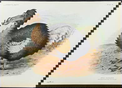
Rothschild, Extinct - Dodo Bird (Didus Cucculatus) with 3 Additional Outline PlatesTrillium Antique Prints & Rare Books4.5(30)See Sold PriceFeb 24, 2024
1738 BIBLE in DUTCH ILLUSTRATED w/ MAPS MASSIVE FOLIO in DUTCH antique BIBLIAJasper524.5(9.8k)See Sold PriceFeb 27, 2024
1749-1771 HISTORY OF ROMAN EMPERORS 12 VOLUMES antique ILLUSTRATED w/ MAPSJasper524.5(9.8k)See Sold PriceFeb 27, 2024
3 Vintage The World Lithographs, By JanssonThe Benefit Shop Foundation Inc.4.3(2.9k)See Sold PriceMar 13, 2024
Lot Of Mid Century Ephemera, Including Maps & 1957 License PlatesClark's Auction Company4.6(440)See Sold PriceMar 03, 2024
Per Olof Christopher Aurivillius (1843-1928) - Set of 3 Prints - ButterfliesProverde Auctions4.3(3)See Sold PriceFeb 28, 2024


![[CITY VIEW/FRANCE]. N[icholas] Cochin. Arras (1 of 1)](https://p1.liveauctioneers.com/179/10971/2682707_1_x.jpg?height=282&quality=70&version=1162265652)


![[Map] "Le Siege d'Arras" Paris, 1654 (1 of 7)](https://p1.liveauctioneers.com/523/48656/22613836_1_x.jpg?height=282&quality=70&version=1386104939)