Sold3 Map Prints2 are approx 21" x 23" and other is 21" x 24".Believed to be decorator prints.See Sold Price
SoldGrp: 3 Maps Eastern Europe Ukraine Romania BlaeuGroup of three maps of Eastern Europe. Includes one map of Walachia, Serbia, Bulgaria, and Romania by Willem Janszoon Blaeu (1571-1638); one map of Slovenia, Croatia, and Bosnia by Blaeu after GerarduSee Sold Price
SoldEarly New York, MacCoun, (3) maps, 1909Early New York, MacCoun, (3) maps, 1909, Townsend MacCoun, Early New York. (3) color maps (of 5 called for) in a paper covered linen folder, printed by L. L. Poates, "New Amsterdam 1653-1664" and "NewSee Sold Price
SoldGrp: 3 Maps of New York CityGroup of three maps of New York City. Includes Mark Tiddeman, "A Draught of New York from the Hook to New York Town," London: W. Mount & T. Page; "Map of New York and the Adjacent Cities," New York: JSee Sold Price
Sold3 maps incl: De Vaugondy. L'EMPIRE DE LA CHINE.[Asia/China/Britain/Mideast] 3 Maps: ++ Robert de Vaugondy. L’EMPIRE DE LA CHINE Dressee d’Apries les Cartes de l’Atlas Chinois. [No date in cartouche. The same engraving plate was used for theSee Sold Price
Sold(3) Maps of Civil War Washington DC Inc. Johnson'sGroup of (3) maps of Civil War-era Washington, DC: a) 1863 Johnson’s Georgetown And The City Of Washington The Capital Of The United States Of America. Johnson and Ward, (nd). From an edition oSee Sold Price
Tallis: 3 Maps of Russia in Asia, Europe, Tartary, 1851Map: 1851 Three Tallis Maps of Russia in Europe, Russia in Asia, Tartary, all in Book -- The History of Russia containing Russia in Asia; Part of Russia and Independent Tartary; Russia in Europe ShowiSee Sold Price
Sold3 MAPS - SAVANNAH RIVER GEORGIA, EAST INDIA3 MAPS - SAVANNAH RIVER GEORGIA APPROX. 22.5" X 33.5" , AND 2 EAST INDIA - APPROX. 26" X 41"See Sold Price
SoldRichard William Seale (1732-1775), "Foldable 3 Map SetRichard William Seale (1732-1775), "Foldable 3 Map Set of England, Ireland, and Scotland," 1750, paper on linen, Each.- H.- W. - 46 in. (3 Pcs.)See Sold Price
SoldGrp: 3 Maps of the Caribbean and BarbadosGroup of three maps of the Caribbean. Includes two maps of the overall region, one by Nicolaes Visscher, which depict the Gulf Coast, Florida, the Caribbean, and northern South America. With one map oSee Sold Price
Sold3 MapsIncluding North America after Matthew Seutter, approx. 18" x 21" sight, 21" x 24" framed; "East Indies," approx. 9" x 12" sight, 16" x 19" framed; "Britannia Antiqua," approx. 9" x 7" sight, 14" x 12"See Sold Price
Sold1858 Mitchell Map of North America -- No. 3 Map ofTitle/Content of Map: 1858 Mitchell Map of North America -- No. 3 Map of North America Date: 1858, Philadelphia Cartographer: S Mitchell Size: 10.8 x 8.3 in. A very nice map of North and Central AmeriSee Sold Price
Sold3 Maps incl: La Peninsola Delle Indie...[Asia (Southeast)/Italy]. 3 Maps engraved by Giovanni Maria Cassini (credited in margin at lower right). Each from From “Nuovo Atlante Geografico Universale…” Framed under glass, not examined ouSee Sold Price
Sold3 Maps: 2 of Asia (De Vaugondy, Sayer) + 1 Japan.[Asia]. 3 Maps. Variously hand-colored. ++ Carte De L’Asie dressee sur les Relations les plus Nouvelles, principalement sur les Cartes de Russie, de la Chine, et de la Tartarie Chinoise… Robert deSee Sold Price
SoldLands of the Arid Region by Powell 1879 (3 Maps)Report of the Lands of the Arid Region of the United States with a More Detailed Account of the Lands of Utah by J. W. Powell. Second Edition. 1879. Government Printing Office, Washington. 195 pp. witSee Sold Price
Sold3 Maps of Indian Reservations3 Maps of Indian Reservations in Sandusky Co. Ohio, 11” x 25” Projectile Point Poster with frame and a Indian Wars Flag HolderSee Sold Price
SoldAtlas - La Croux, N. 1805 Geographie Moderne, 3 Maps"Geographie Moderne" by Abbe Nicolle de La Croix. Vol 1 Only. Paris: Dezalain, 1805. 12mo (175 x 100mm) Complete with 3 Folding Copper Engraved Maps, incl fine Hemispheres, also Europe and France. ConSee Sold Price
SoldGoldsmith 1842 Group of 3 Maps. Europe, Asia, AfricaSteel Engraved Maps Published 1842, London for "Goldsmith's Grammar of Geography" by W. S. Kenny and the Rev. Goldsmith. Folds as issued. Paper Size: 7.5 x 6 inch (19 x 15cm) One with minor toning. TiSee Sold Price
SoldBryce, James 1881 Group of 3 Maps. Roman EmpireLithographs Map Published 1881, London for ""The International Atlas and Geography..." by James Bryce. Maps by Edward Weller & John Bartholomew. Uncommon. Paper Size: 13.5 x 10 inch (34 x 25cm) and 18See Sold Price
SoldCATLIN, George (1796-1872). North American Indians. Philade...CATLIN, George (1796-1872). North American Indians. Philadelphia: Leary, Stuart and Company, 1913. 2 volumes, royal 8vo. 180 color-printed plates including 3 maps (one folding). Original red pictorialSee Sold Price
SoldMilitary Foot Locker and 1918 Map of Vosges Alsace1940's 12th Engineers RY military foot locker chest/trunk of LT. C.H. Kinney with 3 maps of 1927 France including on framed map of 1918 "Vosges Alsace" of allied movement along the front by Carte-CampSee Sold Price
SoldTo Far Western Alaska by Hubback 1ST ED SCARCE DJTo Far Western Alaska for Big Game by Theodore R. Hubback, with 67 illustrations from photographs and 3 maps. 1929, first edition with SCARCE dust jacket unclipped. Rowland Ward, London. 232 pp. GreenSee Sold Price
Sold1569, Biblia Sacra, Folio, LyonBIBLIA SACRA, AD VETUSTISSIMA EXEMPLARIA CASTIGATA…. Lyon: Rouillium, 1569. 13" x 8.75". [6], 394, [55, of 66] leaves, plus 3 maps (of 4.) Rebound in modern full calf. ************** An attractiSee Sold Price
DUNLEVIE c1856 Map Counties Of Gaspe & Bonaventure Quebec Canada SCARCE! #1Luis Porretta Fine Arts4.3(10)See Sold PriceMar 02, 2024
LI XIONGCAI'S EXQUISITE PAPER-BASED LANDSCAPE MAP VERTICAL AXISMega International Auction4.3(62)See Sold PriceFeb 24, 2024
1938 American Armies and Battlefields by the American Battle Monuments CommissionNorth American Artifact Auctions4.7(198)See Sold PriceApr 20, 2024
Chatelain - 3 Maps of the British Isles (England, Ireland, Scotland)Trillium Antique Prints & Rare Books4.5(32)See Sold PriceFeb 24, 2024
1675 ELZEVIER JULIUS CAESAR antique ILLUSTRATED w/ MAPS ROMAN HISTORYJasper524.5(9.9k)See Sold PriceFeb 27, 2024
1738 BIBLE in DUTCH ILLUSTRATED w/ MAPS antique MASSIVE FOLIO BIBLIAJasper524.5(9.9k)See Sold PriceFeb 27, 2024
Emory's Notes of a Military Reconnoissance larger issuePBA Galleries4.7(385)See Sold PriceMar 07, 2024
ANTIQUE 1686 OPERA OMNIA BY JOHN LIGHTFOOT TELLIMA BOUND FOLIO WITH ISRAEL MAPNY Elizabeth 4.2(86)See Sold PriceMar 03, 2024
Set of 3 Maps - Netherlands - Belgien - Switzerland - J. BarlowProverde Auctions4.3(3)See Sold PriceFeb 28, 2024
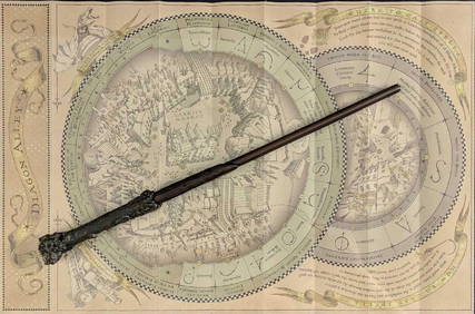
Universal Studios Harry Potter Wand BRapid Estate Liquidators and Auction Gallery4.5(1.1k)See Sold PriceFeb 28, 2024
Virginia and West Virginia Topography MapsRapid Estate Liquidators and Auction Gallery4.5(1.1k)See Sold PriceFeb 28, 2024