Sold3 Hand-Colored Engraved New England Maps3 hand-colored engraved New England maps including the states of Rhode Island, Vermont and New Hampshire. "Lon E. from Philada" on lower margin of all three. All most likely engraved by Joseph T. ScotSee Sold Price
SoldPtolemaeus, Claudius123. Ptolemaeus, Claudius.Polonia et Hungaria Nuova Tavola. Hand-colored engraved map. 7-3/4 x 10-1/4 inches, including margins, neatly matted, in glass-fronted frame. Venice, 16th-century [100/150]FrSee Sold Price
SoldFour Clipped Miniature Antique MapsEngraved and hand colored maps with Latin notations depicting 1. New England [3 5/8" x 2 3/8"]. 2. Bermuda [Sight: 4 1/8" x 5 7/8"]. 3. Cuba and Jamaica [5 7/8" x 4 1/16"]. 4. Greece [3 3/4" x 5 1/4"]See Sold Price
SoldHand colored engraved map of New England, Carte de laHand colored engraved map of New England, Carte de la Nouvelle Angleterre Nouvelle York, Nouvelle Jersey, et Pennsylvania, sight size 7 1/2" x 9"See Sold Price
Sold18th C. Hand-Colored Map of New EnglandAn 18th C. hand-colored engraved map of New England, Nova Scotia, New France, or Canada, with the Islands of Newfoundland, Cape Breton, St. John's, by Jacques-Nicholas Bellin. Framed under glass. MatSee Sold Price
SoldFour Antique Hand Colored MapsA grouping of four small framed hand-colored engraved maps to include New England and New York by John Seller, A Mapp of the World by John Seller, Terra Firma, and Moscovia (Moscow) of Russia. All inSee Sold Price
Cary: Antique Map of New England, 1811An original hand colored engraved 1811 map titled ""A New Map of Part of the United States of North America Containing New York, Vermont, New Hampshire, Massachusets, Connecticut, Rhode Island, PennsySee Sold Price
SoldJohn Speed and Francis Lamb Map of New England and NewJohn Speed and Francis Lamb Map of New England and New York. Ca. 1676. Hand colored engraved map with depictions of animals including beavers, elk, bears. Center fold present. Toning and light discoloSee Sold Price
Sold5 pieces. Hand-Colored Engraved Maps - North Amer5 pieces. Hand-Colored Engraved Maps - North America: Moll, Herman. New England, New York, New Jersey and Pennsylvania & C." [London], [ca. 1740]. 7 x 10 1/2 inches; 200 x 270 mm. Old color. Framed. *See Sold Price
SoldColton: Antique Map of Palestine (Israel), 1861Map: Colton's Palestine (Israel) Date Printed: 1861 Cartographer: J. H. Colton Material/Medium: Paper Size: 14" x 17 1/3" Condition: Excellent Hand colored, steel engraved. Printed in New York. From 'See Sold Price
SoldJohnson: Antique Map of China, 1868Map: Johnson's China Date Printed: 1868 Cartographer: A.J. Johnson Material/Medium: Paper Size: 18" x 13 1/3" Condition: Excellent Hand colored, copperplate engraved. Published in New York. From JohnsSee Sold Price
SoldReinier and Joshua Ottens Map of New England and NewReinier and Joshua Ottens Map of New England and New York Manhattan Totius Neobelgii Nova et Accuratissima Tabula, engraved hand colored map by Reiner (d. 1750) and Joshua Ottens (d. 1765) Typis IoaSee Sold Price
SoldBLAEU, WILLEM. Nova Belgica et Anglia Nova.BLAEU, WILLEM. Nova Belgica et Anglia Nova. Double-page engraved map of New England oriented with north to the right. 18½x23 inches sheet size, wide margins, Latin text on verso; hand-colored inSee Sold Price
SoldJEFFERYS, THOMAS. A Map of the most InhabitedJEFFERYS, THOMAS. A Map of the most Inhabited part of New England. Engraved 4-sheet map with horizontal sheets joined, 1080x1000 mm, wide margins; hand-colored in outline; scattered heavy browning, fiSee Sold Price
SoldJohn Speed, Map of New England & New York, c.1676John Speed, A map of New England and New York. Double-page copper engraved map, hand-colored, c.1676. "Sold by Tho. Basset in Fleet Street and Richard Chiswell in St. Paul's Church Yard". Typically reSee Sold Price
SoldBlaeu map of New England and New Yourk 1635Heading: Author: Blaeu, Willem Title: Nova Belgica et Anglia Nova Place Published: Amsterdam Publisher: Date Published: 1635 Description: Copper-engraved map, hand-coloredSee Sold Price
SoldJansson map of Virginia & New England 1647Heading: Author: Jansson, Jan Title: Nova Belgica et Anglia Nova Place Published: Amsterdam Publisher: Date Published: 1647 Description: Copper-engraved map, hand-colored in outSee Sold Price
SoldJacques Nicolas Bellin Map. New York and PennsylvaniaJacques Bellin (French, 1703-1772). Hand colored engraved map. Carte De Nouvelle, Angleterre. Nouvelle York, et Pensilvanie. Includes Eastern Pennsylvania along with New York and New England. UnframedSee Sold Price
SoldHand-Colored Engraved Map. Fisher, WilliHand-Colored Engraved Map. Fisher, William; Mount, Richard. "A New Chart for the Seacoasts of Newfoundland, New Scotland, New England, New Jersey, Virginia and Maryland." [London], [ca. 1690]. Approx.See Sold Price
SoldOrtelius, Abraham115. Ortelius, Abraham.Galliæ Veteris typus. Hand-colored engraved map. 17 x 21 inches, including margins, glass-fronted-frame; some browning at margins. Antwerp, Circa 1590s [150/250]See Sold Price
SoldAntarcticaTitle/Content of Map: Antarctica Date Printed: 1861 Cartographer: J.H. Colton Material/Medium: Paper Size: 14" x 17 1/3" Hand colored, steel engraved. From 'Colton's General Atlas.' Published in New YSee Sold Price
SoldMercator, Gerard97. Mercator, Gerard.Le Diocese de Sarlat. Fine hand-colored engraved map, French text on verso. 19 x 24-1/2 inch double-page map, matted; scattered foxing. Amsterdam: Henricus Hondius, Circa 1630s [2See Sold Price
SoldOrtelius, Abraham116. Ortelius, Abraham.Barbariae et Biledulgerid Nova Descriptio. Hand-colored engraved map. 17 x 21 inches, including wide bottom margin, in glass-fronted frame; light browning. London, Circa 1600 [2See Sold Price
SoldOrtelius, Abraham110. Ortelius, Abraham.Schlavoniae, Croatiae, Carniae, Istriae, Bosniae, Finitimarumque...Augustino Hirsvogelio. Hand-colored engraved map. 13 x 18 inches plus margins, neatly matted, in glass-frontedSee Sold Price
LATE 18TH C. VERY LARGE CHART OF NORTHEAST CANADA BY DES BARRES (1721-1824), 1780, FRAMEDThomaston Place Auction Galleries4.4(386)See Sold PriceFeb 24, 2024
VENET / DEBUCOURT (1755-1832) Set 3 x Aquatint Engraved Hunting Scenes 23" x 16"Luis Porretta Fine Arts4.3(10)See Sold PriceMar 02, 2024
17th Century Hand Colored Engraved Map of GermanyGlobal Auctions Company4.3(36)See Sold PriceMar 03, 2024
18th Century Hess Germany Hand colored Engraved MapGlobal Auctions Company4.3(36)See Sold PriceMar 03, 2024
[MAP]. [ALBRIZZI, Giambatista, 1698-1777]. Carta Geografica...Potter & Potter Auctions4.6(539)See Sold PriceMar 07, 2024
Hand Colored Engraved Map of Europe, Jean Baptiste Bourguignon Anville 1754Global Auctions Company4.3(36)See Sold PriceMar 03, 2024
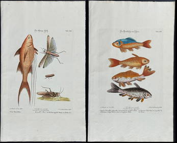
Edwards & Seligmann - 3 Fish EngravingsTrillium Antique Prints & Rare Books4.5(30)See Sold PriceFeb 24, 2024
Herman Moll A New Map of Ye North Parts of AmericaWillow Auction House4.5(283)See Sold PriceMar 14, 2024


![[MAP]. [ALBRIZZI, Giambatista, 1698-1777]. Carta Geografica... (1 of 1)](https://p1.liveauctioneers.com/928/318880/171361280_1_x.jpg?height=282&quality=70&version=1707501302)