SoldHawaii Antique Maps - Framed Set of 3 (125100)A set of three framed maps of Hawaii, also called the Sandwich Islands, pre-statehood. Professionally mounted, exquisitely matted (see photos), and framed -- two with glass, one without. Largest is frSee Sold Price
Sold4 FRAMED MAPS, 3 ANTIQUE & 1 CONTEMPORARYREGNO DI FRANCIA D.1776, 16" X 12"; PROVINCE OF NEW YORK, 1776, COPY, SIGHT 26 ½" X 21";NORTH AFRICA, SIGHT 14 ½" X 19"; ENGRAVING OF ANCIENT TOWNSCAPE 12" X 18 ½"See Sold Price
SoldSet of 2 Framed Prints of Antique MapsSet of 2 Framed Antique Maps - Small map of England and Scotland. Large Map of the Mediterranean with ships. Measures approx. Large map 28" tall x 31" w x 1" deep. Small map 12" tall x 15" w x 3/4" deSee Sold Price
SoldMap: Americae Sive Novi Orbis, Nova DescriptioFramed antique map, America. Americae Sive Novi Orbis Nova Descriptio. Smaller format, sight sheet measurement 3.5" x 4.75". Framed and matted under glass measuring 10.5" x 11.5".See Sold Price
SoldTwo Antique Framed MapsA pairing of two antique framed maps: a colored map of France dated 1627, and a map of Asia dated 1744. Both in gilt frames under glass. Map of Asia: 19-3/4 x 20 in.See Sold Price
Sold(2) ANTIQUE IRELAND MAPSCarte D' Irlande map published in 1867 by Alvin J. Johnson New York. Measures 10 3/4" x 15 3/4" (Framed 19 1/2" x 23 1/2") and a Jacques Nicolas Bellin A Chart of Ireland 1803 hand colored map. MeasurSee Sold Price
SoldAntique Miniature Map: OrmusEarly map by Petrus Bertius, (1565 -1629) Flemish philosopher, theologian, mathematician, and cartographer of the historical kingdom and city-state of Ormus. c. 1597, 7.5" ht. x 9.5" wd framed, 3.75"See Sold Price
Sold2pcs Decorative Antique Maps FRAMED GEOGRAPHY MADE EASYDetails: 2pcs Decorative Antique Maps FRAMED GEOGRAPHY MADE EASY JEDIDIAH MORSE 1798 Map Of North America & World Map American Universal Geography Collectible This group features 3 matted and framedSee Sold Price
Sold.18th Century French Map of Cuba, Florida and Louisiana21 1/4 x 16 3/4 in. (framed).18th Century French Map of Cuba, Florida and LouisianaGulf of Mexico antique map Golfe du Mexique Zannoni 1762Title: Carte Geo-Hydrographique du Golfe du Mexique et de sesSee Sold Price
Sold(3) MAPS, MERCATOR'S PROJECTION, WESTERN EUROPEAntique maps: (1) framed map of the West Indies from George Washington Colton's 1855 Atlas of the World, page 56, Bermuda Islands inset at upper right above the Havana harbor, sight: 13.5"h, 16.5"w, oSee Sold Price
SoldThree Antique New Orleans MapsThree Antique New Orleans Maps, 18th c., incl. 2 from Bellin's Petit Atlas Maritime and one published by London Magazine, sights 7 1/2 in. x 9 in. to 8 1/2 in. x 11 3/4 in., framed alikeSee Sold Price
SoldAntique French Buache map of the Carribean and GulfAntique French JN Buache map of the Gulf of Mexico, Caribbean, Antilles and West Indies. Sight size 19 3/4"h x 36 3/4" w Framed size 28"h x 45"wSee Sold Price
SoldAntique Map of Volga RiverCartographer, Adam Olearius. Hand colored engraving, 16th/17th century. In two parts. Sight size 19 3/4 x 23 inches. Framed. Notice to bidders: Condition reports and additional photographs are provideSee Sold Price
SoldTHREE FRAMED PCS OF ARTWORK - MAPSFramed Liberty of London silk scarf with antique map of Bermuda - 26 1/4" x 26 1/2", framed atlas map of Estonia 12 3/4" x 9" & Florentine plaque with map of Bermuda - 9" x 7 3/4"See Sold Price
Sold2 VINTAGE / ANTIQUE MAPSTwo Framed Maps. 1- Town of Patterson, Putnam County NY. In Frame 17"x14"x3/4". 2- Vintage Reproduction of A New and Accvat Map of the World. 16 3/4"x21 3/4"x3/4". Weight combined 7 pds.See Sold Price
SoldAntique Map of Louisiana, Carey & Lea, 1822Antique Map of Louisiana , "Geographical, Statistical and Historical Map of Louisiana", Philadelphia, Carey & Lea, 1822, 16 3/4 in. x 21 1/4 in., framed . Provenance: By repute, Arader Galleries, NewSee Sold Price
Sold3 Antique Maps of Continental EuropeApprox. 19" H x 22" W sight, 25" H x 28" W framed. (5229) Wear to frames.See Sold Price
Sold3 Antique MapsTwo signed Andrade. One of armillary sphere, one of Scandinavia & North & South America, one of Africa & Greece. All approx. 9 1/2" x 10" framed. From the estate of Arthur Adlman, New York, NY and CasSee Sold Price
SoldANTIQUE MAPS FOUR PIECESANTIQUE MAPS, FOUR PIECES, H 9 - 11":Including a framed map of the West Indies, H.11 3/4 x 21 1/4", inscribed at the lower middle: "Published as the Act directs January 1st, 1785 by C. Dilly and G. RoSee Sold Price
SoldLOT OF 3 ANTIQUE MAPS 1850 FLORIDA SURVEY MAPSTwo 1850's North Florida survey maps, Arredondo Grant and South Boundary of General Coffees Survey. Both framed, measuring 15 X 8 inches. Lot also includes Diagram of Tallahassee Land District map, frSee Sold Price
SoldSet 3 Framed Maps. The World, Canada, and MediterraneanSet 3 Framed Maps. The World, Canada, and Mediterranean. -- Dimensions: H: 13.5 inches: W: 18 inches ---See Sold Price
Sold3 Southwestern Maps3 Framed Southwestern Maps. 1st item: Map showing the Southern boundary of New Mexico, agreed upon by Commissioners Bartlett & Conde, February 7, 1853. 11 1/4" x 7 1/2" sight, 19 1/2" x 15 3/4" mattedSee Sold Price
SoldAntique Map Devonshire Robert Morden c1695Antique map from Camden's Britannia engraved by Robert Morden (English, c1650-1703). Map measures 14 1/8” tall, 16 3/8” wide (35.9 x 41.6 cm) to outer neat line. Framed under glass.See Sold Price
Sold4 TN & KY Maps, 3 Framed1st item: "Tennessee" Map, by Anthony Finley, engraved by Young and Delleker, published by Anthony Finley, Philadelphia, 1824. From "A New General Atlas, Comprising a Complete Set of Maps" by AnthonySee Sold Price
Framed Antique Apparatus "Bubbler" Jukebox PosterDutch Auction Company4.3(2)See Sold PriceFeb 24, 2024
Vintage Estate World Maps II Signed & Framed Art PrintMannys Jewelry4.6(333)See Sold PriceMar 03, 2024
17TH C. ANTIQUE MAP SIEGE OF LA ROCHELLE, FRANCE, FRAMEDThomaston Place Auction Galleries4.4(389)See Sold PriceFeb 24, 2024
18TH C. ANTIQUE MAP: FRENCH & INDIAN WAR, FRAMEDThomaston Place Auction Galleries4.4(389)See Sold PriceFeb 24, 2024
Framed Hand Colored Antique Map of the Department of Nord, FranceDonny Malone Auctions4.4(1.8k)See Sold PriceMar 04, 2024
Chatelain - 3 Maps of the British Isles (England, Ireland, Scotland)Trillium Antique Prints & Rare Books4.5(30)See Sold PriceFeb 24, 2024
D'Entrecasteaux - Australia: Chart of Van Diemen's Land (New Holland). 3Trillium Antique Prints & Rare Books4.5(30)See Sold PriceFeb 24, 2024
Raphael - Religious Fresco or Decorative Pilaster. 3Trillium Antique Prints & Rare Books4.5(30)See Sold PriceFeb 24, 2024
Donovan's The Natural History of British Shells - 5 Volumes in 3 Books with 180 EngravingsTrillium Antique Prints & Rare Books4.5(30)See Sold PriceFeb 24, 2024
Edwards & Seligmann - 3 Fish EngravingsTrillium Antique Prints & Rare Books4.5(30)See Sold PriceFeb 24, 2024
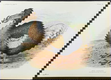
Rothschild, Extinct - Dodo Bird (Didus Cucculatus) with 3 Additional Outline PlatesTrillium Antique Prints & Rare Books4.5(30)See Sold PriceFeb 24, 2024
MALLET. Description de l'Univers. Africa. Volume 3 title page. MALLET 1683Jasper524.5(9.8k)See Sold PriceFeb 28, 2024
Framed Antique Sheet Music CoversRapid Estate Liquidators and Auction Gallery4.5(1.1k)See Sold PriceFeb 25, 2024
Paul Louis Oudart - Set of 3 Antique Prints - Herpetology, Reptile - Bernard Germain Etienne De LaProverde Auctions4.3(3)See Sold PriceFeb 28, 2024
Framed Antique Signed J. Haller Engraving PrintRapid Estate Liquidators and Auction Gallery4.5(1.1k)See Sold PriceMar 01, 2024
Map of United States of North America, 1785Antiques Online Auctions4.6(410)See Sold PriceMar 14, 2024
Antique Map of Poland, 1700 by Guillaume De Lisle, ParisAntiques Online Auctions4.6(410)See Sold PriceMar 14, 2024
Antique Map of France, 1703 by Gillaume Del Isle PrintAntiques Online Auctions4.6(410)See Sold PriceMar 14, 2024
Group of six wood framed antique windowsBaker's Antiques and Auctions3.2(468)See Sold PriceMar 03, 2024