Sold2V CONSTITUTIONS DES TREIZE ETATS-UNIS DE L'AMERIQUETitle: Constitutions des Treize Etats-Unis de l'Amerique Author: uncredited author Publisher: [Uncredited publisher] City: Paris Year: 1792 Printing Information: Second Edition<See Sold Price
SoldVOLUME-CONSTITUTIONS DES TREIZE ETATS-UNIS DE L'AMVOLUME-CONSTITUTIONS DES TREIZE ETATS-UNIS DE L'AMERIQUE, NOUVELLE ED PARIS 1792 (SIGNED AND INSCRIBED "TO SENATOR JOE CLARK BY FRANCOIS MITTERAND 1966)See Sold Price
Sold1st French Edition of the US Constitution and Bill ofHeading: (United States Constitutions) Author: Title: Constitutions des Treize Etats-Unis de l'Amérique Place Published: Paris Publisher:[n.p.] Date Published: 1792 Description:See Sold Price
Constitution des Etats-Unis de l'Amerique 1791First translation of the US Constitution in French?M. De La Croix, Constitutions des principaux etats de l'Europe et des Etats-Unis de l'Amerique, a Paris chez Buisson 1791. 2 octavo volumes, 439-408See Sold Price
SoldMAP, Eastern US, Covens/MortierEastern United States. Jean Covens & Corneille Mortier, Carte Generale des Treize Etats Unis, de l'Amerique Septentrionale / Kaart van de Dertien Verenigde Staaten, in Noord Amerika, 1783 (circa). HanSee Sold Price
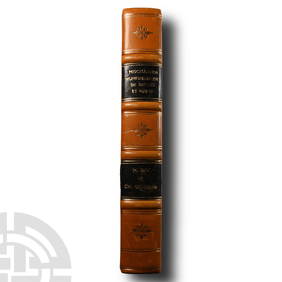
Sold[Americana] [Franklin, Benjamin], Constitutions des[Americana] [Franklin, Benjamin] Constitutions des treize etats-unis de l’Amerique Paris: (no publisher), 1792. Second French edition. Two volumes in one, with separate title-page for second volume.See Sold Price
SoldWorld.- Covens & Mortier. Publishers. [Atlas NouveWorld.- Covens & Mortier. Publishers. [Atlas Nouveau],with 32 double-page maps, including Carte du Mexique et de la Floride, Carte Generale des Treize Etats Unis de l'Amerique Septentrionale,See Sold Price
SoldFrancois Barbe-Marbois HISTOIRE DE LA LOUISIANE 1829Title: Histoire de La Louisiane et de la cession de cette colanie par la France aux Etats-Unis de L'Amerique Septentrionale; precedee d'un discours sur la Constitution et le Gouvernement des Etats-UniSee Sold Price
Sold1778 FRENCH PRINTING OF AMERICAN CONSTITUTIONSUNITED STATES. Recueil des Loix Constitutives des Colonies Angloises, Confédérées sous la Dénomination D'États-Unis de l'Amérique-Septentrionale. A Philadelphie et se vend a Paris: Chez CellotSee Sold Price
SoldMap, United States, 1784, first map of the nationMap, United States, 1784,"Carte Des Etats-Unis De L'Amerique Suivant le Traite de Paix de 1783. Dediee et Presentee A.S. Excellence M. Benjamin Franklin Ministre Pleinipotentaire des Etats-Unis", theSee Sold Price
SoldFrench Map of Southeastern"United States [Carte De la Partie Sud Des Etats Unis De L'Amerique Septentrionale,] Rigobert Bonne (French, 1727-1795), Paris, circa 1780, engraving on laid paper, hand-colored in outline, 8-3/4 x 13See Sold Price
Bonne: Antique Map of Northeastern USA, 1780Title/Content of Map: 'Carte de la Partie Nord des Etats Unis de l'Amérique Septentrionale' A map of the northeastern United States: Mid-Atlantic States and New England Date Printed: 1780 Image Size:See Sold Price
Bonne: Antique Map of Northeastern USA, 1780Title/Content of Map: 'Carte de la Partie Nord des Etats Unis de l'Amérique Septentrionale' A map of the northeastern United States: Mid-Atlantic States and New England Date Printed: 1780 Image Size:See Sold Price
Bonne: Antique Map of the Carolinas, 1780Title/Content of Map: 'Carte de la Partie Sud des Etats Unis de l'Amérique Septentrionale' A map of the Carolinas & Georgia Date Printed: 1780 Image Size: Approx 23.0 x 34.0cm, 9 x 13.5 inches (LargeSee Sold Price
SoldFramed map, Rigobert Bonne, Northeastern US, 1787Framed handcolored map, Rigobert Bonne, Carte De La Partie Nord, Des Etats Unis, de l' Amerique Septentrionale, Northeastern United States, from Raynal's ''Atlas d.les Deux Indes'', Geneva, J.L. PelleSee Sold Price
SoldBuchon: Antique Map of USA territorial developmentTITLE/CONTENT OF MAP: 'Carte de l'adjonction progressive des divers états au territoire et à l'union constitutionelle des États-Unis de l'Amérique du Nord 1825' This fascinating map shows the terrSee Sold Price
SoldWarden, D. B Description America 1820Amerika - - Warden, D. B. Description statistique, historique et politique des États-Unis de l'Amérique septentrionale, depuis l'époque des premiers établissements jusqu'a nos jours. Edition traduSee Sold Price
Sold1784 Map After Benjamin FranklinCarte des Etats-Unis de l'Amerique, after Benjamin Franklin 1784, 25" x 33" framed.See Sold Price
Sold1800 Weld Map of Northern United States and Great LakesTitle: 1800 Weld Map of Northern United States and Great Lakes -- Partie des Etats-Unis de L'Amerique Septentrionale Cartographer: I Weld Year / Place: 1800, Paris Map Dimension (in.): 16.1 X !8.2 in.See Sold Price
Sold(1797) Map of the Eastern United States + CanadaHistoric Maps Federal Period Hand-Colored Map of the United States Early (1797) Hand-Colored Map of the Eastern United States and Canada. "Carte Generale des Etats Unis de l'Amerique Septentrionale, RSee Sold Price
Partie Sud des Etats Unis de l'Amérique Septentrionale.Title/Content of Map: 'Carte de la Partie Sud des Etats Unis de l'Amérique Septentrionale' A map of the Carolinas & Georgia Date Printed: 1780 Image Size: Approx 23.0 x 34.0cm, 9 x 13.5 inches (LargeSee Sold Price
SoldFrench Map of Southern United States by M. Bonne, 1Early French Map of Southern United States "Carte de la Partie Sud des Etats Unis de L'Amerique Septentrionale" by M. Bonne, Paris, c. 1780. A rare colored map of the southeastern US printed during thSee Sold Price
SoldEsnauts & Rapilly - Battle of Yorktown, 1782Esnauts & Rapilly (fl. circa 1775-1811), A Map of the Battle of Yorktown entitled Carte de la Partie de la Virginie ou L'Armée Combinée De France & Des États-Unis De L'Amérique a fait prisonniereSee Sold Price
SoldHaym Solomon, Jewish Financier of Rev War and RarestSalomon Haym Haym Solomon, Jewish Financier of Rev War and Rarest Signature of Americana! HAYM SALOMON. Signed check "Pour Compte des Etats Unis de L'Amerique, Philadelphie" accomplished in manuscriptSee Sold Price
LATE 17TH C. FRENCH MAP OF THE NEW WORLD BY ALEXIS-HUBERT JAILLOT (1632-1712)Thomaston Place Auction Galleries4.4(386)See Sold PriceFeb 24, 2024
LARGE EARLY 18TH C. DUTCH CHART OF UPPER NORTH AMERICA, PIERRE MORTIER (1661-1711), FRAMEDThomaston Place Auction Galleries4.4(386)See Sold PriceFeb 24, 2024
Numismatic Books - Miscellanea Numismatique 1872-1891TimeLine Auctions Ltd.4.5(183)See Sold PriceMar 09, 2024
TYLER, John, 10e président des États-Unis d’Amérique / 10th President of theIEGOR Auctions4.2(133)See Sold PriceFeb 28, 2024
Van Houtte - Lady's Slipper OrchidTrillium Antique Prints & Rare Books4.5(30)See Sold PriceFeb 24, 2024
Map: An 18thC engraved and hand coloured map of North America and South America, titled DeClaydon Auctioneers Ltd4.3(125)See Sold PriceFeb 26, 2024
1731 2 volumes SCIENCE in FRENCH by Bernard Fontenelle antiqueJasper524.5(9.8k)See Sold PriceFeb 27, 2024
Van Houtte (Pub) C1860 Pair of Folio Greenhouse Prints. BelgiumAlbion Auctions4.6(336)See Sold PriceMar 07, 2024
1845 Delisle/Bauche Map of Martinique -- Carte de l'Isle de la Martinique Colonie Francoise de l'uneJasper524.5(9.8k)See Sold PriceFeb 27, 2024
WEST AFRICA Niger/Gambia rivers tribes towns. 'Pays des Negres'. MALLET 1683 mapJasper524.5(9.8k)See Sold PriceFeb 28, 2024
1731 TWO VOLUMES ADVANCED SCIENCE IN FRENCH BY BERNARD FONTENELLENY Elizabeth 4.3(84)See Sold PriceMar 03, 2024


![[Americana] [Franklin, Benjamin], Constitutions des (1 of 2)](https://p1.liveauctioneers.com/65/159076/80332937_1_x.jpg?height=282&quality=70&version=1578427354)


![[PRIZE OF WAR] : (1 of 6)](https://p1.liveauctioneers.com/1458/320148/172030900_1_x.jpg?height=282&quality=70&version=1708367366)


