SoldD. Appleton & Co., Publishers (American, 19th Century)D. Appleton & Co., Publishers (American, 19th Century) Railway Map of the United States and Canada. Engraving by Rae Smith with hand-coloring, 1871, unframed 25 1/4" x 28"See Sold Price
SoldEngraved map of Canada and United StatesCarte de la Region Orientale des Etats-Unis et de la dominion du Canada, 19th century, engraved map with hand coloring, designed by A. Brue, overall (with frame): 19.5"h x 25"wSee Sold Price
SoldEngraved map of Canada and United StatesCarte de la Region Orientale des Etats-Unis et de la dominion du Canada, 19th century, engraved map with hand coloring, designed by A. Brue, overall (with frame): 19.5"h x 25"wSee Sold Price
SoldFour 19th Century Maps Pertaining to the Western Unitedas follows: Geological Map of a Part of the State of California Explored in 1855 by Lieut. R. S. Williamson U.S. Top Engr (Washington: War Department, 1856); color-coded (24.5 x 19.25 in.) (Some edgeSee Sold Price
SoldMap of the United States, Photo ofAbraham Lincoln 19th century map of United States, probably a lithograph, marked lower right "Constantine Chase", 14 x 17-3/4 in., gilt metal frame, [not examined out of frame, extensive fading and brSee Sold Price
Sold238. 19th Century Map of the United States, Canada, Tex238. 19th Century Map of the United States, Canada, Texas & Part of Mexico: To Illustrate Olney's School Geography. Creation date 1844. Drawn and engraved by Sherman and Smith, N.Y. This map shows theSee Sold Price
SoldCase Tiffany & Co, Map Of The United States, 1851American, mid 19th century. "Map of the United States", c. 1851, lithograph with color on banknote paper, published by Case Tiffany & Co (American, founded 1836). A map of the United States (includingSee Sold Price
SoldMiller Map of the US with Presidential PortraitsMiller, William (19th Century). Map of the United States (with 13 presidential portraits + Capitol in Washington (unfinished). Engraved map. Ohio: William & Thomas Miller, 1852. 23 ½" x 31" sheet.See Sold Price
19th Century Dissected Map of the United States by19th Century Dissected Map of the United States by McLoughlin Bro's, New York, map is made of heavy cardboard and measures 17 3/4 x 15 3/4 in., box top which is made of cardboard and wood measures 9 1See Sold Price
Sold19th century colored map of Eastern United States19th century colored map of Eastern United States 17" X 19", in antique maple frameSee Sold Price
SoldMap of the United States Solomon Schoyer 1826 EngravingWonderful Early 19th Century Antique Map of the United States - By Solomon Schoyer. Map of the United States Drawn from the Most Approved Surveys. New York: Solomon Schoyer, 1826. An Engraved foldingSee Sold Price
SoldSchoyer's Pocket Map of The United StatesAn early 19th century pocket map of The United States. By Solomon Schoyer, New York, published 1826. Hand colored engraving on paper. Overall discoloration and fading, multiple tears along fold lines,See Sold Price
SoldSix British and American Historical EngravingsGroup of Six British and American Historical Engravings, 19th century, including "Map of The United States of America and Nova Scotia", engraved by Fenner, Sears and Company, published by T. Hinton anSee Sold Price
Sold2 Maps: Early U.S. plus Louisiana and a Polar Map, 19thTwo framed maps, 19th century. One oak framed map of United States east of the Mississippi and Louisiana and one gilt wood framed map of the polar regions.(SBAR2375/2) {PR} Measurements: Oak frame isSee Sold Price
Sold1845 Chapin's Ornamental Map Of The USAmazing 19th century Chapin's Ornamental map of the United States, dated 1845. Fair condition with expected wear for its age. Has expected discoloration, staining, tears, and other damage. Still displSee Sold Price
SoldBenjamin Warner Early 19th Century U.S. MapBenjamin Warner, Philadelphia large early 19th century United States map. Under glass but not mounted or glued, etc. Sheet size 16 3/8" x 24 3/4". Fair condition with toning and splits at fold lines oSee Sold Price
SoldEarly 19th Century hand colored engraved pocket mapEarly 19th Century hand colored engraved pocket map United States of America Corrected and Improved from the Best Authorities, issued by Benjamin Warner, Philadelphia, 1820. Engraved by Hugh Anderson.See Sold Price
SoldEarly 19th Century Hand-Colored Map of the UnitedEarly 19th Century Hand-Colored Map of the United States, matted and framed, 12 x 15.5" (sight). Printed by Thos. T. Ash, 139 Chestnut St. Phila. Missouri is shown with modern boundaries (24th stateSee Sold Price
SoldThree early 19th century U.S. mapsThree early 19th century U.S. maps: "Southern Provinces of the United States", John Thomson, 1815, inset Hudson River scene, 19-3/4 x 23-1/2 in. (sight); "Carte Generale des Etats-Unis", E. Mentelle aSee Sold Price
Sold19th Century United States Engraved Maps19th Century United States Engraved Maps Two maps including 1865 of the 'TERRITORIES & PACIFIC STATES' to accompany 'Across the Continent' by Samuel Bowles, having detailed ancillary map of 'Plan of CSee Sold Price
SoldTwo Mid 19th Century United States Framed Maps1. Hand colored map "United States of North America / North Central Sheet", depicting Midwest with Minnesota Territory pre-Dakota, c. 1863, drawn and engraved by T. Ettling, Weekly Dispatch Atlas; matSee Sold Price
SoldNine (9) Augustus Mitchell MapsCollection of late 19th century United States STATE maps including Minnesota, Iowa and Missouri, State of Maine , Illinois-Missouri-Iowa-Nebraska-and Kansas on one, Two Georgia and Alabama, ConnecticuSee Sold Price
SoldMaps of Various United States of AmericaLarge group of 19th and 20th century maps of parts of the United States. F. H. Gerdes (1809-1884) "U. S. Coast Survey Preliminary Chart of Ship Island Shoal Louisiana" U.S. Coast Survey, Washington DCSee Sold Price
Sold1873 Geography ATLAS MAPS United States Weather Owned1873 Geography ATLAS MAPS United States Weather Owned by Communist Spy ‘An Elementary Treatise on Physical Geography’ is a late 19th-century atlas and geography treatise. Collected by D.M. Warren,See Sold Price
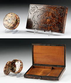
[LITHOGRAPHY]. [CURRENCY]. Group of Six American Currency N...Potter & Potter Auctions4.6(539)See Sold PriceMar 07, 2024
Cigar Store Antique Folk Art Statue Uncle Sam Polychrome Painted Wood Early 20th CenturyCollective Hudson4.5(54)See Sold PriceMar 01, 2024
Mitchell - Map of the City of Washington (Washington, DC)Trillium Antique Prints & Rare Books4.5(30)See Sold PriceFeb 24, 2024
Art Nouveau Brass Fireplace Tool Set Screen Andiron and Log Bucket SetBidhaus4.3(747)See Sold PriceFeb 28, 2024
American School "U.S.M. Adelaide" Oil on PanelAuctions at Showplace4.5(726)See Sold PriceApr 07, 2024
Early Native American Plains Blackfoot Beaded MoccasinsArtemis Fine Arts4.8(1.4k)See Sold PriceFeb 26, 2024
Emanuel Villanis Bohemienne Sculpture H: 25" FranceCarstens Galleries4.5(128)See Sold PriceMar 01, 2024
2PC 19C American Squirrel Wallpaper BandboxesBruneau & Co. Auctioneers4.5(491)See Sold PriceMar 18, 2024
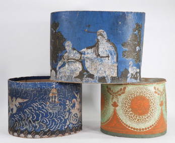
3PC 19C American Neo-Classical Wallpaper BandboxesBruneau & Co. Auctioneers4.5(491)See Sold PriceMar 18, 2024
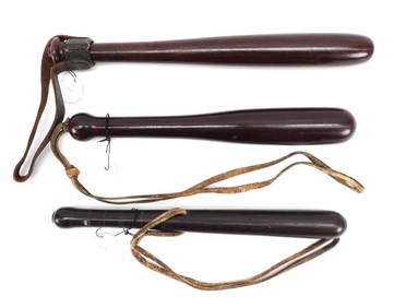
McCord Oak & Brass Siren Clacker NightstickBruneau & Co. Auctioneers4.5(491)See Sold PriceMar 18, 2024
1890 Ebonized Wood Silver Presentation NightstickBruneau & Co. Auctioneers4.5(491)See Sold PriceMar 18, 2024
Vintage Police Officer Portrait PhotographBruneau & Co. Auctioneers4.5(491)See Sold PriceMar 18, 2024
1920s Bakelite Lidded Jar + French Card Case for EcarteArtemis Fine Arts4.8(1.4k)See Sold PriceFeb 26, 2024


![[LITHOGRAPHY]. [CURRENCY]. Group of Six American Currency N... (1 of 2)](https://p1.liveauctioneers.com/928/318880/171361047_1_x.jpg?height=282&quality=70&version=1707501302)