Sold2 maps: ''Rio Colorado of the West'' 1858, pub. 1[Western US]. 2 Maps. Explorations And Surveys. War Department. Map Nos. 1-2. Rio Colorado Of The West. Drawn by F. W. von Egloffstein. 1858. From: Report Upon The Colorado River Of The West, ExploredSee Sold Price
Map No. 1. Rio Colorado of the West - Map No. 2. RioTitle: Map No. 1. Rio Colorado of the West - Map No. 2. Rio Colorado of the West Publicaiton Date: 1858 Cartographer: IVES, JOSEPH CHRISTMAS Publisher: HUMPHREYS, CAPT. A.A./O.E.S. Size: 14Height - 35See Sold Price
J.c. Ives - Geological Map, Rio Colorado Of The West,J.c. Ives - Geological Map, Rio Colorado Of The West, 1858 - 40 X 19 1/8 In. - Giclée On Canvas - Museum Wrapped - Large Piece Of Art - This Piece Is Ready To Hang On Your WallSee Sold Price
J.C. IVES - GEOLOGICAL MAP, RIO COLORADO OF THE WEST,J.c. Ives - Geological Map, Rio Colorado Of The West, 1858 - 40 X 19 1/8 In. - Giclée On Canvas - Museum Wrapped - Large Piece Of Art - This Piece Is Ready To Hang On Your WallSee Sold Price
J.C. IVES - GEOLOGICAL MAP, RIO COLORADO OF THE WEST,J.c. Ives - Geological Map, Rio Colorado Of The West, 1858 - 40 X 19 1/8 In. - Giclée On Canvas - Museum Wrapped - Large Piece Of Art - This Piece Is Ready To Hang On Your WallSee Sold Price
J.C. IVES - GEOLOGICAL MAP, RIO COLORADO OF THE WEST,J.c. Ives - Geological Map, Rio Colorado Of The West, 1858 - 36 X 17 1/4 In. - This Giclée Print Is Gallery Stretched And Ready To Hang Or Lean Against A Wall, Or Display On An Easel. - A Giclée PriSee Sold Price
J.C. IVES - GEOLOGICAL MAP, RIO COLORADO OF THE WEST,J.c. Ives - Geological Map, Rio Colorado Of The West, 1858 - 36 X 17 1/4 In. - This Giclée Print Is Gallery Stretched And Ready To Hang Or Lean Against A Wall, Or Display On An Easel. - A Giclée PriSee Sold Price
J.C. IVES - GEOLOGICAL MAP, RIO COLORADO OF THE WEST,J.c. Ives - Geological Map, Rio Colorado Of The West, 1858 - 40 X 19 1/8 In. - This Giclée Print Is Gallery Stretched And Ready To Hang Or Lean Against A Wall, Or Display On An Easel. - A Giclée PriSee Sold Price
J.c. Ives - Geological Map, Rio Colorado Of The West,J.c. Ives - Geological Map, Rio Colorado Of The West, 1858 - 40 X 19 1/8 In. - Giclée On Canvas - Museum Wrapped - Large Piece Of Art - This Piece Is Ready To Hang On Your WallSee Sold Price
J.C. IVES - GEOLOGICAL MAP, RIO COLORADO OF THE WEST,J.c. Ives - Geological Map, Rio Colorado Of The West, 1858 - 40 X 19 1/8 In. - Giclée On Canvas - Museum Wrapped - Large Piece Of Art - This Piece Is Ready To Hang On Your WallSee Sold Price
J.C. IVES - GEOLOGICAL MAP, RIO COLORADO OF THE WEST,J.c. Ives - Geological Map, Rio Colorado Of The West, 1858 - 40 X 19 1/8 In. - Giclée On Canvas - Museum Wrapped - Large Piece Of Art - This Piece Is Ready To Hang On Your WallSee Sold Price
J.C. IVES - GEOLOGICAL MAP, RIO COLORADO OF THE WEST,J.c. Ives - Geological Map, Rio Colorado Of The West, 1858 - 40 X 19 1/8 In. - This Giclée Print Is Gallery Stretched And Ready To Hang Or Lean Against A Wall, Or Display On An Easel. - A Giclée PriSee Sold Price
J.C. IVES - GEOLOGICAL MAP, RIO COLORADO OF THE WEST,J.c. Ives - Geological Map, Rio Colorado Of The West, 1858 - 40 X 19 1/8 In. - This Giclée Print Is Gallery Stretched And Ready To Hang Or Lean Against A Wall, Or Display On An Easel. - A Giclée PriSee Sold Price
J.C. IVES - GEOLOGICAL MAP, RIO COLORADO OF THE WEST,J.c. Ives - Geological Map, Rio Colorado Of The West, 1858 - 36 X 17 1/4 In. - This Giclée Print Is Gallery Stretched And Ready To Hang Or Lean Against A Wall, Or Display On An Easel. - A Giclée PriSee Sold Price
J.C. IVES - GEOLOGICAL MAP, RIO COLORADO OF THE WEST,J.c. Ives - Geological Map, Rio Colorado Of The West, 1858 - Giclée On Canvas 36 X 17 1/4 In. - A Giclée Print Is The Highest Quality Print Available Today. Because There Is No Visible Dot Screen PaSee Sold Price
J.C. IVES - GEOLOGICAL MAP, RIO COLORADO OF THE WJ.C. Ives - Geological Map, Rio Colorado Of The West, 1858 - Giclée On Canvas - 36 X 17 1/4 In.~~A giclée print falls between serigraph and lithograph in quality. Although they can be made on paper,See Sold Price
J.C. IVES - GEOLOGICAL MAP, RIO COLORADO OF THE WJ.C. Ives - Geological Map, Rio Colorado Of The West, 1858 - Giclée On Canvas - 36 X 17 1/4 In.See Sold Price
Map No. 1. Rio Colorado of the West - Map No. 2. RioPublication Date: 1858 Title: Map No. 1. Rio Colorado of the West - Map No. 2. Rio Colorado of the West Cartographer: IVES, JOSEPH CHRISTMAS Publisher: HUMPHREYS, CAPT. A.A./O.E.S. Height: 14 Width: 3See Sold Price
J.C. IVES - GEOLOGICAL MAP, RIO COLORADO OF THEJ.C. Ives - Geological Map, Rio Colorado Of The West, 1858 - Giclée On Canvas - 44 X 21 In. A Giclée Print Is The Highest Quality Print Available Today. Because There Is No Visible Dot Screen PatterSee Sold Price
J.C. IVES -GEOLOGICAL MAP, RIO COLORADO OF THE WEST,J.c. Ives -geological Map, Rio Colorado Of The West, 1858 - Giclée On Canvas -44 X 21 In. - A Giclée Print Is The Highest Quality Print Available Today. Because There Is No Visible Dot Screen PatterSee Sold Price
SoldMap No. 2 Rio Colorado of the West...Reserve Reduced! Title: Map No. 2 Rio Colorado of the West... Publication Date: 1858 Cartographer: Ives, Lt. Joseph C. Publisher: Floyd, Hon. John B./War Dept. Size: 14.6 X 34.8 Map of eastern NV, norSee Sold Price
SoldMap No. 2. Rio Colorado of the West…Title: Map No. 2. Rio Colorado of the West… Author: U.S. Government Description: Engraved map. 37x88 cm. (14½x34½"), folding as issued.The second in a series of four maps from Joseph C. Ives' RepoSee Sold Price
SoldMap No. 1 Rio Colorado of the West...Reserve Reduced! Title: Map No. 1 Rio Colorado of the West... Publication Date: 1858 Cartographer: Ives, Lt. Joseph C. Publisher: Floyd, Hon. John B./War Dept. Size: 14.8 X 34.8 Map of Colorado RiverSee Sold Price
Explorations and Surveys. War Department. Map No. 1 RioReserve Reduced! Title: Explorations and Surveys. War Department. Map No. 1 Rio Colorado of the West, Publication Date: 1858 Cartographer: EGLOFFSTEIN, FRIEDRICH WILHELM, freiherr VON Publisher: WAR DSee Sold Price
West Anatolia Yastik Rug 2 ft 8 in x 1 ft 5 in (0.81 m x 0.43 m)Nazmiyal Auctions4.4(34)See Sold PriceFeb 25, 2024
Rand McNally Railroad Map of Colorado-1929JM Hobby Supply and Railroad Artifact Auctions4.4(126)See Sold PriceFeb 24, 2024
Grand Trunk Railroad Across the Continent Through Canada Book-1917JM Hobby Supply and Railroad Artifact Auctions4.4(126)See Sold PriceFeb 24, 2024
Union Pacific RR Across The Continent West From Omaha, NE Book-April 2, 1868JM Hobby Supply and Railroad Artifact Auctions4.4(126)See Sold PriceFeb 24, 2024
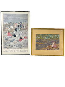
2 Pieces by Maurice Brazil Prendergast (American, 1858-1924), (1) watercolor, signed lower left, artNeely Auction4.6(224)See Sold PriceFeb 25, 2024
Mackenzie-Dow Benchmade Cherry Dining TableNadeau's Auction Gallery4.7(401)See Sold PriceFeb 24, 2024
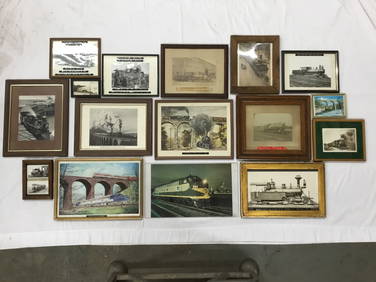
Sixteen Framed Railroad Locomotive Photographs and Prints - Nickel Plate Road, Reading, Erie, andRail & Road Auctions4.6(165)See Sold PriceMar 07, 2024
1905 20th Century Atlas of Boone County IllinoisMatthew Bullock Auctioneers4.7(1.8k)See Sold PriceFeb 24, 2024
1800 MUNGO PARK TRAVELS to AFRICA 2 VOLS w/ MAP antique in ENGLISHJasper524.5(9.8k)See Sold PriceFeb 27, 2024
AFRICA. French West Africa. Rio de Oro Rio Muni Nigeria. BARTHOLOMEW 1952 mapJasper524.5(9.8k)See Sold PriceFeb 28, 2024
Framed Tropical West Indies Map PrintRapid Estate Liquidators and Auction Gallery4.5(1.1k)See Sold PriceFeb 26, 2024
Virginia and West Virginia Topography MapsRapid Estate Liquidators and Auction Gallery4.5(1.1k)See Sold PriceFeb 28, 2024
Antique Pennsylvania Map Fragment incl Wellersburg and New CentervilleCordier Auctions4.4(1.5k)See Sold PriceMar 02, 2024
Vintage Mylflam Diplomat Lighter and EPNS Cigar Ashtray made in HollandJasper524.5(9.8k)See Sold PriceMar 07, 2024