Sold2 Maps incl: Regni Bohemiae Circulus...[Central Europe]. 2 Double-page Engraved Maps. Contemporary full color, very good condition. ++ Circuli Preroviensis Pars Australis, possibly by Homann Heirs. 18 ¼ x 22 ¼”. ++ Regni Bohemiae CircuSee Sold Price
Sold3 Maps incl: Regni Bohemiae... + ...Mecklenburg...[Homann/Central Europe]. 3 Maps. ++ Regni Bohemiae Circulus Rakonicensis ex Mullerianis aliisque recentissimis subsidiis chorographice designatus ut et secundum statum politcium modernum expressus etSee Sold Price
Sold1587 Ortelius hand colored map of Bohemia1587 Ortelius (1527- 1598) hand colored map "Regni Bohemiae Descriptio", from Theatrum Orbis Terrarum, the first modern atlas of the world, sight 13 1/2" x 20 1/2"See Sold Price
Sold2 Maps incl: Aestivarum Insulae... [ca 1680-1700].[Colonial US/Bermuda]. 2 Maps. ++ Aestivarum Insulae at Barmudas. Marks locations of 11 forts, with letters corresponding to a key at lower left. A derivative of John Speed’s map (of 1627), this marSee Sold Price
Sold2 Maps, incl: Map of the Northern & MIddle States[United States]. 2 Maps. ++ A Map Of The States Of Virginia, North Carolina, South Carolina And Georgia: Comprehending the Spanish Provinces of East and West Florida: Exhibiting the Boundaries as fixeSee Sold Price
Sold2 Maps incl: BOWLES’S NEW POCKET MAP... [ca. 1780][Atlantic/Maryland] 2 Maps. ++ BOWLES’S NEW POCKET MAP OF THE ATLANTIC OR WESTERN OCEAN, Laid down from the latest Discoveries, and Regulated by Numerous Astronomical Observations. Lon: Carington BoSee Sold Price
Sold2 Maps incl: L’Empire de la Chine... [c. 1761-92][Asia/China/Indonesia]. 2 Maps. Later hand-colored outline.++ L’Empire de la Chine d’Apres l’Atlas Chinois, avec les Isles du Japon. Engraved by Lattre. From an edition of Bonne’s “Atlas ModSee Sold Price
Sold2 Maps incl: LANCASTRIA PALATINATUS. [c.1640s-50s][Britain/North America]. 2 Maps. ++ LANCASTRIA PALATINATUS ANGLIS LANCASTER ET LANCAS SHIRE. Double-page map by Blaeu, [ca. 1640’s-1650’s]. German text on verso. 15 3/8” x 19 5/8”. Moderate foSee Sold Price
Sold2 Maps incl: Mercator. DESRIPTIO AESTIVARUM.[Caribbean/Bermuda]. 2 Maps. ++ DESCRIPTIO AESTIVARUM. (Title from upper margin. Cartouche: MAPPA AESTIVARUM INSULARUM ALIAS BERMUDAS DICTARUM AD OSTIA MEXICANE…) Mercator, [from an edition of ca. 1See Sold Price
Sold2 Maps incl: Pope. MAP OF THE TERRITORY... 1849.[Midwest/Delaware]. 2 Maps. ++ John Pope. MAP OF THE TERRITORY OF MINNESOTA EXHIBITING THE ROUTE OF THE EXPEDITION TO THE RED RIVER OF THE NORTH, IN THE SUMMER OF 1849. From Report of an Exploration oSee Sold Price
Sold2 Maps incl: County Map of Virginia and West Virgi[Virginia/WV/North Carolina]. 2 Maps. 13 ¼” x 10 ¾”. Sight condition very good. Light, uniform toning. Matted and framed under glass. Not examined out of frames. Prtd. color. ++ County Map of ViSee Sold Price
Sold2 Maps incl. PrussiaIncl. Prussia Thomas Cowperth & Co. 1850 and Sardenia Thomas Cowperth wait & Co. 1850. Overall 20-1/2" high x 24-1/2" wide.See Sold Price
Sold2 Maps incl: Scull and Heap. A MAP OF PHILADELPHIA[United States] 2 Maps. ++ N. Scull and G. Heap. A MAP OF PHILADELPHIA And Parts Adjacent. From the folding map’s 2nd appearance in Gentleman’s Magazine [Lon: Dec. 1777], without the table of distSee Sold Price
Sold2 Maps incl: Smith's Topographical Map Of Virginia[United States] 2 Maps. ++ Smith’s Topographical Map Of Virginia And Maryland. NY: J. C & Rae Smith. Undated but c. 1862. Folding amp of railroads, mountain ridges, and counties. Printed color. 2 inSee Sold Price
Sold2 Maps incl: Il Maryland, Il Jersey Meridionale...[Virginia]. 2 Maps. Matted and framed under glass. Not examined out of frame. ++ Antonio Zatta. Il Maryland, Il Jersey Meridionale, La Delaware, e la Parte Orientale della Virginia, e Carolina SettentSee Sold Price
Sold2 Maps incl: Rudolf Gross. Karte Der Schweiz. 1865[Pocket Maps] 2 Maps. ++ Dr. A. Petermann’s Karte Von Europa Und Dem Mittellandischen Meere. Gotha: Justus Perthes, 1867. 16 sections on orig linen backing, each 10 1/2 x 8 1/2 in. Loose as issued iSee Sold Price
Sold2 Maps incl: GRAECIAE PARS SEPTENTRIONALIS.[Germany/Greece] 2 Maps. ++ Guillelmo Del’Isle. GRAECIAE PARS SEPTENTRIONALIS. Amst: I. Covens et. C. Mortier, (nd). [From an edition of Atlas Nouveau, Contenant Toutes les Partes du Monde, c. 1730sSee Sold Price
Sold2 maps incl Austrian map of New World [c1763-1770[Americas]. 3 engraved maps, outline color. ++ Uibersichts Karte Von America. 2 sheets, for North American, and South America, c.1763-1770. Engraved in lower margin of each map, ''S. V. Adm- 15 Kr. W.See Sold Price
2 Maps incl: Pope. MAP OF THE TERRITORY... 1849.[US/Exploration]. 2 Maps. ++ John Pope. MAP OF THE TERRITORY OF MINNESOTA EXHIBITING THE ROUTE OF THE EXPEDITION TO THE RED RIVER OF THE NORTH, IN THE SUMMER OF 1849. From Report of an Exploration ofSee Sold Price
2 Maps, incl. Napoleonic Theatre de la Guerre,Two (2) early 19th century maps, incl. French Napoleonic and English. 1st item: Map of Theater of War and French and Allied Saxon Marches in Prussia and Poland during the Campaigns of 1806 and 1807 (CSee Sold Price
2 Maps incl: The Ottoman Or Turkish Empire, 1792.[Middle East]. 2 Maps. ++ The Ottoman Othman Or Turkish Empire: In Europe, Asia and Africa. 1792. In lower margin: “Engraved for Jacksons Edition of Paynes New System of Universal Geography.” 13 �See Sold Price
Sold2 Maps incl: Johnson's Virginia Delaware...[Virginia]. 2 Maps. Sight condition near fine. Matted and framed under glass, not examined out of frames. ++ Colton’s Virginia & West Virginia. NY: G. W. C. B. Colton, (copyright 1955). [Ca. 1860’See Sold Price
2 Maps incl: Carte de l'Arabie, du Golfe Persique.[Middle East]. 2 Maps. Matted and framed under glass. Not examined out of frame. ++ Rigobert Bonne. Carte De L’Arabie, du Golfe Persique, et de la Mer Rouge, avec l’Egypte, la Nubie et l’AbissinSee Sold Price
Sold2 Maps incl: La Grece Et Ses Isles, 1788.[Greece/Eastern Europe] 2 Maps. ++ Carte Particuliere De La Hongrie De la Transilvanie De La Croatie Et De La Sclavonie. Paris: Guillaume Delisle, May 1717. Includes rivers, many towns, and place nameSee Sold Price
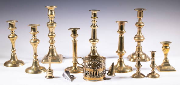
ENGLISH BRASS CANDLESTICK & SNUFFER COLLECTIONThomaston Place Auction Galleries4.4(393)See Sold PriceFeb 24, 2024
Willem Blaeu, Etc. 17th C. Antiquarian Maps, 2Auctions at Showplace4.6(740)See Sold PriceMar 17, 2024
[POETRY]. 2 titles, incl.: BROWN, Sterling. Negro Poetry and Drama. Washington, DC: The AssociatesFreeman's | Hindman4.4(1.6k)See Sold PriceFeb 27, 2024
THE ANTIQUE ILLUSTRATED BOOK "1856 ARCTIC EXPLORATIONS: SECOND GIRNEL EXPEDITION 2" BY E. KANENY Elizabeth 4.2(86)See Sold PriceMar 03, 2024
Antique Pennsylvania Map Fragment incl Wellersburg and New CentervilleCordier Auctions & Appraisals4.4(1.5k)See Sold PriceMar 02, 2024
2 Autographed Footballs incl Phil Simms and Anthony MunozCordier Auctions & Appraisals4.4(1.5k)See Sold PriceMar 02, 2024
2 Autographed Baseballs incl Jason GiambiCordier Auctions & Appraisals4.4(1.5k)See Sold PriceMar 02, 2024
2 Autographed Baseballs incl Bryce HarperCordier Auctions & Appraisals4.4(1.5k)See Sold PriceMar 02, 2024
20 Pcs Vintage Ephemera incl Political Cigar BansCordier Auctions & Appraisals4.4(1.5k)See Sold PriceMar 02, 2024
19th Century Photography incl 2 Ruby Ambrotypes, 1 Tin Type, and 1 Holmes, Booth, and Hayden Gutta PDenotter Auctions, LLC4.6(1k)See Sold PriceFeb 26, 2024
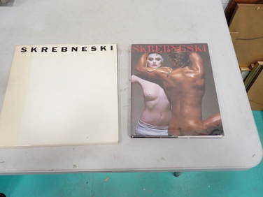
Victor Skrebneski (American, 1929-2020) 2 Books incl a First Edition of "Black, White, & Color PhotoDenotter Auctions, LLC4.6(1k)See Sold PriceFeb 26, 2024
Group of Chanel incl 2 Dustbags, 1 Garment Bag, 1 Allure Box, 4 Empty Bottles of Chanel PlatinumDenotter Auctions, LLC4.6(1k)See Sold PriceFeb 26, 2024
2 Posters incl Museo Tamayo Poster Depicting "Animales" by Rufino Tamayo (Mexican, 1899-1991)Denotter Auctions, LLC4.6(1k)See Sold PriceFeb 26, 2024


![2 Maps incl: Aestivarum Insulae... [ca 1680-1700]. (1 of 4)](https://p1.liveauctioneers.com/179/49347/23134455_1_x.jpg?height=282&quality=70&version=1388425910)

![2 Maps incl: BOWLES’S NEW POCKET MAP... [ca. 1780] (1 of 8)](https://p1.liveauctioneers.com/179/72471/37352403_1_x.jpg?height=282&quality=70&version=1432244280)
![2 Maps incl: L’Empire de la Chine... [c. 1761-92] (1 of 8)](https://p1.liveauctioneers.com/179/47316/21802709_1_x.jpg?height=282&quality=70&version=1383851649)
![2 Maps incl: LANCASTRIA PALATINATUS. [c.1640s-50s] (1 of 10)](https://p1.liveauctioneers.com/179/54294/26374836_1_x.jpg?height=282&quality=70&version=1398371595)


![[POETRY]. 2 titles, incl.: BROWN, Sterling. Negro Poetry and Drama. Washington, DC: The Associates (1 of 6)](https://p1.liveauctioneers.com/197/319238/171468002_1_x.jpg?height=282&quality=70&version=1707520367)