Sold2 Maps: East India Islands + Indian Archipelago.[Asia/Indonesia]. 2 Maps. Sight condition near fine. Matted and framed under glass. Not examined out of frame. ++ East India Isles. Below cartouche: “T. Clark Sculpt. Edinr.” From an edition of ThSee Sold Price
SoldMALAY, ARCHIPELAGO,OR EAST INDIA ISLANDS MAPMALAY, ARCHIPELAGO,OR EAST INDIA ISLANDS MAP BY JOHN TALLIS & COMPANY, LONDON & NEW YORK. ILLUSTRATIONS BY H. WARREN & ENGRAVED BY T. SMITH. MAP DRAWN AND ENGRAVED BY J RAPKIN. 10 AND 1/2 BY 14 AND 1/See Sold Price
Chagos Islands Peros Banhos Egmont Salomon EAST INDIA CO. chart 1839 (1940) mapTitle: Chagos Islands Peros Banhos Egmont Salomon EAST INDIA CO. chart 1839 (1940) map Description: Indian Ocean - Principal Groups of the Chagos Archipelago // Peros Banhos // (Egmont or) Six IslandsSee Sold Price
INDOCHINA/EAST INDIES. Shows "Siamese (Thai) Guaranteed Territory" 1898 mapTITLE/CONTENT OF MAP: 'Farther India; East Indian Archipelago' DATE PRINTED: 1898 IMAGE SIZE: Approx 33.0 x 44.0cm, 13 x 17.25 inches (Large); Please note that this is a folding map. TYPE: Antique colSee Sold Price
INDOCHINA/EAST INDIES. Shows "Siamese (Thai) Guaranteed Territory" 1898 mapTITLE/CONTENT OF MAP: 'Farther India; East Indian Archipelago' DATE PRINTED: 1898 IMAGE SIZE: Approx 33.0 x 44.0cm, 13 x 17.25 inches (Large); Please note that this is a folding map. TYPE: Antique colSee Sold Price
Lizars (Daniel) Hindostan; East India IslandsLizars (Daniel) Hindostan; East India Islands, 2 engraved maps with original hand-colouring, 400 x 505mm. and 430 x 440mm., respectively, vertical folds, hinged into mounts, Edinburgh, c.1840<See Sold Price
SoldMALAY ARCHIPELAGO/EAST INDIA ISLANDS PhilippinesTITLE/CONTENT OF MAP: 'Malay Archipelago or East India Islands' Vignettes: Victoria Mount - New Guinea; Near Sarawak - Borneo; Natives of New Guinea; The Bee Bear. The map covers the area from Burma aSee Sold Price
MALAY ARCHIPELAGO/EAST INDIA ISLANDS PhilippinesTITLE/CONTENT OF MAP: 'Malay Archipelago or East India Islands' Vignettes: Victoria Mount - New Guinea; Near Sarawak - Borneo; Natives of New Guinea; The Bee Bear. The map covers the area from Burma aSee Sold Price
MALAY ARCHIPELAGO/EAST INDIA ISLANDS PhilippinesTITLE/CONTENT OF MAP: 'Malay Archipelago or East India Islands' Vignettes: Victoria Mount - New Guinea; Near Sarawak - Borneo; Natives of New Guinea; The Bee Bear. The map covers the area from Burma aSee Sold Price
MALAY ARCHIPELAGO/EAST INDIA ISLANDS. PhilippinesTITLE/CONTENT OF MAP: 'Malay Archipelago or East India Islands' Vignettes: Victoria Mount - New Guinea; Near Sarawak - Borneo; Natives of New Guinea; The Bee Bear. The map covers the area from Burma aSee Sold Price
SoldMAP OF EAST INDIA ARCHIPELAGO, 19th C.Western Route to China, Chart No. 2, 1871 (framed); Published by James Imray & Sons, London; 50 1/4" x 40 1/2" (sight)See Sold Price
SoldBICKMORE, ALBERT SMITH. Travels in the East InBICKMORE, ALBERT SMITH. Travels in the East Indian Archipelago. 32 plates with 36 subjects; 2 folding maps (the first separated at fold). Large 8vo, original cloth. New York, 1869 first edition. SmithSee Sold Price
SoldEmanuel Bowen Map of the Eastern or Indian OceanEmanuel Bowen (1693-1767), "A New and Accurate Map of the East India Islands Laid down according to the latest discoveries and agreeable to the most approved Maps & Charts, The whole being regulated bSee Sold Price
EXPLORATION COLONIES.15C 16C 17C; Americas; W Indies; Guinea;E Indies 1903 mapTITLE/CONTENT OF MAP: 'Explorations & Colonies of the 15th, 16th & 17th Centuries; North American Colonies; West India Islands; Guinea coast; Indian Archipelago after Dutch Conquests' DATE PRINTED: 19See Sold Price
SoldThomas ConderA Map of the East India Islands, aggreable to the most approved Maps and Charts 1778 hand-colored copperplate engraving 9” x 12 1/2” (23 cm x 32 cm)See Sold Price
Chagos Archipelago Indian Ocean EAST INDIA COMPANY/Walker chart 1839 (1944) mapTitle: Chagos Archipelago Indian Ocean EAST INDIA COMPANY/Walker chart 1839 (1944) map Description: Indian Ocean - Chagos Archipelago' by Surveyed by Commr. R. Moresby & Lieut. F.T. Powell, Indian NavSee Sold Price
SoldMap: A 19thC engraved and hand coloured map after J.Map: A 19thC engraved and hand coloured map after J. Rapkin depicting Malay Archipelago or East India Islands, with illustrations of Victoria Mount, New Guinea, etc. by H. Warren and engraved by T. SmSee Sold Price
SoldMap: A 19thC engraved and hand coloured map after J.Map: A 19thC engraved and hand coloured map after J. Rapkin depicting Malay Archipelago or East India Islands, with illustrations of Victoria Mount, New Guinea, etc. by H. Warren and engraved by T. SmSee Sold Price
SoldMap: A 19thC engraved map of Australia, New Zealand andMap: A 19thC engraved map of Australia, New Zealand and East India Islands, engraved and published by G. F. Crutchley. Approx. 15 1/2" x 18 1/2"See Sold Price
SoldMap: A 19thC engraved map of Australia, New Zealand andMap: A 19thC engraved map of Australia, New Zealand and East India Islands, engraved and published by G. F. Crutchley. Approx. 15 1/2" x 18 1/2"See Sold Price
SoldGroup of 4 Asian 19th c mapsA group of 4 Asian 19th c maps including colored engraving of China published by George Philip & Son Liverpool 12 1/2" x 10". East India Islands drawn by A Arrowsmith Engraved by S Hall 10" x 8". HindSee Sold Price
SoldThomas Clerk EAST INDIA ISLES MAP 1817 Antique EngravedThomas Clerk EAST INDIA ISLES MAP 1817 Antique Engraved Hand‐Colored Map John Thomson & Co. John Thomson Junr. & Co. Edinburgh Cartography Indian Ocean China Sea Philippine Islands PacifSee Sold Price
SoldEast India with the islands. 1847.Print of steel engraving, hand colored titled „Ostindien mit den inseln“.Author Justus Perthes.Engraved by unknown.From Justus Perthes – Stielers, „Schul-atlas“ – 1847, Germany.Justus PertSee Sold Price
Maldive Islands #2 Centre Walker/EAST INDIA COMPANY sea chart 1839 (1950) mapTitle: Maldive Islands #2 Centre Walker/EAST INDIA COMPANY sea chart 1839 (1950) map Description: Maldive Islands - Sheet No. 2' by Trigonometrical Survey by Commander R. Moresby, assisted by Lieut. FSee Sold Price
2 East Indian Silver Pendant Necklace, Early 20th C.Material Culture4.6(765)See Sold PriceFeb 29, 2024
1760 MAP CARTE PARTICULIERE DE L'ISLE DE JUAN FERNANDES antique Robinson CrusoeJasper524.5(9.8k)See Sold PriceFeb 27, 2024
Medicine.- Kennedy (James) The History of the Contagious Cholera, first edition, 1831 & others (11)Forum Auctions4.3(52)See Sold PriceFeb 29, 2024
New and Correct Map of North America With the West India Islands,Jasper524.5(9.8k)See Sold PriceFeb 27, 2024
1834 Malte-Brun Map of the Caribbean -- West India IslandsJasper524.5(9.8k)See Sold PriceFeb 27, 2024
Tour of the Dutch East Indies, with exceptional platesPBA Galleries4.7(381)See Sold PriceMar 07, 2024
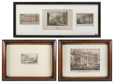
FIVE ARCHITECTURAL PRINTS OF HISTORIC NEW YORK AND LONDON BUILDINGS 19th CenturyEldred's4.7(409)See Sold PriceMar 07, 2024
Blackie (Pub) 1882 Folio Map. East Indies - Indian ArchipelagoAlbion Auctions4.6(336)See Sold PriceMar 01, 2024
Blackie (Pub) 1882 Folio Map. West India Islands & Central AmericaAlbion Auctions4.6(336)See Sold PriceMar 01, 2024
1792 OLD INDIA HISTORY ANTIQUE ILLUSTRATED WITH MAPS OF THE EIGHTEENTH CENTURY IN FRENCHNY Elizabeth 4.3(84)See Sold PriceMar 03, 2024
The Storming Monopoly Fort or the Directors [East India Company] in DismayIndigo Art AuctionsSee Sold PriceMar 08, 2024
2019 9-Coin 1/4 oz Gold Monarchs of the Empire Proof SetGolden Air Auctions4.4(257)See Sold PriceFeb 24, 2024


![The Storming Monopoly Fort or the Directors [East India Company] in Dismay (1 of 2)](https://p1.liveauctioneers.com/7876/320247/172091847_1_x.jpg?height=282&quality=70&version=1708450338)


