2 Illuminated Books of Hours LeavesSchmidt's Antiques Inc. Since 19114.8(431)See Sold PriceMar 02, 2024
Illuminated Manuscript Leaf of The CrucifixionSchmidt's Antiques Inc. Since 19114.8(431)See Sold PriceMar 02, 2024
RARE 1930s AUTOGRAPH BOOK FEATURING RUTH & GEHRIGJohn McInnis Auctioneers,LLC4.5(505)See Sold PriceFeb 25, 2024
Timetable, Paper and Ephemera Lot-Eastern USA RailroadsJM Hobby Supply and Railroad Artifact Auctions4.4(127)See Sold PriceFeb 24, 2024
SCARCE 1971 Kim Il Sung Signed Book "ON THE WORK OF THE WOMAN'S UNION"Rbfinearts4.5(578)See Sold PriceFeb 24, 2024
1885 CIVIL WAR 1ed Famous Memoirs US Grant Sheridan Sherman 6v RARE LOT MapsSchilb Antiquarian Rare Books4.8(428)See Sold PriceMar 10, 2024
"WINTER AND SUMMER IN MAINE" 1904 PHOTO ALBUMJohn McInnis Auctioneers,LLC4.5(505)See Sold PriceFeb 25, 2024
1821 THE (3) VOYAGES of CAPT JAMES COOK VOL. I-VIIJohn McInnis Auctioneers,LLC4.5(505)See Sold PriceFeb 24, 2024
[BASEBALL]. [SHEET MUSIC]. KALBFLEISCH, J. H. The Live Oak ...Potter & Potter Auctions4.6(545)See Sold PriceMar 07, 2024
Illuminated Manuscript Leaf of The VisitationSchmidt's Antiques Inc. Since 19114.8(431)See Sold PriceMar 02, 2024
Illuminated Manuscript Leaf of GethsemaneSchmidt's Antiques Inc. Since 19114.8(431)See Sold PriceMar 02, 2024
c1700s RARE Arabic Handwritten Manuscript Middle East Persia Journal ARABIASchilb Antiquarian Rare Books4.8(428)See Sold PriceMar 10, 2024
SoldNOVA BELGICA ET ANGLIA NOVANOVA BELGICA ET ANGLIA NOVAmap of the North American east coast by Willem Blaeu (1571-1663), after a manuscript map by Adriaen Block,, engraving with early coloring, 16-1/2 x 20-1/2 in. (sight), withSee Sold Price
Sold[Civil War] Shiloh Battlefield Map & Notes Manuscript document with hand-drawn map, illustration, and recollections of the Battle of Shiloh. 2 pages. A wonderful rendering of the Battle of Shiloh (Battle of Pittsburgh Landing) enhanced by illuSee Sold Price
SoldLarge lot of old letters and manuscripts American andLarge lot of old letters and manuscripts American and abroad - most 1st quarter of the 19th century thru 1900. Lot also includes 2 small 1 page hand drawn pen/ink maps (folded with tears on folded creSee Sold Price
Sold[Autographs & Manuscripts] Franklin, Benjamin, Signed[Autographs & Manuscripts] Franklin, Benjamin Signed Indenture Philadelphia: December 28th, 1722 (amended September 2, 1768). 1 p. 24 1/2 x 15 in. (62 x 38 cm). Indenture relating to yearly sums paidSee Sold Price
SoldLg Group Documents 1686-1762 Land Treaties 2 MapsLg Group Documents 1686-1762 Land Treaties 2 Maps, Large lot of historic documents primarily form the 18th century relating to the Easton Pennsylvania area, treaties with the Delaware Indians, and lanSee Sold Price
Sold2 Manuscript Volumes. Latin. [Ca late 1400s-1500s][Manuscripts] 2 Vols. Latin, laid paper. (nd). [Ca. late 1400’s – 1500’s.] One vol contains [10] leaves, the other volume [54] leaves only and has contemporary marginal notations in a differentSee Sold Price
Sold2 Maps: Early U.S. plus Louisiana and a Polar Map, 19thTwo framed maps, 19th century. One oak framed map of United States east of the Mississippi and Louisiana and one gilt wood framed map of the polar regions.(SBAR2375/2) {PR} Measurements: Oak frame isSee Sold Price
Sold2 Maps incl: Aestivarum Insulae... [ca 1680-1700].[Colonial US/Bermuda]. 2 Maps. ++ Aestivarum Insulae at Barmudas. Marks locations of 11 forts, with letters corresponding to a key at lower left. A derivative of John Speed’s map (of 1627), this marSee Sold Price
SoldEARLY MANUSCRIPT MAPS ACTUAL SURVEYSH/P LOT (3) EARLY MANUSCRIPT MAPS ACTUAL SURVEYS W/ SECTION LOT/PLOT SIGNED SAMUEL PRESTON-WM. SIMPSON, C. 1791, LARGEST 10" X 16"See Sold Price
SoldGrp: 2 Maps of Venice Chatelain MunsterGroup of two maps of Venice. Includes Henri Abraham Chatelain (1684-1743), "Carte de Geographie des Differents Etats de la Republique de Venise l'Abrege de son Gouvernement Politique et EccleSee Sold Price
Sold2 Maps of US - 18th century1st item: AMERIQUE SEPTENTRION LE DIVISEE EN SES PRINCIPAUX ETATS; A PARIS CHEZ DELAMARCHE GEO. 1783. French engraved and handcolored map of North America, with major American cities noted. 7 3/4" x 1See Sold Price
Sold2 Maps, incl: Map of the Northern & MIddle States[United States]. 2 Maps. ++ A Map Of The States Of Virginia, North Carolina, South Carolina And Georgia: Comprehending the Spanish Provinces of East and West Florida: Exhibiting the Boundaries as fixeSee Sold Price
Sold2 Maps of Spain2 Maps of Spain. 1). Ortelius (Abraham)-c ''Valentiae Regnieastern Spain''- showing Valencia, large ornamental cartouche and galleons in full sail, engraved map, ca. 1585. 13 3/4 x 19 1/2'' 2). BleauSee Sold Price
Sold2 Maps, 1858 Gillette Maps of Monroe Co. NY2 Maps, 1858 Gillette Maps of Monroe Co. NYSee Sold Price
Sold2 Manuscripts: Purchases & boarding house.[Financial Records]. 2 Manuscripts. Ledgers, 8vo, in contemp leather. Sold with all faults.++ Manuscript record, probably purchases made, Jan. 1858 – July 1862. Notes date, the person paid, and theSee Sold Price
SoldLot 2 books 2 maps Geology Colorado Rio GrandeLot of 2 books and 2 loose maps related to Geology: Ninth Annual Report of the United States Geological and Geographical Survey of the Territories embracing Colorado and Parts of Adjacent Territories�See Sold Price
Sold2 Maps incl: BOWLES’S NEW POCKET MAP... [ca. 1780][Atlantic/Maryland] 2 Maps. ++ BOWLES’S NEW POCKET MAP OF THE ATLANTIC OR WESTERN OCEAN, Laid down from the latest Discoveries, and Regulated by Numerous Astronomical Observations. Lon: Carington BoSee Sold Price
SoldAntique Maps: Turcic Imperii Imago, 2 Maps, oneDetailed map covering the Ottoman territories in the Balkans, Anatolia, Levant, Arabia and North Africa published by Henricus Hondius in Atlas sive Cosmographicae Meditationes de Fabrica Mundi et FabrSee Sold Price
Sold2 Maps incl: L’Empire de la Chine... [c. 1761-92][Asia/China/Indonesia]. 2 Maps. Later hand-colored outline.++ L’Empire de la Chine d’Apres l’Atlas Chinois, avec les Isles du Japon. Engraved by Lattre. From an edition of Bonne’s “Atlas ModSee Sold Price
Sold2 maps: L'Empire de la Chine + Index IVe. Feuille.[Asia/China/Indonesia]. 2 Maps. ++ L’Empire de la Chine d’Apres l’Atlas Chinois, avec les Isles du Japon. Engraved by Lattre. From an edition of Bonne’s “Atlas Moderne ou Collection de CarteSee Sold Price
SoldVarious. 2 maps of the West Indies. c.1740/1817.[Caribbean] 2 maps. (1) Homann Heirs. Dominia Anglorum in Praecipuis Insulis Americae ut sunt Insula S. Christophori Antegoa Iamaica Barbados nec non Insulae Bermudes vel Sommers. c.1740. Engraved mapSee Sold Price
Sold2 Maps: Stato Del Gran Turco + Asia Minoris.[De Rossi/Middle East] 2 Maps. ++ Stato Del Gran Turco diviso ne suoi Beglierbati, o Governi, e ne Principati, che li sono Tributari. Elaborate map of the Middle East, including Greece, Italy, the CasSee Sold Price
SoldRGS - Geographical Journal C1945 Lot 16 Manuscript MapsIncl Canada, Isle of Wight, Burma, Norway, Gough Island, Fiji, Tibet, Leeward Islands, South Africa, Antarctic, Uganda, Morocco, Canada, and Brazil. Lot of 16 Hand Drawn Manuscript (one is printed) AlSee Sold Price
Archaeological Books - Hilprecht - The Excavations in Assyria and BabyloniaTimeLine Auctions Ltd.4.6(183)See Sold PriceMar 06, 2024
Archaeological Books - Stillwell - The Princeton Encyclopedia of Classical SitesTimeLine Auctions Ltd.4.6(183)See Sold PriceMar 06, 2024
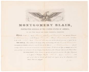
SOMERSET, Lord Charles (1767-1831) and BLAIR, Montgomery (1...Potter & Potter Auctions4.6(545)See Sold PriceMar 07, 2024
Willem Blaeu, Etc. 17th C. Antiquarian Maps, 2Auctions at Showplace4.6(740)See Sold PriceMar 17, 2024
1800 MUNGO PARK TRAVELS to AFRICA 2 VOLS w/ MAP antique in ENGLISHJasper524.5(9.9k)See Sold PriceFeb 27, 2024
1675 ELZEVIER JULIUS CAESAR antique ILLUSTRATED w/ MAPS ROMAN HISTORYJasper524.5(9.9k)See Sold PriceFeb 27, 2024
1738 BIBLE in DUTCH ILLUSTRATED w/ MAPS antique MASSIVE FOLIO BIBLIAJasper524.5(9.9k)See Sold PriceFeb 27, 2024
ANTIQUE ROMAN ARMORIAL VELLUM BINDING, 1744, ILLUSTRATED WITH AN ANTIQUE MAP BY FLORUSNY Elizabeth 4.2(86)See Sold PriceMar 03, 2024
OLD ILLUSTRATED 1902 CROSS-COVERED LANDS JOURNEY TO CALCUTTA, INDIA, 2 VOLUMESNY Elizabeth 4.2(86)See Sold PriceMar 03, 2024
ANTIQUE ILLUSTRATED HANDBOOK OF GEOGRAPHY AND TRAVEL IN ASIA, VOLUME 2, 1896NY Elizabeth 4.2(86)See Sold PriceMar 03, 2024
THE ANTIQUE ILLUSTRATED BOOK "1856 ARCTIC EXPLORATIONS: SECOND GIRNEL EXPEDITION 2" BY E. KANENY Elizabeth 4.2(86)See Sold PriceMar 03, 2024
THE WHOLE CHRONICLE OF POLYBIUS ANCIENT IN ENGLISH, 1756NY Elizabeth 4.2(86)See Sold PriceMar 03, 2024
ANTIQUE 1686 OPERA OMNIA BY JOHN LIGHTFOOT TELLIMA BOUND FOLIO WITH ISRAEL MAPNY Elizabeth 4.2(86)See Sold PriceMar 03, 2024
1792 OLD INDIA HISTORY ANTIQUE ILLUSTRATED WITH MAPS OF THE EIGHTEENTH CENTURY IN FRENCHNY Elizabeth 4.2(86)See Sold PriceMar 03, 2024


![[BASEBALL]. [SHEET MUSIC]. KALBFLEISCH, J. H. The Live Oak ... (1 of 5)](https://p1.liveauctioneers.com/928/318880/171361400_1_x.jpg?height=282&quality=70&version=1707501302)


![[Civil War] Shiloh Battlefield Map & Notes (1 of 2)](https://p1.liveauctioneers.com/7226/294713/156486525_1_x.jpg?height=282&quality=70&version=1688306668)

![[Autographs & Manuscripts] Franklin, Benjamin, Signed (1 of 1)](https://p1.liveauctioneers.com/65/168030/84729752_1_x.jpg?height=282&quality=70&version=1588715715)

![2 Manuscript Volumes. Latin. [Ca late 1400s-1500s] (1 of 6)](https://p1.liveauctioneers.com/179/76430/40094142_1_x.jpg?height=282&quality=70&version=1440006126)

![2 Maps incl: Aestivarum Insulae... [ca 1680-1700]. (1 of 4)](https://p1.liveauctioneers.com/179/49347/23134455_1_x.jpg?height=282&quality=70&version=1388425910)


![2 Maps incl: BOWLES’S NEW POCKET MAP... [ca. 1780] (1 of 8)](https://p1.liveauctioneers.com/179/72471/37352403_1_x.jpg?height=282&quality=70&version=1432244280)

![2 Maps incl: L’Empire de la Chine... [c. 1761-92] (1 of 8)](https://p1.liveauctioneers.com/179/47316/21802709_1_x.jpg?height=282&quality=70&version=1383851649)