Sold(2) Geographical, Statistical, and Historical Maps(2) Geographical, Statistical, and Historical Maps, of Massachusetts and New Hampshire, from Carey and Lea's American Atlas of 1823, sight size 20.5" x 16.5"See Sold Price
Geographical, Statistical and Historical Map of IndianaTitle/Content of Map: Geographical, Statistical and Historical Map of Indiana Date Printed: 1822 Cartographer: LUCAS FIELDING, JR. Size (inches): 17.25x22.2 "...Drawn by F. Lucas, Jr. Engraved by YounSee Sold Price
Geographical, Statistical, and Historical Map ofTitle/Content of Map: Geographical, Statistical, and Historical Map of Kentucky Date: 1822 Cartographer: LUCAS, FIELDING, JR. Size: 17.25X22.2 Plate no. 27 from their "Complete historical, chronologicSee Sold Price
SoldStatistical & Historical Map of New York 1827Map Title: Geographical, Statistical, and Historical Map of New York Date: 1827 Publisher: Carey & Lea: New York Size: 11.9 x 17.2 inches Shows counties, towns, townships, roads, topography, & more. SSee Sold Price
SoldCarey & Lea - Virginia, 1822Henry Charles Carey (1793-1879) and Isaac Lea (1792-1886) makers, Geographical, Statistical, and Historical Map of Virginia, 1822, engraving on wove paper with hand color, 13-3/4 x 19-1/2 in. (plate),See Sold Price
Sold[Washington, D.C.] Geographical, Statistical,[Washington, D.C.] Geographical, Statistical, And Historical Map Of The District Of Columbia. 10 1/2 square with large explanatory text in margins, Potomac River in original color. Minor offsetting, lSee Sold Price
SoldMap of Cuba and The Bahama Island''Geographical Statistical and Historical Map of Cuba and The Bahama Island''- hand-colored engraving by B. Tanner, some tears and stains, mounted to cardboard, top mat glued down. 16 1/2 x 20 1/4''See Sold Price
SoldMap of VirginiaGeographical, Statistical and Historical Map of Virginia, Engravers Young and Delleker. Center fold line evident. 16 1/4" H x 21 3/4" W, Frame 18 1/2" H x 22 1/2" WSee Sold Price
Leeward Islands Map C. 1823Geographical, Statistical and Historical Map of the Leeward Islands. 1823. Engraver: J. Yeagar. Publisher: Carey & Lea. Hand-colored. Condition: Some discoloration.; 17 1/2" x 22"See Sold Price
Sold(2) EARLY 1800'S MAPS OF DELAWAREIncludes: "Geographical, Historical, and Statistical Map of Delaware"; pencil writing identifies it as from Delaware - Carey and Lea, Philadelphia, 1822, (page 19); drawn by F. Lucas Jr., Engraved bySee Sold Price
SoldEngraved Map of AmericaYoung & Delleker, 1821, "Geographical, Historical, and Statistical Map of America" with engraved maps, original coloring, 17" x 21 1/2" sight size, 24" x 29 3/4" framed.See Sold Price
SoldCOLTON'S ATLAS OF THE WORLD, 2 LARGE CLOTH BOUNDVOLUMES, 19 1/4" X 17". PUBLISHED BY J. H. COLTON, NEW YORK, 1856. VOLUME ONE CONTAINS 63 PLATES WITH GEOGRAPHICAL, STATISTICAL AND HISTORICAL INFORMATION. THE OVERALL CONDITION IS GOOD WITH SOME FOXISee Sold Price
4 Maps (1838) North America, 2 Canada, West Indies[North America] 4 Maps from T. G. Bradford, “An Illustrated Atlas, Geographical, Statistical, And Historical, Of The United States, And Adjacent Countries,” Bos: Weeks, Jordan, and Company/ NY: WiSee Sold Price
Geographical Statistical & Historical Map of Peru, 1822Map: Geographical Statistical & Historical Map of Peru Maker: Carey & Lea, Finlayson, J. Publisher: Carey & Lea, Philadelphia 1822 Size: Double Folio – 13.60 H x 12.50 W Inches No. 50. Most conciseSee Sold Price
SoldGeographical, Statistical & Historical Map Canada, 1823Map: Geographical, Statistical and Historical Map of Upper and Lower Canada, and the other British Possessions in North America Cartographer: F. Lucas Publishing: Philadelphia / Baltimore, 1823 Size:See Sold Price
Geographical, Statistical, Historical Map of BrazilMap: Geographical, Statistical, Historical Map of Brazil Maker: Carey & Lea, Finlayson Date: 1825 Size: Double Folio, 11.6 inches high x 11.25 inches wide Only eleven states or territories. Most conciSee Sold Price
Geographical, Statistical & Historical Map Canada, 1826Map: Geographical, Statistical, and Historical Map of Upper and Lower Canada, and the Other British Possessions in North America Publishing: Carey & Lea, Lucas, Fielding, Jr. / Young & Delleker, sc.,See Sold Price
Geographical Statistical & Historical Map of Peru, 1828Map: Geographical, Statistical and Historical Map of Peru Maker: Carey & Lea, Finlayson, J. Publisher: Carey & Lea, Philadelphia 1828 Size: Quarto – 13.30 H x 12.50 W Inches From the third edition CSee Sold Price
SoldGeographical, Statistical & Historical Map of VT1825 Geographical, Statistical and Historical Map of Vermont published by Young and Dellecker, hand colored with Historical Sketch in surround. 18 x 22"See Sold Price
Geographical, Statistical, Historical Map of AmericaTitle/Content of Map: Geographical, Statistical, and Historical Map of America. Date Printed: 1820 Cartographer: FINDLAYSON, J./YOUNG & DELLEKER, sc. Size: 8.75X15.75 Maps of both North and South AmerSee Sold Price
Geographical, Statistical, & Historical Map of AmericaTitle/Content of Map: Geographical, Statistical, and Historical Map of America. Date Printed: 1820 Cartographer: FINDLAYSON, J./YOUNG & DELLEKER, sc. Size (inches): 10.3x10.6 Maps of both North and SoSee Sold Price
Sold1826 Geographical Map of Vermont1826 hand-colored Geographical, Statistical, & Historical map of Vermont, engraved by Young & Delleker, Carey & Lea atlas page, creased, unframed, 17 3/4" x 22 1/4"See Sold Price
1822 F Lucas Geographical, Statistical, & Historical1822 F Lucas Geographical, Statistical, & Historical Map of Vermont w/ letterpress text printed on the map, image 16.5” x 20.5”See Sold Price
SoldGeographical Statistical Historical Michigan Map, 1822Map: Geographical, Statistical and Historical Map of Michigan Territory Cartographer: Carey & Lea Publishing: Philadelphia, 1822 Size: 17 x 21.8 inches This is the first map only focused on Michigan TSee Sold Price
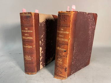
THE POPULAR AND CRITICAL BIBLE ENCYCLOPEDIA Scriptural Dictionary, 1901Neo FineArts Inc4.4(13)See Sold PriceFeb 25, 2024
[BUSINESS]. Travel Guide of Negro Hotels and Guest Houses. Published by Afro-American Newspapers ofFreeman's | Hindman4.4(1.6k)See Sold PriceFeb 27, 2024
1822 MAP of LEEWARD ISLANDS GEOGRAPHICAL STATISTICAL HISTORICAL antique 17.5x22"Jasper524.5(9.9k)See Sold PriceFeb 27, 2024
1822 MAP of SOUTH AMERICA GEOGRAPHICAL STATISTICAL HISTORICAL antique 17.5x 22"Jasper524.5(9.9k)See Sold PriceFeb 27, 2024
1858 INDIA HISTORY ILLUSTRATED antique Geographical, Statistical, and HistoricalJasper524.5(9.9k)See Sold PriceFeb 27, 2024
1822 MAP of NORTH & SOUTH AMERICA GEOGRAPHICAL STATISTICAL HISTORICAL antiqueJasper524.5(9.9k)See Sold PriceFeb 27, 2024
1822 MAP of CHILI GEOGRAPHICAL STATISTICAL HISTORICAL antique 17.5x 22" CHILEJasper524.5(9.9k)See Sold PriceFeb 27, 2024
Ireland.- Smedley (Edward) Erin. A Georgraphical and Descriptive Poem, 2 parts in 1, first edition,Forum Auctions4.3(53)See Sold PriceFeb 29, 2024
Geographical, Statistical, and Historical Map of the Leeward Islands.Jasper524.5(9.9k)See Sold PriceFeb 27, 2024
Geographical Statistical and Historical Map of the Windward IslandsJasper524.5(9.9k)See Sold PriceFeb 27, 2024
Geographical, Statistical, and Historical Map of the West Indies.Jasper524.5(9.9k)See Sold PriceFeb 27, 2024
Guthrie, William 1812 Antique Map. Spain and PortugalAlbion Auctions4.7(341)See Sold PriceMar 01, 2024
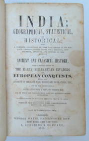
1792 OLD INDIA HISTORY ANTIQUE ILLUSTRATED WITH MAPS OF THE EIGHTEENTH CENTURY IN FRENCHNY Elizabeth 4.2(86)See Sold PriceMar 03, 2024
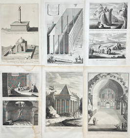
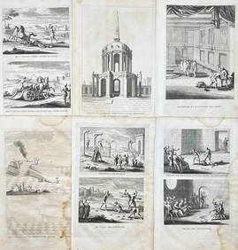
Antoine Augustin Calmet (1672-1757) - Set of 6 Religious Engravings - Tomb of Zechariah - Grotto ofProverde Auctions4.3(3)See Sold PriceFeb 28, 2024
Antoine Augustin Calmet (1672-1757) - Set of 6 Jewish Engravings - Tomb monument of the kings ofProverde Auctions4.3(3)See Sold PriceFeb 28, 2024
Antoine Augustin Calmet (1672-1757) - Set of 6 Architecture Engraving - Temple of Jerusalem -Proverde Auctions4.3(3)See Sold PriceFeb 28, 2024


![[Washington, D.C.] Geographical, Statistical, (1 of 1)](https://p1.liveauctioneers.com/179/1435/617546_1_x.jpg?height=282&quality=70)


![[BUSINESS]. Travel Guide of Negro Hotels and Guest Houses. Published by Afro-American Newspapers of (1 of 4)](https://p1.liveauctioneers.com/197/319238/171467937_1_x.jpg?height=282&quality=70&version=1707520367)