Sold2 Antique Framed Maps (Denmark & Saxony)Dania Regnvm, Denmark map circa 1650, colored (frame: 22.5" x 27.5" paper sight: 23.75" x 19.5) and Leonard Valk & Gerardi Circulus Saxoniae Inferioris divifa in Ducatus Brunsuici Zellae…. (frame: 2See Sold Price
SoldLOT OF THREE ANTIQUE c.1819 FRAMED MAPSLOT OF THREE ANTIQUE c.1819 FRAMED MAPS - EAST INDIES, DENMARK, SWEDEN, & NORWAY Height: 16 1/2 & 8 in. by Width: 18 1/2 & 10 in.See Sold Price
SoldTwo Scandinavian mapsTwo 19th century Scandinavian Maps, hand colored lithographs. Entitled "Denmark" and "Sweden and Norway" by J. Harrison, Philadelphia. Some toning. Images 9 1/2 x 11 1/4", framed 11 1/2 x 14 1/2" overSee Sold Price
Sold(2) ANTIQUE FRAMED MAPSAntique world map approximately 16" x 9.75" w/ frame and Asia minor 11.75" x 9.25" w/ frame.See Sold Price
Sold2 antique framed Southern maps2 antique framed maps: Map of South Carolina in German dated 1845. Map of Savannah and Charleston published by G.W and C.B Colton & Co and dated 1855. Overall size measures 25 1/2"h x 28"w and the papSee Sold Price
Sold2 Framed antique maps2 Framed antique maps, probably from an old atlas, British America & The United States, map drawn & engraved by J. Rapkin, illustrations by H. Warren & illustrations by R. Wallis, Maps are 10" x 13",See Sold Price
Sold2 FRAMED ENGR. MAPS OF SWEDEN, DENMARK, + NORWAY 13.5"2 FRAMED ENGR. MAPS OF SWEDEN, DENMARK, + NORWAY 13.5" X 14.75", + AMSTERDAM 1544, 11" X 14"See Sold Price
Sold(2) Framed Antique Maps, Goshen and Caln Township(2) Framed 19th Century Antique Maps showing local Townships. "East & West Goshen" map from Witmer's Atlas 1873, detailing West Chester and Goshen land owners and businesses. (14.75 x 14.75 inches) "CSee Sold Price
Sold22 1/2" X 19 1/2" ANTIQUE FRAMED SAMPLER CIRCA 172022 1/2" X 19 1/2" ANTIQUE FRAMED SAMPLER CIRCA 1720 MAP OF ENGLAND AND WALES - MINIMAL STAINING - MINIMAL WEARSee Sold Price
SoldSet of 2 Framed Prints of Antique MapsSet of 2 Framed Antique Maps - Small map of England and Scotland. Large Map of the Mediterranean with ships. Measures approx. Large map 28" tall x 31" w x 1" deep. Small map 12" tall x 15" w x 3/4" deSee Sold Price
Sold(2) FRAMED ANTIQUE ETCHINGS MAPS OF ARMENTIERES(lot of 2) Framed antique etchings on paper, Armentieres, France, including: (1) plan of the city of Armentieres, sight: 18.75"h, 22.5"w, overall: approx 25"h, 28.5"w, (1) map of Armentiers, label verSee Sold Price
Sold2 Framed Antique Engraved Maps Africa & AmericaTwo (2) Framed Antique Engraved Maps. One of Africa and the other America. Signed David Anglu 1680 ? Repairs or else Good Condition. Frames Measure 12-1/2 Inches by 15-1/2 Inches. Shipping $31.00 (estSee Sold Price
Sold(2 Pc) Framed Antique Celestial Map EngravingsDESCRIPTION: A lot of two antique celestial copperplate engravings from the series Harmonia Macrocosmica by Andreas Cellarius. The first "Sitvus Circvlis Cirvn Terra Coelestibvs Data" Engraved by JohaSee Sold Price
SoldHAND COLORED ENGRAVED MAPS ANTIQUE 2HAND COLORED ENGRAVED MAPS, ANTIQUE, 2:Framed. Date of printings unknown.See Sold Price
SoldTWO 1835 CONSTELLATION MAPS2 framed antique constellation hand colored maps circa 1835 by DFJ Huntington of Hartford CT, printed by WG Evans of NY - Plate V and Plate VI Northern Circumpolar. Each 14.5 x 13.5 image, framed 19 xSee Sold Price
SoldLot of 2 antique maps of FranceLot of 2 antique maps of France. Framed sizes are 21"h x 20"w and 20 1/2"h x 22"w, sight sizes are 14"h x 13"w and 13 1/4"h x 14 3/4"wSee Sold Price
Sold(2) EARLY MAPS FRANCE & DENMARK(lot of 2) Framed maps, comprising: (1) "A New Map of the Kingdom of Denmark Comprehending North and South Jutland, Zeeland, Fyen, Laaland and Part of Holstein" by John Cary, 1801, published by John CSee Sold Price
Sold(2) ANTIQUE MAPS, MOSES PITT 1681, EDW WELLS 1701(lot of 2) Antique maps, including: (1) Moses Pitt's (English, c.1639-1697), "The English Atlas, Vol 1" map of southeastern Denmark, including the islands of Lolland and Falster, hand colored, London,See Sold Price
SoldTwo Antique Framed Map Engravings1) Edinburgh, engraved by E. Turrell, and 2) St. Petersburg, engraved by B.R. Davies. [Overall framed size: 14 x 16 3/4 inches]. In good condition; age toning.See Sold Price
SoldThree Antique Framed Map Engravings1) Munich, engraved by T. Bradley; 2) Dresden, engraved by W. Henshall, and 3) Berlin, engraved by J. Henshall. [Overall framed size: 14 x 16 3/4 inches]. In good condition; age toning.See Sold Price
SoldThree Antique Framed Map Engravings1) Florence, engraved by E. Turrell; 2) Milan, engraved by J. Henshall, and 3) Madrid, engraved by J. Henshall. [Overall framed size: 14 x 16 3/4 inches]. In good condition; age toning.See Sold Price
Antique Framed Map of Fire Island, New York, 1902Map: Fire Island & Oak Island, New York, 1902 (Framed) Medium: Lithograph Dimensions: 42.5" L x 2" W x 19" H Display in a wood frame and UV protectant glass Publishing: Original engraving published bySee Sold Price
SoldAntique Framed MapAntique Framed Map "Carte des Parties Nord & Ouest de L'Amerique par M. De Vangondy 1772" {Dimensions of frame 18 1/2 x 22 1/2 inches}See Sold Price
17TH C. ANTIQUE MAP SIEGE OF LA ROCHELLE, FRANCE, FRAMEDThomaston Place Auction Galleries4.4(386)See Sold PriceFeb 24, 2024
18TH C. ANTIQUE MAP: FRENCH & INDIAN WAR, FRAMEDThomaston Place Auction Galleries4.4(386)See Sold PriceFeb 24, 2024
1937 Holland, Michigan, Tulip Time Map Guide, FramedLakeshore Event Center4.5(99)See Sold PriceMar 02, 2024
Antique Dresden Framed Cabinet Plate"Cavalier And AWorld of Antiques, Inc.3.9(74)See Sold PriceFeb 29, 2024
Two (2) Antique 18th C. Copper Engraved Framed Maps - America & EuropeMagnusson Art Group4.5(46)See Sold PriceMar 14, 2024
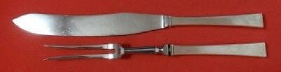
Bell by Hans Hansen Danish Denmark Sterling Silver Roast Carving Set 2pcMynt Auctions4.6(680)See Sold PriceFeb 28, 2024
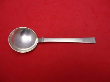
Bell by Hans Hansen Danish Denmark Sterling Silver Cream Soup Spoon 6 1/2"Mynt Auctions4.6(680)See Sold PriceMar 02, 2024
Cooke, George 1801 Antique Map. Sweden, Denmark, Norway, IcelandAlbion Auctions4.6(336)See Sold PriceMar 01, 2024
Map of the Count of Flanders, 1700 by Gillaume de Lisle, ParisAntiques Online Auctions4.6(407)See Sold PriceMar 14, 2024
Map of Turkey from Arabic and Persia, 1701 by Gillaume de Lisle, ParisAntiques Online Auctions4.6(407)See Sold PriceMar 14, 2024
Map of United States of North America, 1785Antiques Online Auctions4.6(407)See Sold PriceMar 14, 2024
Antique Map of Poland, 1700 by Guillaume De Lisle, ParisAntiques Online Auctions4.6(407)See Sold PriceMar 14, 2024
The Kingdom of Dalmatia Territories Map, 1700Antiques Online Auctions4.6(407)See Sold PriceMar 14, 2024
Antique Map of France, 1703 by Gillaume Del Isle PrintAntiques Online Auctions4.6(407)See Sold PriceMar 14, 2024