Sold*CONDET ANTIQUE MAP ENGRAVINGCondet (18th C. European School), "La Pologne", 2-sheet antique hand-colored map engraving, approximately 19 1/2" x 24", with frame 23" x 27 1/2".See Sold Price
SoldThree European Hand-Colored MapsThree Antique European Hand-Colored Maps , 18th c., incl.: "The Countie and Citie of Lyncolne Described with the Armes...", 15 in. x 20 in.; "Istria olim Iapidia", 15 in. x 19 1/2 in.; and "PrincipatuSee Sold Price
SoldTwo 18th Century French Made European MapsTwo 18th century French made map prints, framed. "Carte Des Isles Britanniques" 23" x 30" map of the British Islands made in Paris by C.F. Delamarche, and 23" x 28 1/2" 1702 French West Coast map. SomSee Sold Price
SoldFour 17th-18th C. Maps: Desing, Manesson-MallettCollection of four 17th and 18th European maps, Item 1: P. A. Desings map of the western hemisphere. Hand colored copper engraving published in 1741. 6 3/8" H x 5 3/4" W. Items 2 and 3: Two Manesson-See Sold Price
SoldEnglish 18th C. Petit Point Map of England & WalesDated May 8th 1787 or 1788. Framed and under glass. Sight: 21 x 18. Frame: 25 1/4 x 22 1/2 inches. Shipping weight: 5 lbs.See Sold Price
Sold18th century Bowen map of Carolinas,[A New & Accurate Map of the Provinces of North & South Carolina, Georgia, & C.,] Emanuel Bowen (1720-1767), "Country of the Cherokees" shown extending to Louisiana, 16 x 18-1/2 in.; modern wood frameSee Sold Price
SoldAntique French Map of St. AugustineAntique French Map of St. Augustine, "Plan de la Ville et Port de St. Augustin", late 18th/early 19th c., hand-colored engraved map, sight 8 1/2 in. x 12 in., framed. Provenance: Estate of Faith K. TiSee Sold Price
Sold(2) 18TH C. MAPSNetherlands. Dimensions: (Frame) H 32.25" x W 36", (Sight) H 22.5" x W 27" Condition: Wear consistent with age and handling. Toning, marks, and creases.See Sold Price
Sold[2] 18th C. Maps by D'Anville del Sig. Rollin[2] 18th C. Maps by D'Anville del Sig. Rollin. One of Romana, one of La Spagna. size: 12.5x9.5, 9.75x13.5See Sold Price
(2) 18th C. European School Paintings of Women(2) 18th C. European School Paintings of Women Holding Baskets of Fruit. Oil on canvas. Appears to be unsigned. Appears to have been re-lined. Sight size: 25 x 18.5 in.See Sold Price
SoldSILVER. 2 Pieces. 18th C. European SilverBox together with a Vienna Silver & Crystal Jug. Box - approx. 8 troy oz. From a Brooklyn, NY location. Dimensions: jug - 5.5" high x 5.5" wide, box - 5.5" wide x 2.75" deep x 3.75" high.See Sold Price
Sold2 ANTIQUE 18TH c EUROPEAN PEWTER CHARGERS1- Antique Large Early Continental Pewter Deep Dish Charger. 14 1/2". 2- 17th c. Continental Pewter Broad Rimmed Dish 12 1/2". Weight on all 4 pds 12 oz PROVENANCE: A Private Charleston SC EstateSee Sold Price
Sold(2) 18TH C ENGRAVED MAPS - 'Hollandia Comitatus' by(2) 18TH C ENGRAVED MAPS - 'Hollandia Comitatus' by Willem Janszoon Blaeu (1571-1638), Amsterdam, circa 1635. The upper right corner inset with map of the isles Texel, Vlieland and Terschelling; PLUSSee Sold Price
SoldEuropean School, (2) engravings, 18th c.European School, (2) engravings, 18th c., European School (18th c.), Incl. Antoine Jean Duclos, after Augustin de Saint-Aubin, (French, 18th c.), "Le Concert"; and, George Bickham (British, 18th c.),See Sold Price
Sold(2) FRAMED EARLY PRINTSLot of (2) 18th and 19th c. European Prints, incl: "Summer" hand colored engraving depicting field workers, after a drawing by Thomas Hearne (UK, 1744-1817), engraved by W. Ellis, in a gilded wooden fSee Sold Price
Sold18th c. Map of America- Emanuel Bowen18th c. Map- ''A New and Accurate Map of America''- engraved map, 1748, from John Harris- ''Complete Collection of Voyages and Travels'', short repaired separation at top of centerfold. 14 3/8 x 17 5/See Sold Price
SoldEMANUEL BOWEN 18TH C. MAP"Particular Draughts and Plans of some of the Principle Towns and Harbours Belonging to the English, French and Spanish in America and the West Indies," London, 1747 Engraving with hand-coloring (framSee Sold Price
Sold18th C. British Map - Triangular Trade - Thomas BowenThomas Bowen. A New & Accurate Chart of the Western or Atlantic Ocean Drawn from the Most Approved Modern Maps Etc. By Thos. Bowen 1788. Engraved for Thomas Bankes's New System of Geography. PublishedSee Sold Price
Sold*UNKNOWN ARTIST(Late 18th C. European School) 2 framed oils on canvas mounted/glued to masonite panel, still lifes with pear and grapes, neither bears signature, approximate image size of each 15" x 18", frames 18 1See Sold Price
Antique European Map Spain & Portugal, 18th CAntique European Map Spain & Portugal. Matted dimensions ca 30x24 plate 27. 18th century Please note that this lot has a confidential reserve. When you leave a bid in advance of the auction, submit yoSee Sold Price
Sold(2) 1799 G. Washington Obit. & 18th C. Dutch MapTo include The Providence Journal and Town and country Advertiser, December 25, 1799, recording the death of George Washington, 4 pages, pages 2 and 3, within a mourning border, 19" H x 12" W. Also anSee Sold Price
Sold18th C. Map of LouisianaAn 18th C. hand-colored engraved map by Emanuel Bowen, titled "A New and Accurate Map of Louisiana with Part of Florida and Canada, and the Adjacent Countries", Plate 59. Likely from the "Complete AtlSee Sold Price
Sold5 17th/18th c. European pottery tiles5 17th/18th c. European pottery tiles- 2 Italian tin-glazed earthenware floor tiles, 4 x 4''; 2 Spanish wall tiles- Bird and Swan, 2 3/4 x 2 3/4''; Spanish wall tile- Floral Spray, 5 1/2 x 5 1/2''; chSee Sold Price
SoldThree Antique New Orleans MapsThree Antique New Orleans Maps, 18th c., incl. 2 from Bellin's Petit Atlas Maritime and one published by London Magazine, sights 7 1/2 in. x 9 in. to 8 1/2 in. x 11 3/4 in., framed alikeSee Sold Price
EARLY 18TH C. MAP OF ITALY, FRAMEDThomaston Place Auction Galleries4.4(393)See Sold PriceFeb 24, 2024
18TH C. ANTIQUE MAP: FRENCH & INDIAN WAR, FRAMEDThomaston Place Auction Galleries4.4(393)See Sold PriceFeb 24, 2024
Willem Blaeu, Etc. 17th C. Antiquarian Maps, 2Auctions at Showplace4.6(740)See Sold PriceMar 17, 2024
Two (2) Antique 18th C. Copper Engraved Framed Maps - America & EuropeMagnusson Art Group4.5(53)See Sold PriceMar 14, 2024
Map: An 18thC engraved and hand coloured map of Northamptonshire, with description ofClaydon Auctioneers Ltd4.3(125)See Sold PriceFeb 26, 2024
Map: An 18thC engraved and hand coloured map of North America and South America, titled DeClaydon Auctioneers Ltd4.3(125)See Sold PriceFeb 26, 2024
Map: An 18thC engraved map of Bedfordshire titled An Accurate Map of the County of Bedford DividedClaydon Auctioneers Ltd4.3(125)See Sold PriceFeb 26, 2024
1758 MAP PARTIE DE LA MER GLACIALE contenants La Nouvelle Zemble RUSSIA antiqueJasper524.5(9.9k)See Sold PriceFeb 27, 2024
ANTIQUE 18TH C ENGLISH MALE PORTRAIT OIL PAINTINGAntique Arena Inc.4.5(878)See Sold PriceMar 02, 2024
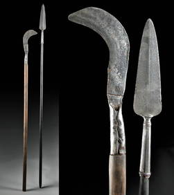
18th C. European Iron Polearms - Spear + BillhookArtemis Fine Arts4.8(1.4k)See Sold PriceFeb 26, 2024
ANTIQUE ROMAN ARMORIAL VELLUM BINDING, 1744, ILLUSTRATED WITH AN ANTIQUE MAP BY FLORUSNY Elizabeth 4.2(86)See Sold PriceMar 03, 2024
THE WHOLE CHRONICLE OF POLYBIUS ANCIENT IN ENGLISH, 1756NY Elizabeth 4.2(86)See Sold PriceMar 03, 2024
ANTIQUE 18TH C FEMALE PORTRAIT WATERCOLOR PAINTINGAntique Arena Inc.4.5(878)See Sold PriceMar 09, 2024
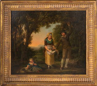
18th/19th C European Oil on Canvas PaintingAntiques Online Auctions4.6(415)See Sold PriceMar 14, 2024
18th/19th C European Oil on Canvas PaintingAntiques Online Auctions4.6(415)See Sold PriceMar 14, 2024
18th/19th C European Oil on Copper or Metal PaintingAntiques Online Auctions4.6(415)See Sold PriceMar 14, 2024
17th C, Italian St Peter Oil on Canvas PaintingAntiques Online Auctions4.6(415)See Sold PriceMar 14, 2024
18th/19th C European Oil on Metal Religious PaintingAntiques Online Auctions4.6(415)See Sold PriceMar 14, 2024
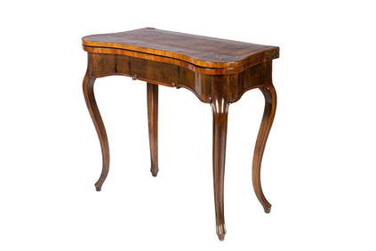
18th C NORTHERN EUROPEAN MIXED WOOD GAMES TABLEA.H. Wilkens Auctions & Appraisals4.7(396)See Sold PriceFeb 28, 2024
19TH CENTURY MEDICAL WORKS. A group of European medical works:Bonhams4.1(320)See Sold PriceJun 18, 2024


![[2] 18th C. Maps by D'Anville del Sig. Rollin (1 of 13)](https://p1.liveauctioneers.com/3627/179840/92339963_1_x.jpg?height=282&quality=70&version=1604662439)