Sold(2) 18TH C ENGRAVED MAPS - 'Hollandia Comitatus' by(2) 18TH C ENGRAVED MAPS - 'Hollandia Comitatus' by Willem Janszoon Blaeu (1571-1638), Amsterdam, circa 1635. The upper right corner inset with map of the isles Texel, Vlieland and Terschelling; PLUSSee Sold Price
(2) 18TH C ENGRAVED MAPS - 'Hollandia Comitatus' by(2) 18TH C ENGRAVED MAPS - 'Hollandia Comitatus' by Willem Janszoon Blaeu (1571-1638), Amsterdam, circa 1635. The upper right corner inset with map of the isles Texel, Vlieland and Terschelling; PLUSSee Sold Price
Sold(2) 18TH C ENGRAVED MAPS - "Neue Welt-Karte welche auf(2) 18TH C ENGRAVED MAPS - "Neue Welt-Karte welche auf zwoo Kugelflaechen die Haupt Theile der Erde . . . enthält". Homann Erben, Nürnberg. 1784. 19" x 22 3/4", vertical center fold; PLUS "EuropSee Sold Price
Sold(2) 18th C Double-page, hand-colored maps(2) 18th C Double-page, hand-colored etched and engraved maps taken from an atlas, inc the Champagne region of France and Antwerp, largest 16-1/2" x 20-1/2" pl, very good conditionSee Sold Price
*UNKNOWN ARTIST(Mid 18th C. French) 2-sheet engraved map front piece and log introducing plates from larger folio, 1761 pencil date notation, approximate plate size 15" x 21 1/2", total paper size 20" x 26".See Sold Price
Sold3 18th C. Engraved Maps of FranceLot of three engraved maps of France, 20 1/4"h x 24 1/2"w (largest). Creases and toning.See Sold Price
Sold18th C. Engraved Map of "Anglesey"18th century, engraved map of "Anglesey", by John Speed, 15 1/2"h x 20 1/2"w (sight).See Sold Price
Sold18th C. Engraved Map of "Denbighshire"18th century, engraved map of "Denbighshire", by John Speed, 15 1/2"h x 20 1/2"w (sight). Losses along left edge.See Sold Price
SoldMap: An 18thC engraved map of Buckinghamshire afterMap: An 18thC engraved map of Buckinghamshire after Pieter Van den Keere (1571-c. 1646). Approx. 3 1/2" x 4 3/4"See Sold Price
Sold*ZATTA, ANTONIO(18th C. Italian) Handcolored engraved map illustrating Maryland, Jersey, Delaware, Virginia and Carolina settlements, approximate plate size 13 1/4" x 17 1/2", frame 16" x 22 1/2".See Sold Price
*UNKNOWN ARTIST(Mid 18th C.) "Tableau Chronologique", 2-piece engraved handcolored map, 1761 date hand notation lower right, approximate plate size 15" x 21", total sheet size 20" x 26".See Sold Price
SoldBlaeu map of western Holland.Heading: Author: Blaeu, Willem Title: Hollandia Comitatus Place Published: Amsterdam Publisher: Date Published: c.1640 Description: Copper-engraved map, hand-colored. 39x52See Sold Price
SoldSet of six color engraved European mapsSet of six color engraved European maps, mid 18th c., 8 1/2" x 12 1/2".See Sold Price
Sold18th C hnd colored copper plate engraved map of No18th C hnd colored copper plate engraved map of North America by Thomas Bowen - image size 10 1/2 x 17See Sold Price
SoldAntique French Map of St. AugustineAntique French Map of St. Augustine, "Plan de la Ville et Port de St. Augustin", late 18th/early 19th c., hand-colored engraved map, sight 8 1/2 in. x 12 in., framed. Provenance: Estate of Faith K. TiSee Sold Price
Sold18th c. Map- Buckinghamshire18th c. hand-colored map- ''Buckingham/ Ensis Comitatus/ Anglis/ Buckingham Shire''- hand colored engraving, fair condition. 16 1/2 x 10 1/2''See Sold Price
Engraved map of Germany, 18th c., 19'' x 22 1/2''.Engraved map of Germany, 18th c., 19'' x 22 1/2''.See Sold Price
SoldThree early engraved European maps, 18th c., twoThree early engraved European maps, 18th c., two depicting Bohemia, the other Silesiae, largest - 19'' x 22 1/2''.See Sold Price
SoldBurgandy France Antique MapComitatus Burgundiae. Hand-colored engraved map. French wine region. J.B. Homann, Nuremberg, 18th C. 24 3/4" x 21".See Sold Price
SoldBleau map: Hollandia Comitatus, c.1631[Netherlands]. William Bleau. Hollandia Comitatus. Double-page map engraved by Joshua van den Ende. Amst: c.1631. 15 1/8 x 18 3/4 in. Shields of 32 cities featured on lower border, decorated cartoucheSee Sold Price
SoldEngraved map of Britain, 18th/19th c., 14 1/2'' xEngraved map of Britain, 18th/19th c., 14 1/2'' x 18 1/4''.See Sold Price
Sold2 maps of Korea & Japan: 18th C. Hand-colored.[Korea & Japan/Asia]. 2 engraved double-page maps. Very good condition. ++ Homann Heirs after d'Anville. Et Des Rojaumes De Coree Et De Iapan. Machuria, Korea, Japan, and Sakhalin Island, c.1749. FullSee Sold Price
SoldRichard W Seale, engraved handcolored "Map of AncientRichard W Seale, engraved handcolored "Map of Ancient Egypt", sheet 10 1/2"x 8 3/4", mid 18th c, unframedSee Sold Price
Sold*LEWIS, SAMUEL(18th C. American) "The Province of Maine", framed engraved map, having artist name and date of "1794" on plate upper left, approximately 15" x 10 1/2", with frame 22" x 17 1/2".See Sold Price
ARMOR MUSEUM LEVEL TURKISH STYLE WARRIOR HELMET ANNULET ARABIC 2 SILVER AXEHISTORY Collections.4.2(16)See Sold PriceFeb 28, 2024
18TH C. ENGLISH PEWTER PLATES & PLATTERS BY ROBERT NICHOLSONThomaston Place Auction Galleries4.4(393)See Sold PriceFeb 24, 2024
EARLY 18TH C. MAP OF ITALY, FRAMEDThomaston Place Auction Galleries4.4(393)See Sold PriceFeb 24, 2024
18TH C. ANTIQUE MAP: FRENCH & INDIAN WAR, FRAMEDThomaston Place Auction Galleries4.4(393)See Sold PriceFeb 24, 2024
18TH C. GILT ALTAR FIGURE OF BODHISATTVAThomaston Place Auction Galleries4.4(393)See Sold PriceFeb 24, 2024
Two (2) Antique 18th C. Copper Engraved Framed Maps - America & EuropeMagnusson Art Group4.5(53)See Sold PriceMar 14, 2024
Map: An 18thC engraved and hand coloured map of Buckinghamshire after Robert Morden. Approx. 8 1/4"Claydon Auctioneers Ltd4.3(125)See Sold PriceFeb 26, 2024
Map: An 18thC engraved and hand coloured map of Northamptonshire, with description ofClaydon Auctioneers Ltd4.3(125)See Sold PriceFeb 26, 2024
Map: An 18thC engraved and hand coloured map of North America and South America, titled DeClaydon Auctioneers Ltd4.3(125)See Sold PriceFeb 26, 2024
Map: An 18thC engraved map of Bedfordshire titled An Accurate Map of the County of Bedford DividedClaydon Auctioneers Ltd4.3(125)See Sold PriceFeb 26, 2024
Map: An 18thC engraved map titled A New and Improved Map of Oxfordshire.. after Thomas Kitchin.Claydon Auctioneers Ltd4.3(125)See Sold PriceFeb 26, 2024
1816 MAP SOUTHERN PART OF RUSSIA or MUSCOVY in EUROPE copper engraving ANTIQUEJasper524.5(9.9k)See Sold PriceFeb 27, 2024
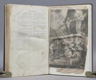
1744 ROMAN HISTORY ARMORIAL VELLUM BINDING ILLUSTRATED w/ MAP antique by FLORUSJasper524.5(9.9k)See Sold PriceFeb 27, 2024
1758 MAP PARTIE DE LA MER GLACIALE contenants La Nouvelle Zemble RUSSIA antiqueJasper524.5(9.9k)See Sold PriceFeb 27, 2024
1675 ELZEVIER JULIUS CAESAR antique ILLUSTRATED w/ MAPS ROMAN HISTORYJasper524.5(9.9k)See Sold PriceFeb 27, 2024
1798 BIBLE FIRST HOT PRESS EDITION LARGE FOLIO antique AMERICANA 18th cent. RAREJasper524.5(9.9k)See Sold PriceFeb 27, 2024
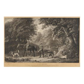
after George Stubbs (English, 1724-1806), Game KeepersLeland Little4.5(701)See Sold PriceFeb 29, 2024
ANTIQUE ROMAN ARMORIAL VELLUM BINDING, 1744, ILLUSTRATED WITH AN ANTIQUE MAP BY FLORUSNY Elizabeth 4.2(86)See Sold PriceMar 03, 2024