SoldA Framed 19th Century Map of Florida, Height of printA Framed 19th Century Map of Florida, circa 1855, lithography printing by Bowne & Hasbrouck, New York, titled "U.S. Coast Survey...Sketch F... with a General Reconaissance of the Coast of Florida 1848See Sold Price
SoldFour Washington D.C. Related Maps & Prints ca. 19th CenturyGroup of four Washington D.C. related maps & prints, ca. mid to late 19th century. Frame size of "Map of Washington. District of Columbia." are 10 1/2" H x 11 1/2" W x 3/8" D.See Sold Price
SoldPrints and Maps.Great Lot of 19th century and earlier Prints and Maps. includes Colton 1857 Map of Greece, Hand Colored Plates, Steel Engravings and others. Great GroupSee Sold Price
Sold19C Oak Map Print Paper Collector's Case CabinetUnited States,Late 19th Century Six long drawers with bin pulls on a molded base, used for holding works on paper including maps and blueprints. Oak 57" x 36" x 32", From an Exeter, Rhode Island estatSee Sold Price
Sold1600s View of Mexico Hand Colored Map PrintNot sure when this was printed, but probably 18th or early 19th century. It has been in its current for about 100 years. Image size is 9 x 10.5, but is larger with border. Framed to 12.75 x 14.75. ImaSee Sold Price
SoldFRAMED LATE 19TH CENTURY MAP OF FLORIDAA photo print of the state of Florida published by George F. Cram of Chicago, Ilinois. Dates from between 1885 and 1905, as it includes the Florida East Coast Railway to Miami, but not the Overseas RaSee Sold Price
SoldCase Tiffany & Co, Map Of The United States, 1851American, mid 19th century. "Map of the United States", c. 1851, lithograph with color on banknote paper, published by Case Tiffany & Co (American, founded 1836). A map of the United States (includingSee Sold Price
SoldMap and Print AssortmentMap and Print Assortment Approximately (12) pounds of 17th-19th century engravings, etchings and mezzotints, some hand-colored, by various artists including Phillipe de la Rue, Edward Rooker, and AdriSee Sold Price
Sold1835 EXQUISITE French ATLAS Cartography MAPS Navigation1835 EXQUISITE French ATLAS Cartography MAPS Navigation Voyages Illustrated Monin Charles V. Monin was a 19th-century French cartographer who was one of the first Europeans to print maps under the priSee Sold Price
Sold1833 ATLAS MAPS Cartography Navigation Voyages1833 ATLAS MAPS Cartography Navigation Voyages Illustrated French Petit Monin Charles V. Monin was a 19th-century French cartographer who was one of the first Europeans to print maps under the printinSee Sold Price
1835 ATLAS MAPS Cartography Navigation Voyages1835 ATLAS MAPS Cartography Navigation Voyages Illustrated Monin French Petit Charles V. Monin was a 19th-century French cartographer who was one of the first Europeans to print maps under the printinSee Sold Price
Sold1835 ATLAS MAPS Cartography Navigation Voyages Illustra1835 ATLAS MAPS Cartography Navigation Voyages Illustrated Monin French Petit Charles V. Monin was a 19th-century French cartographer who was one of the first Europeans to print maps under the printinSee Sold Price
Sold4 19th Century Michigan Pocket MapsIncludes the following titles: Map of Osceola Township and Vicinity Houghton Co. Michigan, published by R.M. Edwards, Calumet, Mich. 1892, 10.75 x 12.5 inches, colored folded in print card stock boardSee Sold Price
SoldA Group of Antique Prints and Maps18th and 19th centuries, subjects include animals, French maps, architecture, classical and anthropological. Dimensions: From 9 1/2" x 8 1/2" to 14" x 10".See Sold Price
Sold19th Century Historical Nantucket Map 1869Historical Nantucket map with information, points, and references for the 17th, 18th, and 19th Century. Surveyed and drawn by The Reverend F. C. Ewer, D.D., this piece is a J. Ottmann Of New York LithSee Sold Price
Sold19C Oak Map Blueprint Ephemera Collector's CaseUnited States,Late 19th Century Squat five drawer cabinet, used for holding maps or blue prints. Oak 46" x 35" x 15 1/2", From an Exeter, Rhode Island estate.See Sold Price
Sold6pc John Gould 6 Full Color Prints "Hummingbirds"6 Pieces of John Gould "Hummingbirds". Portfolio of six color prints by 19th Century Ornithologist Artist, John Gould. Published and copyright, 1946 by I.B. Fischer Co, New York City. Very good conditSee Sold Price
SoldVintage Map, William Eddy/Alex Zakreski, AWilliam Eddy (American, 19th century), "A Topographical & Complete Map of San Francisco Compiled from the Original Map from the Recent Surveys of W.M. Eddy County Surveyor and Others, Containing all tSee Sold Price
SoldLot with ten Cartes De Visite, one tin type rebelLot with ten Cartes De Visite, one tin type rebel soldiers, two pieces with rebel soldiers, two Yankee soldiers, two 19th century bullets, print of Grant 1892 Boston map, and group of 19th century recSee Sold Price
Sold(6pc) ANTIQUE FRENCH LANDSCAPE PRINTS18th & 19th Centuries, colored engravings and lithographs depicting various French landmarks, nicely framed by the Old Print Shop (labels on back) with French matting overall: 21 x 26 in. (largest)See Sold Price
SoldEuropean Prints, inc. Paris MapFive (5) 19th-20th Century European prints including Rossingol's Plan of Paris map. 1st item: Copper plate engraving with hand coloring reproduction of "Icy e[s]t le vray pourtraict de la ville, cite,See Sold Price
SoldHand-colored map, Chester, EnglandFramed hand-colored lithograph map, ""Chester, England,"" British School, 19th century, signed ""J.M. Gahey"" within print lower left, overall: 31""h x 40""wSee Sold Price
SoldAN ANTIQUE MAP, "Maps of the new and popular St. LouisAN ANTIQUE MAP, "Maps of the new and popular St. Louis and Texas Short Line!," LATE 19TH CENTURY, color lithograph on paper, with inset, "Map of the Saint Louis Iron Mountain and Southern Railway anSee Sold Price
Two 19th C. Japanese PrintsLot of two 19th century Japanese prints, depicting one continuous image of map with calligraphy, 59" h x 27 1/2" w. Provenance: From a California estate.See Sold Price
Pre-colonial Africa. Mountains of Kong/Moon. Caravan routes. THOMSON 1817 mapJasper524.5(9.9k)See Sold PriceFeb 28, 2024
COLONIES FRANÇAISES en AFRIQUE. Africa Sénégal Madagascar. LEVASSEUR c1850 mapJasper524.5(9.9k)See Sold PriceFeb 28, 2024
Johnson's Africa. Colonies & tribes. Liberia Nile Delta Cape Colony 1866 mapJasper524.5(9.9k)See Sold PriceFeb 28, 2024
NUBIA. 'Nubie'. Nile Valley. Sudan Ethiopia Egypt. MALLET 1683 old antique mapJasper524.5(9.9k)See Sold PriceFeb 28, 2024
West Africa. Sahara caravan routes. Tribes Kingdoms Empires. LIZARS 1842 mapJasper524.5(9.9k)See Sold PriceFeb 28, 2024
Afrique Ancienne. Ancient North Africa. MALTE-BRUN c1871 old antique map chartJasper524.5(9.9k)See Sold PriceFeb 28, 2024
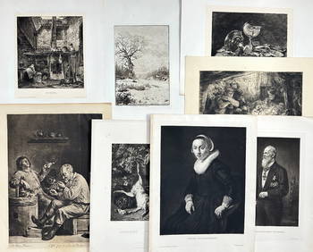
Lot of 12 Portraits - Emmanuel Pérès de Lagesse - Anton Van Dyck - George Howland BeaumontProverde Auctions4.3(3)See Sold PriceFeb 28, 2024
Lot of 16 Portraits - Raphael - Michael Stecher Walther - Peder Oxe - Albrecht, archduke of AustriaProverde Auctions4.3(3)See Sold PriceFeb 28, 2024
Lot of 30 Portraits - Johannes Nikolaus Tetens - Jacob de Witt - Georg Christoph Lichtenberg -Proverde Auctions4.3(3)See Sold PriceFeb 28, 2024
Lot of 30 Portraits - Adolph Hendrik - Cornelis van Aerssen - Peder Hanson Resen - Jacob van derProverde Auctions4.3(3)See Sold PriceFeb 28, 2024
Set of 8 Antique Prints - Wilhelm Hecht - ??Junge Holländerin?? - after David Teniers II - 19thProverde Auctions4.3(3)See Sold PriceFeb 28, 2024
Jules de Liron d’Airoles (1802 - 1882) - Antique Fruit Print of Pond's Seedling PlumProverde Auctions4.3(3)See Sold PriceFeb 28, 2024
Joseph Meyer - Set of 12 Prints - Prag - Czech Republic - Germany - Buchberg - Nachod - JohannisbergProverde Auctions4.3(3)See Sold PriceFeb 28, 2024
Joseph Meyer - Set of 50 Prints - Views of Austria - Germany - Italy - Sweden - France - CzechProverde Auctions4.3(3)See Sold PriceFeb 28, 2024
Joseph Meyer - Set of 50 Prints - Views of Austria - Germany - Italy - Sweden - France - UnitedProverde Auctions4.3(3)See Sold PriceFeb 28, 2024
Joseph Meyer - Set of 20 Prints - Views of Austria - Germany - Italy - Torino - PisaProverde Auctions4.3(3)See Sold PriceFeb 28, 2024
Joseph Meyer - Set of 20 Prints - Views of Austria - Germany - Italy - Switzerland - France - SpainProverde Auctions4.3(3)See Sold PriceFeb 28, 2024
Ludwig Erminy - Topography in Bulgaria - Ruins of Orava - Danube Views: BulgariaProverde Auctions4.3(3)See Sold PriceFeb 28, 2024
Louis Kolitz - Antique Drawing - Portrait of a WomanProverde Auctions4.3(3)See Sold PriceFeb 28, 2024
Louis Kolitz - Antique Drawing - Side portrait of a WomanProverde Auctions4.3(3)See Sold PriceFeb 28, 2024
Louis Kolitz - Antique Drawing - Portrait of a Young WomanProverde Auctions4.3(3)See Sold PriceFeb 28, 2024