19th c. Schoolgirl map of British Isles
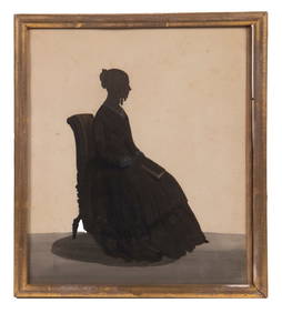
MID 19TH C. BRITISH SILHOUETTEFeb 24, 2024LATE 17TH C. FRENCH MAP OF THE NEW WORLD BY ALEXIS-HUBERT JAILLOT (1632-1712)Feb 24, 2024Rare 19thc Colton Map of Sweden And NorwayFeb 24, 2024GROUPING OF (19th c) BRITISH SATIRICAL PRINTS etcFeb 24, 202419thc J. H. Colton Map of Holland And BelgiumMar 02, 202419th C. Joseph Rodgers & Sons British Cutlery SetMar 02, 202419th C British Hand Painted Paper Mache TraysMar 02, 2024Huge British School 19th C Nautical Maritime Coastal Boats Monogrammed OilFeb 25, 2024AN ANTIQUE FOLDING MAP OF THE BRITISH ISLES DATED 1873Feb 28, 2024Chatelain - 3 Maps of the British Isles (England, Ireland, Scotland)Feb 24, 2024De Jode, Rare, pub. 1593 - Map of the British Isles [England, Scotland, Ireland] (Angliae Scotiae etFeb 24, 2024Map: A 17thC engraved map of the British Isles titled A Generall Mapp of the Isles of GreatFeb 26, 2024Map: A 19thC engraved and hand coloured map of Buckingham titled A New Map of BuckinghamshireFeb 26, 2024British School, 19th c. Off the British Coast, oilMar 02, 2024Pitch Pine Barrel Front Hanging Corner CupboardMar 04, 2024Mahogany Chinese Chippendale Game TableMar 04, 2024Early Jacobean Oak Gate Leg Drop LeafMar 04, 2024Edwardian Flame Mahogany Corner CabinetMar 04, 2024Stanford, Edward 1901 Large Map. Geological Map of the British IslesMar 01, 2024Stanford, Edward 1901 Large Map. Hydrographical Map of the British IslesMar 01, 2024Stanford, Edward 1901 Large Map. Stereographical Map of The British IslesMar 01, 2024Rare 19thc Colton Map, Argentine Republic, Chile, Uruguay, PataguayMar 16, 202419th C. Map of South Texas and Gulf CoastFeb 24, 2024BRITISH SCHOOL (19th C)Feb 28, 2024 


![De Jode, Rare, pub. 1593 - Map of the British Isles [England, Scotland, Ireland] (Angliae Scotiae et (1 of 2)](https://p1.liveauctioneers.com/6581/319571/171593327_1_x.jpg?height=282&quality=70&version=1707853304)


![[Ogilby (John)] Road from London to Barwick (1 of 1)](https://p1.liveauctioneers.com/410/8611/1592488_1_x.jpg?height=282&quality=70)