Sold19th C. Map of North & South CarolinaEach county individually hand colored; unframed; 14 1/2"W, 12"H; small tears to margins well outside border and map, toningSee Sold Price
SoldFour 19th century maps, Southeast"North America, Sheet XII, Georgia with parts of North & South Carolina, Tennessee, Alabama & Florida", by J. & C. Walker, from [Maps of the Society for the Diffusion of Useful Knowledge. Vol. 1,] pubSee Sold Price
19thc Atlas Map, Georgia, South Carolina19th Century Rand, McNally & Co.'s New 11" X 14" Map of Georgia, copyright 1895 on one side, South Carolina map on the reverse. Pages 29 & 30 from an original atlas book.See Sold Price
19thc Atlas Map, Georgia, South Carolina19th Century Rand, McNally & Co.'s New 11" X 14" Map of Georgia, copyright 1895 on one side, South Carolina map on the reverse. Pages 29 & 30 from an original atlas book.See Sold Price
SoldTwo Colored Engravingsearly scene of Philadelphia, and hand-colored 19th c. map of North and South America. Each framed under glass. Philadelphia, 4" high, 5 3/4" wide; Map, 10" high, 13 1/2" wide.See Sold Price
SoldLate 19th Century Map of North and South CarolinaLate 19th Century Map of North and South Carolinafrom the People's Cyclopedia of Universal Knowledge (New York: Phillips & Hunt, 1882). Behind mat in gilt wooden frame. DOA 16 x 17.75 in. Estate ColleSee Sold Price
SoldC. 1856 Atlas Map of North & South CarolinaPublished by A. & C. Black, Edinburgh; Printed in Colours by Schenck & Macfarlane, Edinburgh; Drawn & Engraved by John Bartholomew, Edinburgh; matted and under glass in black painted frame; sight 15 3See Sold Price
Sold19th C SOUTH CAROLINA MAP - JOHN LETHEMFramed 19th c. New Railroad and County Map of South Carolina that was prepared for Industries and Resources South, published by John Lethem, Publisher, Charleston SC in 1884. Henry Stebbins was the enSee Sold Price
SoldThree Maps of the Southeastern UnitedStates, American or British, 18th and 19th century: "A New Map of North & South Carolina, & Georgia", by Thomas Kitchin, from the [London Magazine,] April 1765, showing the Carolinas, Georgia, and porSee Sold Price
Sold19th C. Mitchells Map of Florida19th C. Mitchells map of Florida counties, and South Carolina county map. Entered into congress 1860. 11.75"H. x 13.75" image size, French mat and gilt frame. 18.25"H. x 22.25" overall.See Sold Price
Sold19th Century Map of the Carolinas19th Century Map of the Carolinas"Johnson's North and South Carolina," (New York: Johnson & Ward, ca. 1860s), hand colored steel engraving from folio, fine details showing the major roads and railroadSee Sold Price
Sold(2) JOHN TALLIS ATLAS MAPS NORTH & SOUTH AMERICA(lot of 2) Framed hand-colored engravings on paper, maps of North and South America, mid 19th c., published in John Tallis's "Illustrated Atlas," drawn and engraved by John Rapkin, with illustrated viSee Sold Price
SoldSeven 19th C. Maps of U.S. StatesLot of seven 19th C. maps of various U.S. states, including Connecticut, Missouri, South Carolina, Alabama, Iowa, Arizona/New Mexico, Minnesota. Various dates and publishers.See Sold Price
SoldNorth and South Carolina mapNorth and South Carolina map 18th/19th centuryhand drawn detailing Carolina river system, framed.sight size: H8 1/4" W13 1/4"See Sold Price
SoldAmerica.- Bowen (Emanuel) A New & Accurate Map of theAmerica.- Bowen (Emanuel) A New & Accurate Map of the Provinces of North & South Carolina Georgia &c., detailed map showing the region from Chesapeake Bay to St. Augustine, Florida and west to PensacoSee Sold Price
SoldSamuel Lewis Map of South CarolinaEarly 19th C. hand-colored map by Samuel Lewis, engraved by Henry Schenck Tanner. With minor foxing and discoloration, not examined out of frame / in as-found condition.Visible image: approx. 11" x 8See Sold Price
Sold19th Century Map of the Carolinas[Map of North & South Carolina], by H.S. Tanner, from Tanner's [New American Atlas...], Philadelphia, 1823, demarcated counties, key listing forts, battlegrounds, other points of interest, "American ASee Sold Price
SoldRare 1967 Mouzon Map of North & South Carolinavery limited production by Louis and Clark Explorer Maps LLC in Kitty Hawk, and Charlotte, North Carolina. reproduction gives excellent detail and very well resembles the original map. marked "L&C" atSee Sold Price
Early 19th C. Map and Storia Della Scoperta D'AmericaEarly 19th C. Map and Storia Della Scoperta D'America fatta Da Christoforo Colombo, being a map of North and South American and showing the voyage of Christoper Columbus , surrounded by a descriptionSee Sold Price
Two Revolutionary War MapsAmerican, early 19th century: "A Map of those parts of Virginia, North Carolina, South Carolina, & Georgia, which were the scenes of most important Operations of the Southern Armies", engraved by ShalSee Sold Price
Sold18th c. Purcell Map, "State of Franklin"Joseph Purcell: A MAP OF THE STATES OF VIRGINIA, NORTH CAROLINA, SOUTH CAROLINA, AND GEORGIA; Comprehending the SPANISH PROVINCES of EAST AND WEST FLORIDA. Scarce Edinburgh, Scotland imprint, circa 17See Sold Price
SoldMap, Johnson's North and South Carolinathird quarter 19th century, insets of Charleston, French Broad River, and Table Mountain (Table Rock, NC). Presented behind mat in dark wooden frame. 25.75 x 32 in. Additional high-resolution photosSee Sold Price
Sold19th century map of the Southeast,"A Map of those parts of Virginia, North Carolina, South Carolina, and Georgia, which were the scenes of the most important Operations of the Southern Armies", by Francis Shallus, plate VIII of [The LSee Sold Price
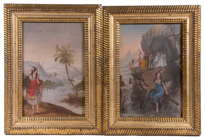
PR OF NAIVE 19TH C AMERICAN ALLEGORICAL MINIATURE PAINTINGSThomaston Place Auction Galleries4.4(393)See Sold PriceFeb 24, 2024
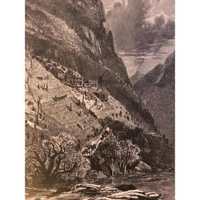
19thc North Carolina Engraving, Farm On The French Broad RiverConnoisseur Auctions3.9(336)See Sold PriceMar 02, 2024
Continental School, "Portrait of a Boy," 19th c., H.- 20 in., W.- 16 1/8 in., Framed- H.- 26 1/4Crescent City Auction Gallery4.3(231)See Sold PriceMar 01, 2024
Carey, pub. 1796 - Map of the Tennassee State formerly part of North Carolina (Tennessee)Trillium Antique Prints & Rare Books4.5(32)See Sold PriceFeb 24, 2024
Map: A 19thC engraved and hand coloured map of South America. Published by the Society for theClaydon Auctioneers Ltd4.3(125)See Sold PriceFeb 26, 2024
Map: A 19thC engraved map of West Riding, titled A Map of the North Part of the West Riding ofClaydon Auctioneers Ltd4.3(125)See Sold PriceFeb 26, 2024
1822 MAP of NORTH & SOUTH AMERICA GEOGRAPHICAL STATISTICAL HISTORICAL antiqueJasper524.5(9.9k)See Sold PriceFeb 27, 2024
Blackie (Pub) 1882 Pair of Folio Maps. Italy - North & SouthAlbion Auctions4.6(341)See Sold PriceMar 01, 2024
Rare 19thc Colton Map, Argentine Republic, Chile, Uruguay, PataguayConnoisseur Auctions3.9(336)See Sold PriceMar 16, 2024
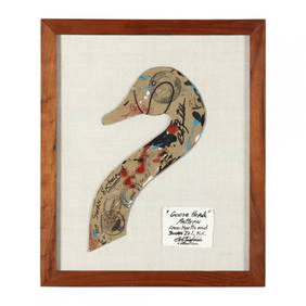
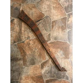
Rare 19thc Native American Indian Gunstock War ClubConnoisseur Auctions3.9(336)See Sold PriceMar 16, 2024
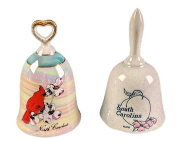
Vintage North And South Carolina Souvenir Porcelain BellsRapid Estate Liquidators and Auction Gallery4.5(1.1k)See Sold PriceMar 02, 2024