Sold1943 FORTUNE WORLD ISLAND MAP OF ALLIES AND AXISOutlines Axis and Allies during 1943, 21 x 26.75 inches, shows mild wear and tear around edges.See Sold Price
World War 2. Nov 1943-Dec 1944. Gilbert Islands. Pacific landings & Ops 1959 mapTITLE/CONTENT OF MAP: 'The War with Japan - Landings in the Gilbert Islands, 21 November 1943 and Operations in the Central and Southwest Pacific Areas, January-December 1944' DATE PRINTED: 1959 IMAGESee Sold Price
LESSER ANTILLES. Windward & Leeward islands. Puerto Rico. Trinidad 1944 mapTITLE/CONTENT OF MAP: 'Lesser Antilles; Inset Puerto Rico; Trinidad' This map was printed in an atlas that was published during the Second World War. Many of the maps show the advance of the Axis poweSee Sold Price
Sold1940's-50's National Geographic Society MapsIncludes "The World Map, 1943," "Theater of Ware in Europe, 1942," "South America, 1942," "Southwestern U.S., 1940," "Europe Near East, 1943," "Asia, 1942," "Africa, 1943," "Pacific Ocean, 1943," "MapSee Sold Price
SoldWorld Map from 1943 WWII by Alcoa Aluminum1943 Alcoa Aluminum Polar Projection of the World during World War II. Global Map for Global War and Global Peace. Size: 24.4 x 33 in. In house shipping is available, buyer pays shipping cost.See Sold Price
SoldWorld Map from 1943 WWII by Alcoa Aluminum1943 Alcoa Aluminum Polar Projection of the World during World War II. Global Map for Global War and Global Peace. Size: 24.4 x 33 in. In house shipping is available, buyer pays shipping cost.See Sold Price
World Map from 1943 WWII by Alcoa Aluminum1943 Alcoa Aluminum Polar Projection of the World during World War II. Global Map for Global War and Global Peace. Size: 24.4 x 33 in. In house shipping is available, buyer pays shipping cost.See Sold Price
SoldLarge WW2 Photo Album- Bomb FactoryDozens of photos, excellent content. Condition as shown. [World War 2, World War 1,Allies, Nazi, Axis, Allies]See Sold Price
SoldSanson (Nicolas) Les Deux Poles Arcticque ou SepteSanson (Nicolas) Les Deux Poles Arcticque ou Septentrional, et Antarcticque ou Meridional,double-hemisphere world map on its polar axis, with allegorical figure groups of the four elements inSee Sold Price
SoldWW1/WW2 Era Bayonet ScabbardCondition as shown. [World War 2, World War 1,Allies, Nazi, Axis, Allies]See Sold Price
WW2 US Canteen w/ ClothCondition as shown. [World War 2, World War 1,Allies, Nazi, Axis, Allies]See Sold Price
SoldWW2 Air Force Jacket & MedalsCondition as shown. [World War 2, World War 1,Allies, Nazi, Axis, Allies]See Sold Price
Sold1910 M1 Long Pack w/ Blanket & Shovel1910 M1 Long Pack with Blanket and T-handled shovel. [World War 2, World War 1,Allies, Nazi, Axis, Allies]See Sold Price
SoldSam Brown BeltCondition as shown. [World War 2, World War 1,Allies, Nazi, Axis, Allies]See Sold Price
SoldNamed WW2 Era Canteen w/ ClothCondition as shown. [World War 2, World War 1,Allies, Nazi, Axis, Allies]See Sold Price
Sold755th Tank Battalion Photo- Clemson ShirtCondition as shown. [World War 2, World War 1,Allies, Nazi, Axis, Allies]See Sold Price
SoldWW2 Assorted Badges/InsigniaLot of 5. Condition as shown. [World War 2, World War 1,Allies, Nazi, Axis, Allies]See Sold Price
Korean War Era Folding ShovelCondition as shown. [World War 2, World War 1,Allies, Nazi, Axis, Allies]See Sold Price
Naval Shirt with rankCondition as shown. [World War 2, World War 1,Allies, Nazi, Axis, Allies]See Sold Price
SoldOkinawa Island Map: Air Traffic Control Patterns inWorld War II Okinawa Island Map: Air Traffic Control Patterns in Advance of Japanese Mainland Invasion Map showing air traffic control patterns over the southwestern part of OkinawaSee Sold Price
A Set of Treasure and Discovery Island Brochures.Van Eaton Galleries4.6(99)See Sold PriceMar 02, 2024
1834 Malte-Brun Map of the Caribbean -- West India IslandsJasper524.5(9.8k)See Sold PriceFeb 27, 2024
World War 2 Europe Battle of the Atlantic 1939-43 Axis Expansion limits 1959 mapJasper524.5(9.8k)See Sold PriceFeb 28, 2024
Operation Torch Nov 1942-May 1943. World War 2. Western Mediterranean 1966 mapJasper524.5(9.8k)See Sold PriceFeb 28, 2024
Blackie (Pub) 1882 Folio Map. West India Islands & Central AmericaAlbion Auctions4.6(336)See Sold PriceMar 01, 2024
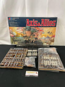
Axis & Allies World War II Strategy Board Game, Factory Sealed & extra game piecesCrawford Family Auctions LLC4.5(112)See Sold PriceMay 25, 2024