MATTHEWS c1856 Map Of Upper Canada Ontario Indian Land Agency Divisions Scarce!Luis Porretta Fine Arts4.3(10)See Sold PriceMar 02, 2024
DEVINE c1856 Dr Salters Map Of Lake Huron Ontario Indian Lands etc. No. 7 ScarceLuis Porretta Fine Arts4.3(10)See Sold PriceMar 02, 2024
DUNLEVIE c1856 Map Counties Of Gaspe & Bonaventure Quebec Canada SCARCE! #1Luis Porretta Fine Arts4.3(10)See Sold PriceMar 02, 2024
DUNLEVIE c1856 Map Counties Of Gaspe & Bonaventure Quebec Canada SCARCE! #2Luis Porretta Fine Arts4.3(10)See Sold PriceMar 02, 2024
Map UNITED COUNTIES LEEDS & GRENVILLE by Walling 1861 Rare Canada Map 5ft x 5ftLuis Porretta Fine Arts4.3(10)See Sold PriceMar 02, 2024
Ambroise TARDIEU c1822 Map Venice Napoleon Italian Campaign 17" x 11"Luis Porretta Fine Arts4.3(10)See Sold PriceMar 02, 2024
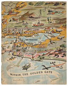
Sold1905 Rand McNally Map of San Francisco -- San FranciscoTitle/Content of Map: 1905 Rand McNally Map of San Francisco -- San Francisco Date Printed: 1905, Chicago Cartographer: Rand McNally Size: 26 x 19 in. This is a large, magnificient map of San FranciscSee Sold Price
1905 Rand McNally Map of San Francisco -- San FranciscoTitle/Content of Map: 1905 Rand McNally Map of San Francisco -- San Francisco Date Printed: 1905, Chicago Cartographer: Rand McNally Size: 26 x 19 in. This is a large, magnificient map of San FranciscSee Sold Price
1905 Rand McNally Map of San FranciscoTitle/Content of Map: 1905 Rand McNally Map of San Francisco -- San Francisco Date Printed: 1905, Chicago Cartographer: Rand McNally Size: 26 x 19 in. This is a large, magnificient map of San FranciscSee Sold Price
1898 Rand McNally Map of San FranciscoTitle/Content of Map: 1898 Rand McNally Map of San Francisco Date: 1905, Chicago Cartographer: Rand McNally Size: 13.5 x 11 in. A very nice map od San Francisco from the late 19th century. The map comSee Sold Price
Sold1898 Rand McNally Map of San FranciscoTitle/Content of Map: 1898 Rand McNally Map of San Francisco Date: 1905, Chicago Cartographer: Rand McNally Size: 13.5 x 11 in. A very nice map od San Francisco from the late 19th century. The map comSee Sold Price
1898 Rand McNally Map of San FranciscoTitle/Content of Map: 1898 Rand McNally Map of San Francisco Date: 1905, Chicago Cartographer: Rand McNally Size: 13.5 x 11 in. A very nice map od San Francisco from the late 19th century. The map comSee Sold Price
Rand McNally: Antique Map of San Francisco, 1898Title/Content of Map: 1898 Rand McNally Map of San Francisco Date Printed: 1905, Chicago Cartographer: Rand McNally Size: 13.5 x 11 in. A very nice map od San Francisco from the late 19th century. TheSee Sold Price
SoldRand McNally: Map of San Francisco, 1911Map: 1911 Rand McNally Map of San Francisco -- San Francisco Cartographer: Rand McNally Year/Place: 1911, Chicago Dimensions: 26 X 19 in. A very nice map of central San Francisco with an inset of theSee Sold Price
Rand McNally: Antique Map of San Francisco, 1895Map: 1895 Rand McNally Map of San Francisco and [verso] California Cartographer: Rand McNally Year / Place: 1895, Chicago Map Dimensions: 11.4 x 9.4 in. Condition: Map very good overall. Colored. VirtSee Sold Price
Rand McNally: Vintage Map of San Francisco, 1940Title: Rand McNally Indexed Reference Map of San Francisco San Francisco City Map Series Map maker: Rand McNally & Co. Place and Year: Chicago, 1940 Dimensions: 78.7 x 76.2 cm (31 x 30 in) Technique:See Sold Price
Rand McNally: Antique Map of San Francisco, CaliforniaTitle/Content of Map: 1910 McNally Map of San Francisco and California -- Main portion of San Francisco [verso]California Date Printed: 1910, Chicago Cartographer: Rand, McNally Size: 12.5 9.3 in. A vSee Sold Price
SoldRand McNally & Company Map of San FranciscoRand McNally & Company Map of San Francisco From Atlas Of The World. Sight: 13 1/4 x 11 inches. (Framed, not examined out of the frame)See Sold Price
1895 Rand McNally Map of California and San FranciscoTitle/Content of Map: 1895 Rand McNally Map of California and [verso] San Francisco -- California [verso] Map of the Main Portion of San Francisco Date Printed: 1895, Chicago Cartographer: Rand McNallSee Sold Price
SoldSan Francisco 1896Title/Content of Map: San Francisco 1896 Date Printed: 1896 Material/Medium: paper Size: approx. 11x 13.5 inches Rand McNally & Co. Universal Atlas of the World Reserve: $20.00 Shipping: Domestic: FlSee Sold Price
San Francisco 1900Title/Content of Map: San Francisco 1900 Date Printed: 1900 Material/Medium: Paper Size: 11x14 inches Rand McNally prepared for The Public Ledger, Philadelphia Reserve: $30.00 Shipping: Domestic: FlaSee Sold Price
SoldColor map of San Francisco 1911Heading: (California - San Francisco) Author: Title: Map of San Francisco and Vicinity Place Published: [n.p.] Publisher:Rand McNally & Co. Date Published: 1911 Description:See Sold Price
1895 Map of San FranciscoAuthor: McNally Title: 1895 Map of San Francisco Medium: Ink on Paper Dimensions: 11"X14" Map of San Francisco, dated 1895. Engraved and published by Rand McNally in Chicago. Part of Mc Nally World AtSee Sold Price
1910 McNally Map of San Francisco and California --Title/Content of Map: 1910 McNally Map of San Francisco and California -- Main portion of San Francisco [verso] California Date: 1910, Chicago Cartographer: Rand, McNally Size: 12.5 x 9.3 in. A very nSee Sold Price
Sold1910 McNally Map of San Francisco and California --Title/Content of Map: 1910 McNally Map of San Francisco and California -- Main portion of San Francisco [verso] California Date: 1910, Chicago Cartographer: Rand, McNallySize: 12.5 x 9.3 in. A very niSee Sold Price
1910 McNally Map of San Francisco and California --Title/Content of Map: 1910 McNally Map of San Francisco and California -- Main portion of San Francisco [verso] California Date: 1910, Chicago Cartographer: Rand, McNally Size: 12.5 x 9.3 in. A very nSee Sold Price
SoldPromotional map of South San Francisco c.1890Heading: Author: South San Francisco Land & Improvement Co. Title: South San Francisco. Issued By The South San Francisco Land & Improvement Co. Place Published: Chicago Publisher:Rand, McNally & Co.See Sold Price
SoldMap of Bay Area ports and facilitiesHeading: (California - San Francisco Bay Area) Author: Rand, McNally & Co. Title: Ports and Facilities on San Francisco Bay, and Tributary Waters Place Published: San Francisco Publisher: Date PuSee Sold Price
San Francisco 1900Title: San Francisco 1900 Date Printed: 1900 Cartographer: Material/Medium: Paper Size: 11x14 inches Additional Information: Rand McNally prepared for The Public Ledger, Philadelphia Reserve: $30.00See Sold Price
1895 Rand McNally Map of California & San FranciscoTitle/Content of Map: 1895 Rand McNally Map of California and [verso] San Francisco1895, Chicago Cartographer: Rand McNally Size: 11.4 x 9.4 in. An excellent map of California and on reverse, San FranSee Sold Price
Chicago Milwaukee and St Paul RY Panama Pacific Exposition Brochure-1915JM Hobby Supply and Railroad Artifact Auctions4.4(126)See Sold PriceFeb 24, 2024