Sold1874 ATLAS OF ONTARIO CO. NY MAPS.1874 OF ATLAS ONTARIO CO. NY MAPS. 83 PGS HAND COLORED MAPS. INCLUDES STATE MAP, OUTLINE PLAN, DISTANCE TABLE, POST OFFICES, POPULATIONS, EXPLANATIONS. PUBLISHED BY POMEROY, WHITMAN & CO. PHILADELPHIASee Sold Price
Sold1864 ATLAS OF JEFFERSON CO. NY MAPS BEERS, STONE.1864 ATLAS OF JEFFERSON CO. NY MAPS BEERS, STONE. 41 HAND COLORED MAPS INCL. ILLUS. OF HUNGERFORD COLLEGIATE INSTITUTE, BUSIN. DIRECTORY, BROOKSIDE CEMETERY, STATISTICS, ETC. TITLE: NEW TOPOGRAPHICALSee Sold Price
SoldLOT (16+) ASSORTED 19TH CENTURY MAPS,LOT (16+) ASSORTED 19TH CENTURY MAPS, WESTCHESTER/KINGS, CO. NYSee Sold Price
Sold1874 ATLAS OF SENECA CO. NY BY POMEROY, MAPS.1874 ATLAS OF SENECA CO. NY BY POMEROY, MAPS. 45 PGS HAND COLORED MAPS INCL. BUSIN. DIRECTORIES, EXPLANATIONS, POPULATION, POST OFFICES, ETC. PUBLISHED BY POMEROY, WHITMAN & CO, PHIL. 1874. ORIG. HARDSee Sold Price
Sold2 Maps, 1858 Gillette Maps of Monroe Co. NY2 Maps, 1858 Gillette Maps of Monroe Co. NYSee Sold Price
Sold1829 David Burr Clinton County, NY map1829 David Burr Clinton County, NY map, Rawdon Clark & Co., Albany & Rawdon Wright & Co., NY hand colored, earliest known printed map of Clinton County, plate size 17 3/4" x 20", sheet size 24" x 21 1See Sold Price
Sold1868 ATLAS HERKIMER CO NY STRANAHAN BEACH NICHOLS.1868 ATLAS HERKIMER CO NY STRANAHAN BEACH NICHOLS. 32 PAGES OF HAND COLORED MAPS. INCL. TABLE OF DISTANCES, STATE MAP, ETC. PUBLISHED BY STRANAHAN, BEACH & NICHOLS, NY. A FEW PGS HAVE TAPED AREAS, SOMSee Sold Price
Sold1872 ATLAS OF MONROE CO. NY BY F.W. BEERS CO.1872 ATLAS OF MONROE CO. NY BY F.W. BEERS CO. 115 HAND COLORED PAGES OF MAPS INCL. BUSINESS DIRECTORIES. ALSO INCL: TOWN PLANS, VILLAGE PLANS, TABLE OF DISTANCES, STATISTICS, OUTLINE MAPS, POPUL. OF MSee Sold Price
SoldSloane. LIFE OF NAPOLEON BONAPARTE. 4 Vols. 1896.[Napoleon] William Milligan Sloane. LIFE OF NAPOLEON BONAPARTE. 4 Vols. NY: Century Co., 1896. Ink inscription on Vol I’s ffep: “Rene Jacques/ Presented by the employees at Clark-Hutchinson-CompanSee Sold Price
SoldMap of Ontario, Rand, McNally & Co. 1898Map: Ontario Rand, McNally & Co. 1898 New Standard Atlas of the World 28 x 21.5 inches Please note that this lot has a confidential reserve. When you leave a bid in advance of the auction, submit yourSee Sold Price
Sold19th Century Atlas.Atlas titled "Olney's School Atlas", published by Pratt, Woodford, & Co., NY, 1844. Paper wraps. Book measures 12" x 9.75" and contains hand-colored maps. Interior exhibits some staining and off-settiSee Sold Price
SoldPlattsburgh, NY & Clinton Co books & atlasPlattsburgh, NY & Clinton Co books & atlas's (12 pcs)See Sold Price
SoldAN ANTIQUE MAP, "Southern States, Western Section,"AN ANTIQUE MAP, "Southern States, Western Section," EARLY/MID 20TH CENTURY, color ink on paper, "Mathews, Northup & Co...Buffalo, N.Y.," with map of New Orleans and Vicinity. 9.25" x 11.50"See Sold Price
SoldAntique Hand Colored Maps of Westchester County NYAntique Hand Colored Maps of Westchester County NY. This lot includes three 19th century hand colored maps from the "Atlas of Westchester County, NY" by G.W. Bromley & Co. Includes one map of Pelham,See Sold Price
SoldAntique Hand Colored Maps of Westchester County NYAntique Hand Colored Maps of Westchester County NY. This lot includes four 19th century hand colored maps from the "Atlas of Westchester County, NY" by G.W. Bromley & Co and Houghton Associates Inc. ISee Sold Price
SoldCobleskill Est.-1902 Map of N.Y. By the National Publ.Cobleskill Estate - 1902 map of N.Y. by the National Publishing Co + Scarborough, Boston, Mass Co. (in excellent condition with different color workmanship) 48"W x 42"HSee Sold Price
SoldAmerican Map Co. world map No. 101American Map Co. world map No. 101, 20th c., "Mid-Century Map of the World", 39.5"h x 62.5"w (sight), 43.5"h x 66.5"w (with frame) Provenance: Ford Foundation Collection, NYSee Sold Price
Sold3 Atlases incl 2 eds. Mitchell's School Geography[Atlases/School Use] 3 Atlases. ++ MITCHELL’S SCHOOL ATLAS: Comprising Maps and Tables Designed to accompany Mithcell’s School and Family Geography. Phila: E. H. Butler & Co./ NY: Sheldon & Co., 1See Sold Price
SoldThe Atlas Patent Pipe Wr. Atlas Pipe Wrench Co. SanThe Atlas Patent Pipe Wr. Atlas Pipe Wrench Co. San Francisco, CA & New York, NY Pat. May 15, 1888 Robert Copland--10 1/2"See Sold Price
SoldAntique Hand Colored Maps of Westchester County NYAntique Hand Colored Maps of Westchester County NY. This lot includes three 19th century hand colored maps from the "Atlas of Westchester County NY" by G.W. Bromley and Co. Includes one map of HastingSee Sold Price
SoldAN VINTAGE MAP, "Gulf States, Western Section,"AN VINTAGE MAP, "Gulf States, Western Section," EARLY/MID 20TH CENTURY, color ink on paper, "Struthers, Servoss & Co., Engr's, N.Y.," with two small maps, "Vicinity of Houston and Galveston," and "VicSee Sold Price
SoldSt. Louis w/the 1904 World's Fair SiteTitle/Content of Map: St. Louis w/the 1904 World's Fair Site Date Printed: 1903 Material/Medium: Paper Size: approx 7.3x7.5 inches Additional Info: The Crowell Publishing Co., Twentieth Century PeerleSee Sold Price
SoldAN ANTIQUE MAP, "The Century Atlas, Texas, Western PartAN ANTIQUE MAP, "The Century Atlas, Texas, Western Part and Panhandle," color engraving on paper, "Copyright 1897, by The Century Co., New York," printed by "The Mathews-Northup Co., Buffalo, N.YSee Sold Price
SoldAN ANTIQUE MAP, "The Century Atlas, Oklahoma and IndianAN ANTIQUE MAP, "The Century Atlas, Oklahoma and Indian Territory," 1897-1933, color print on paper, "Copyright 1897, by The Century Co., New York," printed by "The Matthews-Northup Co., Buffalo,See Sold Price
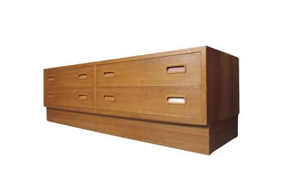
Vintage Carlo Jensen Danish Teak Entry Dresser for Hundevad & Co.A1 Consignment and Auction Gallery Inc4.4(16)See Sold PriceMar 07, 2024
3 Jewish Humor Postcards - Hebrew Publishing Co. NYLevy Auction House4.3(11)See Sold PriceFeb 27, 2024
4 Early Century Cookbooks - 1916-1936North American Artifact Auctions4.6(184)See Sold PriceApr 20, 2024
HAMMOND'S READY REFERENCE HISTORICAL ATLAS 1920North American Artifact Auctions4.6(184)See Sold PriceApr 20, 2024
1904 Japan Cover Kobe to Stapleton NY USA Winckler and CoMynt Auctions4.6(689)See Sold PriceFeb 27, 2024
[LITHOGRAPHY]. Steamship Lines - 19th Century Menus and Tra...Potter & Potter Auctions4.6(544)See Sold PriceMar 07, 2024
1905 20th Century Atlas of Boone County IllinoisMatthew Bullock Auctioneers4.7(1.8k)See Sold PriceFeb 24, 2024
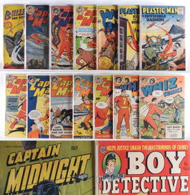
32PC Estate Fresh Golden Age Crime Hero GroupBruneau & Co. Auctioneers4.5(491)See Sold PriceFeb 24, 2024
West Indies. Rand, McNally & Co.'S Indexed Atlas Map of the West Indies.Jasper524.5(9.8k)See Sold PriceFeb 27, 2024
Francis McNally - Antique Map of Nebraska, Kansas, Dakota, Colorado & MontanaProverde Auctions4.3(3)See Sold PriceFeb 28, 2024
Francis McNally - Antique Map of California & MinnesotaProverde Auctions4.3(3)See Sold PriceFeb 28, 2024
Francis McNally - Antique Map of Ohio, Indiana & KentuckyProverde Auctions4.3(3)See Sold PriceFeb 28, 2024
Francis McNally - Antique Map of Washington, Oregon, Idaho, Nevada, Utah & ArizonaProverde Auctions4.3(3)See Sold PriceFeb 28, 2024
Francis McNally - Antique Map of Illinois, Missouri & IowaProverde Auctions4.3(3)See Sold PriceFeb 28, 2024


![[LITHOGRAPHY]. Steamship Lines - 19th Century Menus and Tra... (1 of 1)](https://p1.liveauctioneers.com/928/318880/171361126_1_x.jpg?height=282&quality=70&version=1707501302)