Sold18th century map of the South Downs, published by J18th century map of the South Downs, published by J Stokes London, 53cm by 73cmSee Sold Price
SoldLOT OF 18TH AND 19TH CENTURY MAPSIncludes hand colored map of Turkey published by J. Mawman, May 1819, 1819 map of South America by Stirling & Slade, 18th Century map of Sahara, 18th Century map of England, and 19th Century map of InSee Sold Price
SoldSet of 18th century hand coloured maps of the counSet of 18th century hand coloured maps of the counties of England published by W H Toms 1742, W H Toms Sculpt and J Badeslade del., with text down right hand side to include, Nottinghamshire, WestmorlSee Sold Price
Sold1785 Map of the Crimea & of Tartary in Europe, Russian Army SurveyEngland, 18th century. A map of Crimea published by J. Murray, London, c. 1785. Overall good condition; paper is quite thin. Measures 21 x 19 inches.See Sold Price
SoldSOUTH AFRICA G. E. Pearse, '18th century furniture inSOUTH AFRICA G. E. Pearse, '18th century furniture in South Africa', published by J. L. Van Schaik Ltd, Pretoria 1960, John Kench, 'Cape Dutch Homesteads', published by C. Struik, Capetown 1981, MichaSee Sold Price
17th - 18th Century carving. Map of North Holland.17th - 18th Century carving. Map of North Holland. Published by d 'J. Inherit Ratelband. Engraving on paper. Size: 16 x H, B 24 cm. In good condition.See Sold Price
Sold18TH CENTURY MAP OF SOUTH AMERICA AND AFRICAA map, produced by the British in the 1770s, that details the European Settlements of South America and the Western Coast of Africa. The map is marked at the bottom "Published by T. Cadell, accordingSee Sold Price
18th Century Map of South America"A New and Accurate Map of Terra Firma and the Caribbe Islands", by Emmanuel Bowen, published in [Complete System of Geography,] by William Innys, et al., London, 1747, showing the country of Terra FiSee Sold Price
Period 18th Century Map."Spain & Portugal". Published by J. Johnson, London 1793. 12-3/4" x 14-1/2" plate size. Size 18 -1/4" x 14 -1/2".See Sold Price
Sold18TH CENTURY MAP OF SOUTH AMERICA AND AFRICAA map, produced by the British in the 1770s, that details the European Settlements of South America and the Western Coast of Africa. The map is marked at the bottom "Published by T. Cadell, accordingSee Sold Price
Sold18th C Map of South AmericaEarly 18th century map of South America, hand colored outline, Carte de LAmerique Meridionale Dressee Survant les Nouvelles Observations de Mrs. De lAcademie Royale des Sciences. Laid down on paper, mSee Sold Price
Sold18th Century Map of Tennessee with Native American land"Map of the Tennasee Government Formerly Part of North Carolina from the Latest Surveys, 1795," engraved by B. Tanner, published New York, J. Reid, L. Wayland & C. Smith, showing the Missisippi RiverSee Sold Price
Sold18th Century British Map Of China.Published by J. Johnson, London 1791. Size 17 -1/2" x 14 -1/2".See Sold Price
Sold18th Century British Map of Germany."The Empire of Germany 1791". Published by J. Johnson. Size 17 - 3/4" x 14 - 1/2".See Sold Price
18th Century Maps and Plates (8pc)Eight antique maps: 'Giula', G. Bodenehi, circa 1720. Measures 8" H x 12" W. 'A Plan of the Siege of the Havana, Drawn by an Officer on the Spot 1762.' J. Cary, published by James McGowan and WilliamSee Sold Price
SoldAntique map, L'Amerique Meridionale", south America,Antique map, L'Amerique Meridionale", south America, "L'Amerique Meridionale Divisee en ses Principales Parties", printed in Amsterdam, R. & J. Ottens, mid 18th Century, map is 19.5" by 24". Notice: PSee Sold Price
Sold18th Century Map of the Chesapeak BayMap titled ""Karte Von Der Bay Chesapeak und den benachbarten Landen" by J.N. Bellin, Leipzig c. 175. Map was published as part of the work "Allegemeine Historie der Reisen." Map measures 7.25" x 11"See Sold Price
SoldEngraving, Map of South America, 1765. I. Tirion.A good copper plate engarving, hand colored of South America, published by Isaak Triion, Dutch, 18th century. Framed dimensions: H - 24", W - 28". The map is matted and framed under glass. Not inspectSee Sold Price
Antique Map Of South Africa Cape Colony 18th COld map of S Africa published in London by Orr & Smith - Late 18th Century Dimensions: 9.5" X 11.5"See Sold Price
SoldAntique Map Of South Africa Cape Colony 18th COld map of s africa published in london by orr & smith - late 18th century dimensions: 9. 5" x 11. 5"See Sold Price
Antique Map of South Africa Cape Colony 18th COld map of S Africa published in London by Orr & Smith - Late 18th Century Dimensions: 9.5" X 11.5"See Sold Price
SoldTwo 18th century Southern states maps[Map of the Southern States of America…] by J. Russell, London, H. D. Symonds, 1795, showing states and territories from Delaware south to "Ouaquaphenogaw Swamp" and west to the Mississippi River, iSee Sold Price
Pair of 18th Century Architecture EngravingTwo engravings from John Soane's "Sketches in Architecture", published by I. & J. Taylor, London, 1793. One titled "Plate XI" and one survey map titled "No. 4. Plan for 30 Acres." Sight size measuresSee Sold Price
Sold18th C English Copperplate Map of Northamptonshire18th Century English Copperplate Map of Northampton shire. Map entitled "Northampton Shire" by Robert Morden, ca. 1753. Published in "Camden's Britannia" (London: Swala, Awnshaw & Churchill, 1695-1772See Sold Price
Scarce early American Masonic engraving. Late 18th/early 19th century. Engraved and published by F.Tremont Auctions4.5(297)See Sold PriceFeb 25, 2024
1872 Holy BIBLE & Hitchcock Analysis Gruden Concordance Theology MAPS Holy LandSchilb Antiquarian Rare Books4.8(428)See Sold PriceMar 31, 2024
La Nubia ed Abissinia. Red Sea Ethiopia Sudan Eritrea Arabia. ZATTA 1785 mapJasper524.5(9.9k)See Sold PriceFeb 28, 2024
1675 MED-PHYSICA PHARMACOPOEIA A COMMENTARY BY THE ANCIENT FRIEDRICH HOFFMANNY Elizabeth 4.2(86)See Sold PriceMar 03, 2024
ANTIQUE GEOMORPHOLOGY: 1782 POMPONII MELA DE SITU ORBIS ARMORIAL VELLUM BINDINGNY Elizabeth 4.2(86)See Sold PriceMar 03, 2024
1774: AN ANTIQUE ILLUSTRATED TWO-VOLUME HISTORY OF PERUVIAN DISCOVERY AND CONQUEST WITH MAPNY Elizabeth 4.2(86)See Sold PriceMar 03, 2024
POMPONIUS MELA 1784 ANTIQUE SCHOOL PRIMED VELLUM BINDING CLASSICAL LATIN WORKSNY Elizabeth 4.2(86)See Sold PriceMar 03, 2024
THE WHOLE CHRONICLE OF POLYBIUS ANCIENT IN ENGLISH, 1756NY Elizabeth 4.2(86)See Sold PriceMar 03, 2024
1792 OLD INDIA HISTORY ANTIQUE ILLUSTRATED WITH MAPS OF THE EIGHTEENTH CENTURY IN FRENCHNY Elizabeth 4.2(86)See Sold PriceMar 03, 2024
JOVENAL'S AND PERSIUS FLACCUS VELLUM'S ANTIQUE ROMAN POETRY, PUBLISHED IN DUTCH IN 1709NY Elizabeth 4.2(86)See Sold PriceMar 03, 2024
Antoine Augustin Calmet (1672-1757) - Set of 6 Religious Engravings - Tomb of Zechariah - Grotto ofProverde Auctions4.3(3)See Sold PriceFeb 28, 2024
Antoine Augustin Calmet (1672-1757) - Set of 6 Jewish Engravings - Tomb monument of the kings ofProverde Auctions4.3(3)See Sold PriceFeb 28, 2024
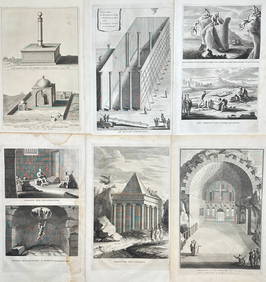
Antoine Augustin Calmet (1672-1757) - Set of 6 Architecture Engraving - Temple of Jerusalem -Proverde Auctions4.3(3)See Sold PriceFeb 28, 2024
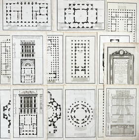
Jean-Francois de Neufforge (1714 - 1791) - Set of 15 Architecture Prints - Development pour unProverde Auctions4.3(3)See Sold PriceFeb 28, 2024
Jean-Francois de Neufforge (1714 - 1791) - Set of 15 Architecture Prints - Plan de l' EdificeProverde Auctions4.3(3)See Sold PriceFeb 28, 2024
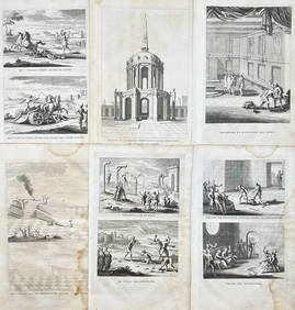
Denis Diderot (1713 - 1784) & Jean Le Rond d’Alembert (1717 - 1783) - Set of 10 Military Prints -Proverde Auctions4.3(3)See Sold PriceFeb 28, 2024
Denis Diderot (1713-1784) & Jean Le Rond d’Alembert - Set of 10 Military Prints - Empty frame [forProverde Auctions4.3(3)See Sold PriceFeb 28, 2024