Sold18th century map of France, framed, 15"x19"18th century map of France, framed, 15"x19"See Sold Price
Map of France, De la Carte Generale de FranceFramed antique map of France, Suite De L'analyse, De la Carte generale de France. Late 18th century. Measures 15" x 21.25". Framed measurement 20.25" x 26.5".See Sold Price
SoldTwo Antique Hand Colored Engraved Maps1 of Santo Domingo (18th Century) by V. Vann & G. Pazzi. Approx. 8" H x 11" W w/o frame, 12" H x 15" W framed. 1 of Provence, France from Honduis-Mercator Atlas (16th Century). Approx 6 1/2" H x 7 1/2See Sold Price
SoldANTIQUE MAP FRANCE SUTTON NICHOLLSFine antique map of British Isles by Sutton Nicholls 18th/19th century. Measuring framed 22 x 26 inches wide sight view 15 x 20 inches. Good condition. Printed on laid paper.See Sold Price
Sold18th Century Italian School, oil on canvas, Genre18th Century Italian School, oil on canvas, Genre Scene, framed 15"x19"See Sold Price
SoldMap of ScotlandAn 18th century engraved Map of Scotland by Paul de la Finille with town views. Later hand coloring. Minor discoloration. Map 10 1/2 x 7 1/4" high, framed 15 1/4 x 12 1/4" overall. ESTIMATE $100-200See Sold Price
SoldTwo 18th century maps[North America] hand-colored delineation of regions belonging to Great Britain, the United States, Spain and France, 16 x 15-3/4 in. (sight), [minor edge nicks, fading to colors, minor internal tearsSee Sold Price
Sold3 18C French Interior Genre Architecture EtchingsGeorg Balthasar Brobst France,18th Century A set of three French interior genre scene hand colored etchings. Etching on Paper Largest Framed 15" x 20", From a Boston, Massachusetts estate. Light stainSee Sold Price
SoldDecorative Framed 17th/18th Century Hand-coloredDecorative Framed 17th/18th Century Hand-colored Map of France, depicting "Le Gouvernement de L'Isle de France."See Sold Price
Sold18th Century Map of LincolnshireA double framed 18th century map of the county and city of Lincolnshire, reverse frame lists period description etc. Frame: 24 inches high x 29. Image: 15 inches high x 29. Condition good. Small tearSee Sold Price
SoldMaps, Sevil, Florence Tresnoble Cite(lot of 2) framed maps, ''Sevilla'' (18th Century) and ''Florence Tresnoble Cite,'' circa 1890, after Francois de Belleforest (French, 1530-1583), sight: 14''h x 19''w, overall: 15''h x 20''wSee Sold Price
Sold18th Century French Map of Persia Paris Meridian18th century French map of Persia, based on Paris meridian, framed with glass, 10.6 x 15 in. (27 x 38 cm)See Sold Price
SoldAntique colored map: France "Gallia Antiqua"Antique colored map: France "Gallia Antiqua", 18th century, Nicolas Sanson, 19" x 21.5" (sight), framedSee Sold Price
SoldBritish School, 18th Century, Map of Scotland, haBritish School, 18th Century Map of Scotland Hand-colored engraving, verso with text; apparently in good condition. Framed.* Sight size: 393 x 496 mm (15-1/2 x 19-1/2 in)See Sold Price
Soldmap, Angleterre, EnglandFramed handcolored engraved map, ''Angleterre,'' 18th century, sight: 9.75''h x 7''w, overall: 18.5''h x 15.75''wSee Sold Price
SoldTWO EARLY MAPS. Includes "An Accurate Map of SoutTWO EARLY MAPS. Includes "An Accurate Map of South America", Emanuel Bowen, 18th century, engraving on laid paper, handcolored, matted and framed, 15"h. 16 1/4"w.; and a map of the military districtsSee Sold Price
Two 18th century hand coloured maps including one by GTwo 18th century hand coloured maps including one by G Bickham of Northamptonshire North from London, both framed, the largest 25.5cm x 15.5cmSee Sold Price
Sold[6] Maps of Turkey, Syria and Environs. 18th Century.* Carta Della Siria per L'Istoria Romana di Mr. Rollin, historic map of Syria in Roman times. Antique map, 26x23 cm. * Turchia Nell' Aisa Antica, e Moderna, Mezzogirono, Turkey, 1755. 15x19 cm. * TurcSee Sold Price
SoldTWO EARLY EUROPEAN MAPS. Map of France by Johann BTWO EARLY EUROPEAN MAPS. Map of France by Johann Baptist Homann (Nuremburg, Germany, 1663-1724), engraving on laid paper with handcoloring, 18th Century, 23"h. 25 1/2"w. (framed); and a map of DenmarkSee Sold Price
SoldHandcolored MapFramed handcolored map, Du Globe Terrestre, overall: 15''H x 12''W 18th century?See Sold Price
Sold18th c. Needlepoint MapNeedlepoint map, 18th century, on silk, showing Africa, Middle-East, Europe, Asia, Australia. Framed and with early matting, sight measures 15" x 15", overall with frame 20" x 20". The designation ofSee Sold Price
Sold(2) 18TH CENTURY FRENCH & GERMAN MAPS(lot of 2) Maps; (1) framed map from the "Atlas Universal" by Gilles Robert de Vaugondy and son (France, c.1723-1786), entitled "Gouvernement General de L'Isle de France, divise par Pays, Par le Sr. RSee Sold Price
SoldSEVEN 18TH CENTURY COPPERPLATE ENGRAVED ATLAS MAPSSEVEN 18TH CENTURY COPPERPLATE ENGRAVED ATLAS MAPS, by Blaue and other cartographers. Most depicting regions in Germany and France. Variously poor to fair condition; unframed - five, approx. 15 1/2 xSee Sold Price
Soldmap, Palestine, MaginiFramed hand colored engraved map of Palestine, ''Palaestina, Vel Terra Sancta,'' 18th century, after Giovanni Antonio Magini (Italian, 1555-1617), sight: 5.75''h x 7.25''w, overall: 15''h x 13''wSee Sold Price
Victorian Bronze Statue of Arlequin Harlequin by Rene de Saint-MarceauxBidhaus4.3(747)See Sold PriceFeb 25, 2024
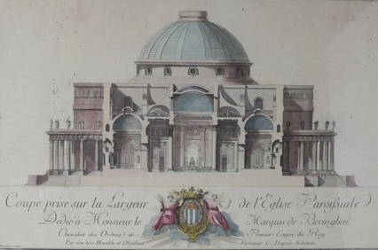
Charles Dupuis French 18th century, Pair Hand Colored Engravings, ArchitecturalGlobal Auctions Company4.3(36)See Sold PriceMar 03, 2024
18th Century Hess Germany Hand colored Engraved MapGlobal Auctions Company4.3(36)See Sold PriceMar 03, 2024
ALBRECHT DURER (1471-1528) "THE LAMENTATION FOR CHRIST".Amelia Jeffers, Auctioneers & Appraisers4.6(101)See Sold PriceMar 07, 2024
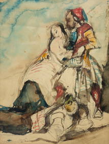
POSSIBLY THEODORE GERICAULT (1791-1824) "SKETCH WITH FIGURES".Amelia Jeffers, Auctioneers & Appraisers4.6(101)See Sold PriceMar 07, 2024
1758 MAP PARTIE DE LA MER GLACIALE contenants La Nouvelle Zemble RUSSIA antiqueJasper524.5(9.8k)See Sold PriceFeb 27, 2024
La Basse-Guinée… Loango, Congo, AngoIa & Benguela Southern Africa BONNE 1790 mapJasper524.5(9.8k)See Sold PriceFeb 28, 2024
La Basse-Guinée… Loango, Congo, AngoIa & Benguela Southern Africa BONNE 1788 mapJasper524.5(9.8k)See Sold PriceFeb 28, 2024
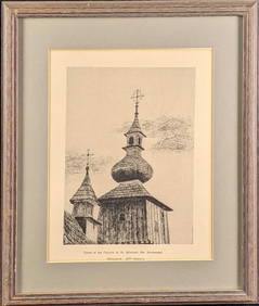
Framed Tower Of The Church Of St Michael The Archangel PrintRapid Estate Liquidators and Auction Gallery4.5(1.1k)See Sold PriceFeb 24, 2024
Late 18th century map of England and Wales sampler and two printsFellows4.3(159)See Sold PriceMar 05, 2024
Framed Coconut Tree Natural History Of History PrintRapid Estate Liquidators and Auction Gallery4.5(1.1k)See Sold PriceFeb 26, 2024
Jean-Francois de Neufforge (1714 - 1791) - Set of 15 Architecture Prints - Development pour unProverde Auctions4.3(3)See Sold PriceFeb 28, 2024
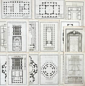
Jean-Francois de Neufforge (1714 - 1791) - Set of 15 Architecture Prints - Plan de l' EdificeProverde Auctions4.3(3)See Sold PriceFeb 28, 2024
Denis Diderot (1713 - 1784) & Jean Le Rond d’Alembert (1717 - 1783) - Set of 10 Military Prints -Proverde Auctions4.3(3)See Sold PriceFeb 28, 2024
Denis Diderot (1713-1784) & Jean Le Rond d’Alembert - Set of 10 Military Prints - Empty frame [forProverde Auctions4.3(3)See Sold PriceFeb 28, 2024
FRENCH CUPIDS OIL PAINTING AFTER FRANCOIS BOUCHERAntique Arena Inc.4.5(852)See Sold PriceMar 09, 2024
South German master of the 18th century, Two drawings: Bishop with putti in clouds and Saint Joseph,Quittenbaum Kunstauktionen GmbH4.4(63)See Sold PriceMar 20, 2024


![[6] Maps of Turkey, Syria and Environs. 18th Century. (1 of 6)](https://p1.liveauctioneers.com/2398/129929/66072856_1_x.jpg?height=282&quality=70&version=1540396562)