Sold1878 Guide to Texas with Large Map & Engravings1878 Guide to Texas with Large Map & Numerous Text Engravings 494. ROCK, James & W.I. Smith. Southern andSee Sold Price
HUNT & Randel. Guide to the Republic of Texas....Hunt & Randel’s Large-Scale Map of Texas, Rivaling Austin & De Cordova “First General Guide to Texas”—StreeteSee Sold Price
SoldAN ANTIQUE MAP, "Spanish North America," 1814,AN ANTIQUE MAP, "Spanish North America," 1814, hand colored engraving on paper, "Drawn and Engraved for Thomson's New General Atlas..." 20" x 25" Note: "A large map of Texas, Mexico and the American SSee Sold Price
SoldPOCKET GUIDE OF PHILADELPHIA CIRCA 1878INCLUDING LARGE COLORIZED MAP OF CITY. NEED REPAIR BUT STILL FRAMABLE. SOME DAMAGE TO BOOK. STILL REVIEWABLE. ESTIMATE: $40-$100See Sold Price
SoldAN ANTIQUE MAP, "The Texas and Oklahoma OfficialAN ANTIQUE MAP, "The Texas and Oklahoma Official Railway Guide Map," CIRCA SEPTEMBER 1919, color engraving on paper, published by Poole Bros., Chicago, for The Texas Railway Guide Co., St. Louis, MissSee Sold Price
Rand-Mc Nally New Commercial Atlas Map of TexasTitle: Rand-Mc Nally New Commercial Atlas Map of Texas Publication Date: c1913 Cartographer: Publisher: RAND MC NALLY & COMPANY Size: 26Height - 36.75Width Description: Shippers Guide Pocket Map. LargSee Sold Price
SoldMOORE, Francis, Jr. Map and Description of Texas..High-Spot Texana Moore's Rare & ImportaSee Sold Price
Texas, New Mexico & Indian Territory MapSize: 18 X 13 inches approx. Unframed. Printed 1878. Centerfold as issued.See Sold Price
SoldCIRCA 1870 PARIS POCKET GUIDE MAPS & CARDSTwo pocket-sized maps of Paris from 1870 and 1878 and twelve mounted photo albumen of French landmarks. We are happy to offer in-house shipping for all but very large or very fragile items. Some interSee Sold Price
SoldTEXAS MAP ENGRAVING PANHANDLE COUNTIES INSETFramed Texas map, hand-colored engraving on paper, a page from an atlas, plate 68, published by William Bradley, c.1880, an inset with Panhandle counties, within a geometric border, sight: approx 17.5See Sold Price
Large map engraving of Paris 1834 Herisson CartographerEustache Hérisson (1759 – 18? ) was a French cartographer with an abundant body of work , particularly active in the years 1810-1820, pupil of Bonne, his work has been extensively reissuedSee Sold Price
SoldFour large maps -Engravings. Temple Mount, Jerusalem,Four maps engravings. * Engraving depicting walled Jerusalem with its different quarters. Latin texts. 36x44 cm. Marginal tears. * Carte ou eft tracee la route que tenoient les flottes de Salomon.See Sold Price
Large map engraving of Paris 1834 Herisson CartographerEustache Hérisson (1759 – 18? ) was a French cartographer with an abundant body of work , particularly active in the years 1810-1820, pupil of Bonne, his work has been extensively reissuedSee Sold Price
1901 - West Texas - XTRA Large Map1901 - West Texas - XTRA Large Map **|**|** This is a beautiful, 114 year old map of West Texas - published in the USA by George F. Cram. The map is much larger than most atlas maps of the same era. TSee Sold Price
1901 - West Texas - XTRA Large Map1901 - West Texas - XTRA Large Map **|**|** This is a beautiful, 114 year old map of West Texas - published in the USA by George F. Cram. The map is much larger than most atlas maps of the same era. TSee Sold Price
SoldLarge copper map engraving plate of birds eye view, 35"Large copper map engraving plate of birds eye view, 35" x 47". Provenance: Property from the Credit Suisse Americana CollectionSee Sold Price
SoldRailway Guide.-Railway Guide.- Appletons' Illustrated Railway and Steam Navigation Guide..., large folding map and maps in the text, advertisements at beginning and end, original printed wrappers, browned, sSee Sold Price
Overland to California By Member of Wagon TrainJohnston, Wm. G. Biobooks. First edition. 4to. Limited edition of 1000 copies. Large folding map. Engravings. Averaging twenty-two and one-half miles a day, Johnston traveled mostly on foot for the maSee Sold Price
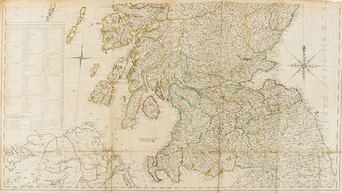
SoldScotland.- Armstrong (Marcus) A New Map of Scotland or North Britain, wherein all the Post and otherNO RESERVE Scotland.- Armstrong (Marcus) A New Map of Scotland or North Britain, wherein all the Post and other Public Roads are Correctly Delineated, large detailed map, engraving with outline hand-cSee Sold Price
SoldDarby Emigrants Guide 1818 with large mapHeading: Author: Darby, William Title: The Emigrant's Guide to the Western and Southwestern States and Territories: Comprising a Geographical and Statistical Description of the States of Louisiana, TSee Sold Price
SoldEmigration Guide With Roessler's Texas Map, 1876Emigration Guide With Roessler’s Texas Map112. [MAP & GUIDE]. [ROESSLER, Anton R. (cartographer)]. HANFORD, Albert. Albert Hanford’s Texas State Register for 1876, and until July Fourth, The One HSee Sold Price
SoldHinton's Arizona Handbook with large map 1878Heading: Author: Hinton, Richard J. Title: The Hand-Book of Arizona: Its Resources, History, Towns, Mines, Ruins and Scenery. Amply Illustrated. Accompanied with a New Map of the Territory Place PublSee Sold Price
SoldHinton's Arizona Handbook with large map 1878Heading: Author: Hinton, Richard J. Title: The Hand-Book of Arizona: Its Resources, History, Towns, Mines, Ruins and Scenery. Amply Illustrated. Accompanied with a New Map of the Territory Place PublSee Sold Price
SoldAPPLETONS GUIDE NORTH-WESTERN STATES MAP ENGRAVINGSAPPLETONS' TRAVELLER'S GUIDE, NORTH-WESTERN STATES MAP ENGRAVING, 1849, H 11 1/2" W 15 1/2":Engraved to accompany Appletons' Traveller's Guide. Pencil dated 1849. "Map of The North-Western States, IncSee Sold Price
CHARLES ROLLIN c1828 Ceasar Hand Colored Africa Military MapLuis Porretta Fine Arts4.3(10)See Sold PriceMar 02, 2024
Birmingham.- Commercial map.- Smith (J. Pigott) To the Right Honourable William Earl of Dartmouth...Forum Auctions4.3(53)See Sold PriceFeb 29, 2024