Claude Monet French 1840 - 1926 Oil on canvas Painting Impressionism Renoir Manet Pissarro Era.International Art Auction Gallery4.5(154)See Sold PriceFeb 24, 2024
Antique American Hudson River School Sunset Landscape Framed Original Oil PaintingCurated Gallery Auctions4.6(120)See Sold PriceFeb 25, 2024
Robert William Wood (1889 - 1979) Texas BluebonnetsPremier Auction Galleries4.3(329)See Sold PriceMar 09, 2024
BIRGER SANDZEN (1871-1954) COLORADO OIL ON CANVAS 1936Soulis Auctions4.8(953)See Sold PriceFeb 24, 2024
George Adomeit (American 1879-1964) CAPE COD LandscapePremier Auction Galleries4.3(329)See Sold PriceMar 09, 2024
Vincent Van Gogh Dutch 1853-1890 Oil on canvas. Paul Gaugin, Cezanne, Degas EraInternational Art Auction Gallery4.5(154)See Sold PriceFeb 24, 2024
Renaissance Old Master Altarpiece Adoration Magi Oil Painting Christ Child Virgin Mary Wise MenHess Fine Auctions4.5(197)See Sold PriceMar 02, 2024
19TH C GERMAN OIL PAINTING BY EMIL ZSCHIMMER C 1872Antique Arena Inc.4.5(852)See Sold PriceFeb 24, 2024
JOHN CONSTABLE ANTIQUE ENGLISH CLOUDS OIL PAINTINGAntique Arena Inc.4.5(852)See Sold PriceFeb 24, 2024
ATTRIBUTED TO GILBERT STUART (MA/RI/UK, 1755-1828)Thomaston Place Auction Galleries4.4(386)See Sold PriceFeb 24, 2024
Pablo Picasso Spanish 1881-1973 Oil On Canvas Painting Dali Magritte Braque Juan GrisInternational Art Auction Gallery4.5(154)See Sold PriceFeb 24, 2024
ATTRIB Francisco Miralles Y Galup (Spain,France,1848-1901) oil painting antiqueBroward Auction Gallery4.8(277)See Sold PriceMar 10, 2024
AMERICAN SCHOOL (Early 20th c) Two WorksJohn McInnis Auctioneers,LLC4.6(502)See Sold PriceFeb 25, 2024
Marc Chagall-Limited Edition -Paris Opera Ceiling after ChagallArt Legacy Auctions4.5(217)See Sold PriceFeb 24, 2024
Sold1875 US Coast Survey Map Great Lakes"Progress Chart of the Survey of the Northern & North Western Lakes July 1st 1875. Primary Triangulation, Telegraphic Longitudes, Shore Line, Topography and Hydrography." Engraved in the Office of theSee Sold Price
Sold1853 U.S. Coast Survey Map of New Orleans1853 U.S. Coast Survey Map of New Orleans, Lake Pontchartrain and the Mississippi Delta hand-colored lithograph, inscribed "U.S. Coast Survey, A. D. Bache Superintendent, Sketch H, Showing the progresSee Sold Price
Sold36 Maps[Miscellany]. 36 Maps. 12 U.S. Coast Survey folded maps (1850-1875), 3 world maps, 6 hemisphere maps, 5 maps of countries in Africa, and 10 others featuring ocean and wind currents, land to water ratiSee Sold Price
SoldU.S Coast Survey 1857 Map. New Orleans, Louisiana"Sketch II Showing The Progress of the Survey in Section No. VIII" A Rare Map centred on New Orleans and Lake Pontchartrain. Also showing Bon Secours Bay (Alabama) Isle au Breton Sound and Vermilion BSee Sold Price
SoldU.S Coast Survey 1856 Map. New Orleans, Louisiana"Sketch II Showing The Progress of the Survey in Section No. VIII" A Rare Map centred on New Orleans and Lake Pontchartrain. Also showing Bon Secours Bay (Alabama) Isle au Breton Sound and Vermilion BSee Sold Price
SoldAN ANTIQUE RECONSTRUCTION ERA SURVEY MAP, "U.S. CoastAN ANTIQUE RECONSTRUCTION ERA SURVEY MAP, "U.S. Coast Survey, Sketch 1, Showing the Progress of the Survey in Section IX from 1848-1875," 1875, lithograph on paper, showing the Texas Gulf Coastline frSee Sold Price
SoldU S Coast Survey 1896 Map. Delaware Bay, Salt Lake Utah"Sketch Showing Extension of Triangulation of Delaware Bay with sub-sketches of Salina and Salt Lake Bases" Large Lithograph Map Published 1896, Washington for "U.S. Coast and Geodetic Survey" Folds aSee Sold Price
Sold[U.S. Coast Surveys].[U.S. Coast Surveys]. Report Of The Superintendent Of The United States Coast Survey...The Year 1872. Wash: GPO, 1875. 267pp. Publisher's cloth. With 24 maps and diagrams, including coasts of Texas, CSee Sold Price
SoldScarce Sea Chart with every building, fort andHarrison, A. M. & Dorr, F. W. et al. Coast Chart No. 59, St. Augustine Inlet to Halifax River Florida. Lithographed map. U.S. Coast and Geodetic Survey, c. 1885. 41 ¼" x 31 ⅛" sheet. Great dSee Sold Price
Distribution of Strata & Eruptive Rocks, Utah MapU.S.G.S., Renshawe, J. H., 1881, Elephant Folio – 28.75 H x 17.34 W Inches, From the 1881 Annual Report U.S. Geological Survey. Extends from the Great Salt Lake south to Utah. Please note that thisSee Sold Price
Sold[CALIFORNIA & NEVADA]. U.S. Coast and Geodetic Survey;[CALIFORNIA & NEVADA]. U.S. Coast and Geodetic Survey; after C.H. Sinclair, et al. Oblique Boundary between California and Nevada, Lake Tahoe to Colorado River. Washington, D.C.: Norris-Peyers Co. PhoSee Sold Price
SoldUS Canada Atlantic & Great Lakes Ports Sea Chart, 1914Title/Content of Map: 'American Atlantic Ports - North Sheet; Inset Chicaco; Boston Harbour; Soo Canals; New York Horbour; Ontario; The Coast from New York to Boston; Buffalo; Montreal; Halifax; NewfoSee Sold Price
West Indies. South Coast of Jamaica from Port Royal toTitle: West Indies. South Coast of Jamaica from Port Royal to Pedro Bluff. Cartographer: Anonymous Publisher: Hydrographic Offfice. U.S. Navy Height: 25 Width: 39 From British Surveys in 1875-1876. ReSee Sold Price
SoldU.S. Coast Survey Map of South Farallon Island and San(lot of 2) Alexander Dallas Bache (American, 1806 - 1867), South Farallon Island, 1855, and San Clemente Island, 1856, U.S. Coast Survey hand-colored copper engraved maps, overalls (with frames): 18"hSee Sold Price
SoldUS Coast Survey Map of the Louisiana CoastAntique US Coast Survey Map of the Louisiana Coast , "U.S. Coast Survey, A.D. Bache, Superintendent", 1855, lithograph, with later hand-coloring, showing Vermillion Bay, LA to Mobile Bay, AL, sight 15See Sold Price
Sold1858 US Coast Survey Map of Charleston Harbor --Title/Content of Map: 1858 US Coast Survey Map of Charleston Harbor -- Preliminary Chart of Charleston Harbor and Its Approaches from a Trigonometrical Survey Under the Direction of A.D. Bache… CartSee Sold Price
SoldU.S. Coast Survey Map San Francisco, CAU.S. Coast Survey, "Entrance to San Francisco Bay California From a Trigonometrical Survey under the Direction of A.D. Bache Superintendant of the Survey of the Coast of the United States TriangulatioSee Sold Price
Sold1853 US Coast Survey Map Of San Francisco"U.S. Coast Survey A.D. Bache, Superintendent, City Of San Francisco And Its Vicinity California. From a Trigonometrical Survey by R.D. Cutts, Assistant. Topography by A.F. Rodgers Sub-assistant. HydrSee Sold Price
Sold1871 US Coast Survey map of Burlington Harbor, VT1871 US Coast Survey map of Burlington Harbor, VT presented to H K Averill, Jr. by the Coast Survey Office 1874, hand colored & mtd by H K Averill, Jr. on its original rollers 29.5” x 23”See Sold Price
Sold1873 US Coast Survey map of Plattsburgh & Cumberland1873 US Coast Survey map of Plattsburgh & Cumberland Bay, NY presented to H. K. Averill, Jr. by the Us Coast Survey 1874 24” x 21.5”See Sold Price
Sold1875 US Coast Survey Chart1875 US Coast Survey Chart showing the entire East coast of the US, the Gulf of Mexico and the Coast of California. Framed in mahogany. On sight 25 1/2 x 25. Overall 30 x 29. Condition: very goodSee Sold Price
1858 US Coast Survey Map of Charleston Harbor --Title/Content of Map: 1858 US Coast Survey Map of Charleston Harbor -- Preliminary Chart of Charleston Harbor and Its Approaches from a Trigonometrical Survey Under the Direction of A.D. Bache… DateSee Sold Price
SoldAntebellum U.S. Coast Survey Map of North Carolinacolored lithograph engraved by Bien of New York, 1859. Behind linen mat in a black wooden frame. DOA SS 34.5 x 24.5 in. Additional high-resolution photos are available at LelandLittle.comSee Sold Price
1858 US Coast Survey Map of Charleston Harbor --Title/Content of Map: 1858 US Coast Survey Map of Charleston Harbor -- Preliminary Chart of Charleston Harbor and Its Approaches from a Trigonometrical Survey Under the Direction of A.D. Bache… CartSee Sold Price
1875 Rand Avery and Co. Map of Express Companies and Railroads of the USA and CanadaJM Hobby Supply and Railroad Artifact Auctions4.4(126)See Sold PriceFeb 24, 2024
Rand McNally Railroad Map of Arizona-1909JM Hobby Supply and Railroad Artifact Auctions4.4(126)See Sold PriceFeb 24, 2024
Rand McNally Railroad Map of Washington-1906JM Hobby Supply and Railroad Artifact Auctions4.4(126)See Sold PriceFeb 24, 2024
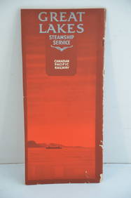
Canadian Pacific RY Great Lakes Steamship 1919 Brochure and TimetableJM Hobby Supply and Railroad Artifact Auctions4.4(126)See Sold PriceFeb 24, 2024
LARGE LATE 17TH C. DUTCH CHART OF CANADA, GREAT LAKES, NEW FRANCE, LABRADOR, HUDSON BAY, BY PIERREThomaston Place Auction Galleries4.4(386)See Sold PriceFeb 24, 2024
LATE 17TH C. FRENCH MAP OF THE NEW WORLD BY ALEXIS-HUBERT JAILLOT (1632-1712)Thomaston Place Auction Galleries4.4(386)See Sold PriceFeb 24, 2024
BOTH TITLE PAGES OF COLLINS" COASTAL SURVEY, 1776, IN MATCHING FRAMESThomaston Place Auction Galleries4.4(386)See Sold PriceFeb 24, 2024
[MAP]. [ALBRIZZI, Giambatista, 1698-1777]. Carta Geografica...Potter & Potter Auctions4.6(539)See Sold PriceMar 07, 2024
1940s WWII Great Lakes IL US Naval Training Station Happy Hour PostcardMynt Auctions4.6(680)See Sold PriceFeb 26, 2024
1852 CHART SHOWING POSITIONS of DAVIS'S SOUTH SHOAL & OTHER DANGERS antiqueJasper524.5(9.8k)See Sold PriceFeb 27, 2024
GEORGE ANDREW CORLEY (DATES UNKNOWN) U.S. TEAM SKI TRYOUTS / MT. HOOD OREGON. 1939.Swann Auction Galleries4.4(65)See Sold PriceFeb 29, 2024
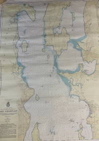
CHART: U.S LAKE SURVEYS/ LAKE CHAMPLAIN/ CUMBERLAND HEAD, NY and SAVAGE ISLAND, VT. TO FOUR BROTHERSChurchill Galleries3.7(213)See Sold PriceFeb 26, 2024
Rare Vintage US Coast Guard Vintage Makeup Compact1 Great Deal Auctions 4.5(258)See Sold PriceMar 09, 2024
Voyage Round the Coast of Great Britain, The Folio Society BookPassion For Antiques3.9(23)See Sold PriceMar 10, 2024
West Coast U.S. Vintage Travel Maps, Brochures 46Grant Zahajko Auctions, LLC4.8(1k)See Sold PriceMar 06, 2024


![[U.S. Coast Surveys]. (1 of 1)](https://p1.liveauctioneers.com/179/14187/4432478_1_x.jpg?height=282&quality=70&version=1193335524)


![[CALIFORNIA & NEVADA]. U.S. Coast and Geodetic Survey; (1 of 3)](https://p1.liveauctioneers.com/928/212515/108628797_1_x.jpg?height=282&quality=70&version=1627420959)


![[MAP]. [ALBRIZZI, Giambatista, 1698-1777]. Carta Geografica... (1 of 1)](https://p1.liveauctioneers.com/928/318880/171361280_1_x.jpg?height=282&quality=70&version=1707501302)