Sold1870 Atlas of Delaware County, Pa w/26 MapsHopkins, Henry W. "Atlas of Delaware County, Pennsylvania. Comprehending 26 Maps. ...", Philadelphia, 1870.See Sold Price
SoldProperty Atlas of Delaware County PA 1934 FranklinFull folio "Property Atlas of Delaware County Pennsylvania, West of Crum Creek" Published by Franklin Survey Co. 300 Walnut Street Philadelphia 1934. Mapped areas include Chester, Media, and Marcus HoSee Sold Price
SoldAtlas of Chester County PAAtlas of Chester County PA, lacking first 15 plates, separated binding & covers, along with New Historical Atlas of Delaware County PA 1875See Sold Price
Sold6 Volumes Chester & Delaware County PA Including6 Volumes Chester & Delaware County PA Including Smith History of Delaware County, Maps-- Dimensions: ---See Sold Price
1870 County Maps of Maryland / Delaware & New JerseyMap Title: County Map of Maryland and Delaware / County Map of New Jersey Cartographer: S. A. Mitchell Place/Date: Philadelphia / 1870 Size: 14" x 11 1/2" Condition: full color; light overall age toniSee Sold Price
SoldMitchell: Antique Map of New Jersey Delaware MarylandTitle/Content of Map: 1870 Mitchell: New Jersey, Delaware and Maryland -- County Map of Maryland and Delaware [on Sheet with] County Map of New Jersey Date Printed: 1870, Philadelphia Cartographer: SSee Sold Price
Mitchell: Maryland & Delaware / New JerseyTwo beautifully detailed and colored county maps, one of New Jersey, the other of Maryland and Delaware, on one sheet from the 1870 edition of Mitchell's popular New General Atlas of the world. The maSee Sold Price
Mitchell: Maryland & Delaware / New JerseyDescription: Two beautifully detailed and colored county maps, one of New Jersey, the other of Maryland and Delaware, on one sheet from the 1870 edition of Mitchell's popular New General Atlas of theSee Sold Price
Mitchell: Maryland & Delaware / New JerseyReserve Reduced! Two beautifully detailed and colored county maps, one of New Jersey, the other of Maryland and Delaware, on one sheet from the 1870 edition of Mitchell's popular New General Atlas ofSee Sold Price
SoldMitchell: Maryland & Delaware / New Jersey, 1870Title/Content of Map: Mitchell: Maryland & Delaware / New Jersey, 1870 Date Printed: 1870, Philadelphia Cartographer: S. A. Mitchell Size: 14" x 11 1/2" Two well detailed and colored county maps, oneSee Sold Price
Mitchell: Maryland & Delaware / New JerseyTitle/Content of Map: Mitchell: Maryland & Delaware / New Jersey Date Printed: 1870, Philadelphia Cartographer: S. A. Mitchell Size: 14" x 11 1/2" Two well detailed and colored county maps, one of NewSee Sold Price
Mitchell: Maryland & Delaware / New JerseyTitle/Content of Map: Mitchell: Maryland & Delaware / New Jersey Date Printed: 1870, Philadelphia Cartographer: S. A. Mitchell Size: 14" x 11 1/2" Two well detailed and colored county maps, one of NewSee Sold Price
Mitchell: Maryland & Delaware / New Jersey, 1870Title/Content of Map: Mitchell: Maryland & Delaware / New Jersey, 1870 Date Printed: 1870, Philadelphia Cartographer: S. A. Mitchell Size: 14" x 11 1/2" Two well detailed and colored county maps, oneSee Sold Price
Mitchell: Maryland & Delaware / New Jersey, 1870Title/Content of Map: Mitchell: Maryland & Delaware / New Jersey, 1870 Date Printed: 1870, Philadelphia Cartographer: S. A. Mitchell Size: 14" x 11 1/2" Two well detailed and colored county maps, oneSee Sold Price
SoldASHER & ADAMS NEW TOPOGRAPHICAL ATLAS GAZETTEER OF NEWASHER & ADAMS NEW TOPOGRAPHICAL ATLAS GAZETTEER OF NEW YORK, DELAWARE, SULLIVAN, GREENE, ULSTER, ORANGE, COLUMBIA, DUTCHESS AND PUTNAM COUNTIES, 1870, IN NICE PERIOD OAK FRAME, MAP MEASURES 18" X 24",See Sold Price
Lloyd Map of NY, NJ, PA, OH, DE, MD, VA, WV, ON, 1873Map: Lloyd Atlas Map of NY, NJ, PA, OH, DE, MD, VA, WV, ON - County Map of New York, New Jersey, Pennsylvania, Ohio, Delaware, Maryland, Virginia, West Virginia, Province of Ontario Cartographer: H LlSee Sold Price
Sold1913 ATLAS Delaware County PA Pennsylvania Volume1913 ATLAS Delaware County PA Pennsylvania Volume Two. Mueller. City of Chester, Upland, Bethel, Birmingham Twp, etc. Approx 55 plates. --- This is just one of hundreds of antique books being sold atSee Sold Price
Sold1929 ATLAS Volume 1 Delaware County. PA Pennsylva1929 ATLAS Volume 1 Delaware County. PA Pennsylvania atlas HM Klinge. Index and 34 tabs with plates. Includes: Boroughs of Aldan, Clifton Heights, Collindale, Colwyn, Darby, Swarthmore, etc. TownshipsSee Sold Price
Sold1937 Atlas of Montgomery County PA, 31 Maps1937 Atlas of Montgomery County Pennsylvania, Volume C. (Franklin Survey Company) all 31 maps are present and included in this full-sized folio. Highlight of note is the " willow Grove Park".See Sold Price
SoldDelaware County (PA) Atlases: 1909/29[2] A.H. Mueller. "Atlas of Delaware County East of Ridley Creek...", Vol. I. Philadelphia, 1909-10; together with: F.H.M. Klinge. "Atlas of Delaware County Penna...", Vol. I. Lansdale, PA, 1929. CONDSee Sold Price
1880 Smith Delaware County (PA) AtlasBenjamin H. Smith, Atlas of Delaware County, Pennsylvania... A History of the Land Titles in the County. Philadelphia, Henry B. Ashmead, 1880; Together with: George Smith, MD, History of Delaware CounSee Sold Price
SoldEverts and Stewart - Historical Atlas of DelawareEverts and Stewart - Historical Atlas of Delaware County. Rebound lacks map of Chester.-- Dimensions: --- US Shipping charge: $35See Sold Price
SoldJOHN MARIN, (AMERICAN 1870-1953), LANDSCAPE FORMSJOHN MARIN (AMERICAN 1870-1953) LANDSCAPE FORMS, DELAWARE COUNTY, PA 1916" Signed and dated "Marin 16" bottom right, signed, inscribed and dated verso, watercolor 16 1/4 x 19 1/4 in. (41.3 x 48.9See Sold Price
Sold3 vols. (Delaware County Property Atlases): Kling3 vols. (Delaware County Property Atlases): Klinge, Frank H., pub. Atlas of Delaware County, Penna. Lansdale, Pa., 1929. Folio, later cloth, gilt-lettered cover label; light wear. Double-page color inSee Sold Price
Crams Map of North Dakota-Complete Railroad System and County Map-1907JM Hobby Supply and Railroad Artifact Auctions4.4(126)See Sold PriceFeb 24, 2024
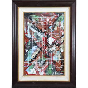
Dennis Sakelson, Bucks County Pa, 20th C. Abstract Oil Painting, Framed, SignedDonny Malone Auctions4.5(1.7k)See Sold PriceMar 04, 2024
General Books - Nicolson - The Counties of Britain - A Tudor Atlas by John SpeedTimeLine Auctions Ltd.4.5(183)See Sold PriceMar 08, 2024
Vintage County Map Of NY State Plate EngravingThe Benefit Shop Foundation Inc.4.3(2.9k)See Sold PriceFeb 28, 2024
Portfolio of 15 County Maps by Robert Morden (English 1650-1703)Nadeau's Auction Gallery4.7(401)See Sold PriceFeb 24, 2024
Rand McNally & Co's New Ideal State and County Survey and Atlas 1911North American Artifact Auctions4.6(182)See Sold PriceApr 20, 2024
Dennis Sakelson, Bucks County Pa, 20th C. Abstract Oil on Board Painting, Signed, FramedDonny Malone Auctions4.5(1.7k)See Sold PriceMar 04, 2024
1905 20th Century Atlas of Boone County IllinoisMatthew Bullock Auctioneers4.7(1.8k)See Sold PriceFeb 24, 2024
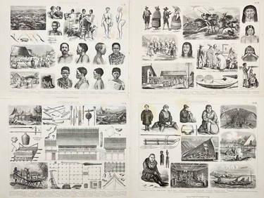
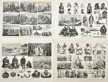
Friedrich Arnold Brockhaus - Set of 4 Prints - Anthropologic Lithography - Sudan - Sennar - Africa -Proverde Auctions4.3(3)See Sold PriceFeb 28, 2024
Friedrich Arnold Brockhaus - Set of 4 Prints - Anthropologic Lithography - Ethnography - Africa -Proverde Auctions4.3(3)See Sold PriceFeb 28, 2024