Gothic Revival Stained Glass Window of The ResurrectionSchmidt's Antiques Inc. Since 19114.8(431)See Sold PriceMar 02, 2024
THE FITZGERALD FAMILY TEA and DINNER SERVICEJohn McInnis Auctioneers,LLC4.5(505)See Sold PriceFeb 25, 2024
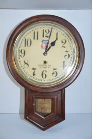
Union Pacific RR Cheyenne, WY Locomotive Shop ClockJM Hobby Supply and Railroad Artifact Auctions4.4(127)See Sold PriceFeb 24, 2024
A CHINESE PORCELAIN GREEN ENAMELED DRAGON MOON FLASK BIANHUBerkeley Auction Gallery4.4(16)See Sold PriceMar 03, 2024
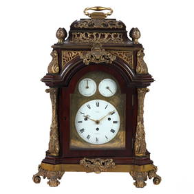
Antique George III Musical Bracket Clock by Hare LondonHill Auction Gallery 4.7(1k)See Sold PriceFeb 28, 2024
No Reserve Early 20th century French / Flemish Design Tapestry 6 ft 2 in x 4 ft 9 in (1.87 m x 1.44Nazmiyal Auctions4.4(34)See Sold PriceFeb 25, 2024
Central Anatolia Konya Antique Rug 4 ft 8 in x 3 ft 8 in (1.42 m x 1.11 m)Nazmiyal Auctions4.4(34)See Sold PriceFeb 25, 2024
PAIR MAGNIFICENT AND LARGE CLOISONNE ENAMEL CRANES INCENSE BURNERSBerkeley Auction Gallery4.4(16)See Sold PriceMar 03, 2024
From Davide Halevim Collection Antique Persian Mohtashem Kashan Rug 10'11" x 7'10" (3.32 m x 2.38 m)Nazmiyal Auctions4.4(34)See Sold PriceFeb 25, 2024
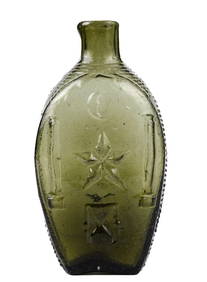
RARE COVENTRY GLASS WORKS MASONIC FLASKJohn McInnis Auctioneers,LLC4.5(505)See Sold PriceFeb 25, 2024
Empire by Buccellati Italy Sterling Silver Flatware Set 99 pieces DinnerBidhaus4.4(762)See Sold PriceFeb 25, 2024
Sold1869 Richardson Map of the Western US -- Map 1869 ofTitle/Content of Map: 1869 Richardson Map of the Western US -- Map 1869 of the Region Between the Mississippi and the Pacific, to Accompany Richardson's "Beyond the Mississippi". Date: 1869, HartfordCSee Sold Price
1869 Richardson Map of the Western US -- Map 1869 ofTitle/Content of Map: 1869 Richardson Map of the Western US -- Map 1869 of the Region Between the Mississippi and the Pacific, to Accompany Richardson's "Bwyond the Mississippi". Date: 1869, HartfordSee Sold Price
1869 Richardson Map of the Western US -- Map 1869 ofTitle/Content of Map: 1869 Richardson Map of the Western US -- Map 1869 of the Region Between the Mississippi and the Pacific, to Accompany Richardson's "Bwyond the Mississippi". Date: 1869, HartfordSee Sold Price
Sold1869 McNally Map of Western US -- Washington, Oregon,Title: 1869 McNally Map of Western US -- Washington, Oregon, Idaho, Nevada, Utah, and Arizona Date: 1869, New York Cartographer: F McNally Size: 10.8 X 8.5 in. Additional Information: This is a charmiSee Sold Price
Sold1869 Mitchell Map of Western US [verso] Mexico andTitle: 1869 Mitchell Map of Western US [verso] Mexico and Central America -- XIX California, Oregon, Idaho, Utah, Nevada, Arizona and Washington [verso] XX Mexico and Central America Cartographer: S MSee Sold Price
1869 McNally Map of Western US -- Washington, Oregon,Title: 1869 McNally Map of Western US -- Washington, Oregon, Idaho, Nevada, Utah, and Arizona Cartographer: F McNally Date: 1869, New York Size: 10.8 X 8.5 in. Additional Information: This is a charmiSee Sold Price
1869 Mitchell Map of Western US [verso] Mexico andTitle/Content of Map: 1869 Mitchell Map of Western US [verso] Mexico and Central America -- XIX California, Oregon, Idaho, Utah, Nevada, Arizona and Washington [verso] XX Mexico and Central America CaSee Sold Price
SoldStunning map of Western U.S. 1869Heading: Author: Watson, Gaylord Title: Watson's New Map of the Western States Territories, Mexico, and Central America Place Published: New York Publisher:Published by Gaylord Watson Date PubliSee Sold Price
SoldColton's pocket map of Western U.S. 1869Heading: Author: Colton, George Woolworth and Charles B. Colton Title: Colton's Map of the States and Territories West of the Mississippi River to the Pacific Ocean Showing the Overland Routes, ProjeSee Sold Price
1869 Mitchell Map of US [verso] Maine, New Hamshire andTitle/Content of Map: 1869 Mitchell Map of US [verso] Maine, New Hamshire and Vermont -- VII Map of the United States [verso] VIII Maine, New Hamshire and Vermont Cartographer: S Mithchell Year/Place:See Sold Price
1869 Mitchell Map of US Midwest -- XIV Ohio, Kentucky,Title: 1869 Mitchell Map of US Midwest -- XIV Ohio, Kentucky, Indiana, Illinois, Iowa and Missouri [verso] XV Michigan and Wisconsin Cartographer: S Mithchell Year / Place: 1869, Philadelphia Map DimeSee Sold Price
1869 Mitchell Map of US [verso] Maine, New Hamshire andTitle: 1869 Mitchell Map of US [verso] Maine, New Hamshire and Vermont -- VII Map of the United States [verso] VIII Maine, New Hamshire and Vermont Cartographer: S Mithchell Year / Place: 1869, PhiladSee Sold Price
1869 Mitchell Map of US Midwest -- XIV Ohio, Kentucky,Title: 1869 Mitchell Map of US Midwest -- XIV Ohio, Kentucky, Indiana, Illinois, Iowa and Missouri [verso] XV Michigan and Wisconsin Cartographer: S Mithchell Year / Place: 1869, Philadelphia Map DimeSee Sold Price
1869 Mitchell Map of US Midwest -- XIV Ohio, Kentucky, Indiana, Illinois, Iowa and Missouri [verso]Title: 1869 Mitchell Map of US Midwest -- XIV Ohio, Kentucky, Indiana, Illinois, Iowa and Missouri [verso] XV Michigan and Wisconsin Cartographer: S Mithchell Year / Place: 1869, Philadelphia Map DimeSee Sold Price
1869 Mitchell Map of Western [verso] Eastern Hemispheres -- The Western Hemisphere Map No. 1…Title: 1869 Mitchell Map of Western [verso] Eastern Hemispheres -- The Western Hemisphere Map No. 1… [verso] The Eastern Hemisphere Map No. 2… Cartographer: S Mithchell Year / Place: 1869,See Sold Price
1869 Mitchell Map of Western [verso] EasternTitle/Content of Map: 1869 Mitchell Map of Western [verso] Eastern Hemispheres -- The Western Hemisphere Map No. 1… [verso] The Eastern Hemisphere Map No. 2… Cartographer: S Mithchell Year/Place:See Sold Price
1869 Mitchell Map of Western [verso] EasternTitle: 1869 Mitchell Map of Western [verso] Eastern Hemispheres -- The Western Hemisphere Map No. 1… [verso] The Eastern Hemisphere Map No. 2… Cartographer: S Mithchell Year / Place: 1869, PhiladeSee Sold Price
1869 Mitchell Map of US Midwest -- XIV Ohio, Kentucky,Title/Content of Map: 1869 Mitchell Map of US Midwest -- XIV Ohio, Kentucky, Indiana, Illinois, Iowa and Missouri [verso] XV Michigan and Wisconsin Cartographer: S Mithchell Year/Place: 1869, PhiladelSee Sold Price
1869 Mitchell Map of Western [verso] EasternTitle: 1869 Mitchell Map of Western [verso] Eastern Hemispheres -- The Western Hemisphere Map No. 1… [verso] The Eastern Hemisphere Map No. 2… Cartographer: S Mithchell Year / Place: 1869, PhiladeSee Sold Price
1869 Mitchell Map of US [verso] Maine, New Hamshire andTitle: 1869 Mitchell Map of US [verso] Maine, New Hamshire and Vermont -- VII Map of the United States [verso] VIII Maine, New Hamshire and Vermont Cartographer: S Mithchell Year / Place: 1869, PhiladSee Sold Price
Sold1869 Richardson/Warren Views of Denver -- Seven ViewsTitle/Content of Map: 1869 Richardson/Warren Views of Denver -- Seven Views of Denver Colorado 1859 Date: 1869, Hartford Cartographer: A Richardson Size: 6.7 X 4 in. This is an attractive set of sevenSee Sold Price
1869 Richardson Birds Eye View of Salt Lake City --Title/Content of Map: 1869 Richardson Birds Eye View of Salt Lake City -- Great Salt Lake City, Utah, 1867 Date: 1869, Hartford Cartographer: A RichardsonSize: 4 X 6.5 in. This is a very nice, smallerSee Sold Price
1869 Richardson Birds Eye View of Salt Lake City --Title/Content of Map: 1869 Richardson Birds Eye View of Salt Lake City -- Great Salt Lake City, Utah, 1867 Date: 1869, Hartford Cartographer: A Richardson Size: 4 X 6.5 in. This is a very nice, smalleSee Sold Price
1869 Richardson Birds Eye View of Salt Lake City --Title/Content of Map: 1869 Richardson Birds Eye View of Salt Lake City -- Great Salt Lake City, Utah, 1867 Date: 1869, Hartford Cartographer: A Richardson Size: 4 X 6.5 in. This is a very nice, smalleSee Sold Price
FLYING A TOURING SERVICE U.S. ROAD MAPS TIN WALL DISPLAY.Dan Morphy Auctions4.2(1.3k)See Sold PriceFeb 25, 2024
1764 Bellin Map of Western Guadeloupe in the Lesser Antilles -- Partie Occidentale de l'Isle de laJasper524.5(9.9k)See Sold PriceFeb 27, 2024
EARLY COLONIAL WEST AFRICA. Empires of Sokoto Gando Mas.Tribes.Fellatah 1882 mapJasper524.5(9.9k)See Sold PriceFeb 28, 2024
West Africa. Liberia Sahara Senegambia Guinea. Mountains of Kong COLTON 1869 mapJasper524.5(9.9k)See Sold PriceFeb 28, 2024
WESTERN AFRICA.Kong Mountains.Caravan routes.Slave Coast.TALLIS/RAPKIN 1849 mapJasper524.5(9.9k)See Sold PriceFeb 28, 2024
Western Sahara. Africa 1885 old antique vintage map plan chartJasper524.5(9.9k)See Sold PriceFeb 28, 2024
PRE COLONIAL WESTERN AFRICA. Shows Mountains of Kong. Tribes. WELLER 1863 mapJasper524.5(9.9k)See Sold PriceFeb 28, 2024


![1869 Mitchell Map of Western US [verso] Mexico and (1 of 2)](https://p1.liveauctioneers.com/5584/188299/94765046_1_x.jpg?height=282&quality=70&version=1608072723)

![1869 Mitchell Map of Western US [verso] Mexico and (1 of 2)](https://p1.liveauctioneers.com/5584/179019/90118111_1_x.jpg?height=282&quality=70&version=1600206230)


![1869 Mitchell Map of US [verso] Maine, New Hamshire and (1 of 2)](https://p1.liveauctioneers.com/5584/179983/90569379_1_x.jpg?height=282&quality=70&version=1601417445)

![1869 Mitchell Map of US [verso] Maine, New Hamshire and (1 of 2)](https://p1.liveauctioneers.com/5584/195879/98794792_1_x.jpg?height=282&quality=70&version=1614724478)

![1869 Mitchell Map of US Midwest -- XIV Ohio, Kentucky, Indiana, Illinois, Iowa and Missouri [verso] (1 of 2)](https://p1.liveauctioneers.com/5584/274166/143946233_1_x.jpg?height=282&quality=70&version=1673389176)
![1869 Mitchell Map of Western [verso] Eastern Hemispheres -- The Western Hemisphere Map No. 1… (1 of 2)](https://p1.liveauctioneers.com/5584/275309/144584413_1_x.jpg?height=282&quality=70&version=1673994422)
![1869 Mitchell Map of Western [verso] Eastern (1 of 2)](https://p1.liveauctioneers.com/5584/179610/90398453_1_x.jpg?height=282&quality=70&version=1600808901)
![1869 Mitchell Map of Western [verso] Eastern (1 of 2)](https://p1.liveauctioneers.com/5584/187575/94368539_1_x.jpg?height=282&quality=70&version=1607465981)

![1869 Mitchell Map of Western [verso] Eastern (1 of 2)](https://p1.liveauctioneers.com/5584/195010/98380725_1_x.jpg?height=282&quality=70&version=1614121450)
![1869 Mitchell Map of US [verso] Maine, New Hamshire and (1 of 2)](https://p1.liveauctioneers.com/5584/190355/95871752_1_x.jpg?height=282&quality=70&version=1609884614)


